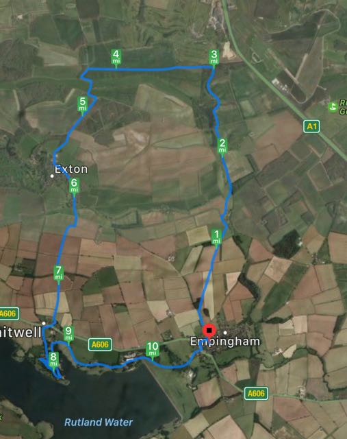
From Empingham, we took Exton Road, across the main road from Church Street.
Ignore the first footpath sign to the right and continue up the gentle hill to the second footpath, also on the right, where there is a bench. A well marked footpath heads slightly east of north with a wooded area on the left. At the end of the woodland the path cuts across the next field, through the hedge and diagonally over another field. Look for the stiles and waymarkers here - if the field has been ploughed you could go round the field edge. The path continues in the same direction and soon goes gently downhill towards Horn Mill Spinney. A short walk through the spinney, and the path climbs the shoulder of a small hill before going down to Horn Mill itself. The trout hatchery here attracts visiting ospreys in spring and summer, and I think it's possible for a fee to take photographs of them fishing.
At the road turn left and walk uphill for a short distance, then take the first footpath to the right and follow it over a bridge across North Brook, then alongside a wooded area called Pug's Park Spinney. the path leads you to Lower Lake and over an estate road to Fort Henry Lake.
 |
| Swans, coots, and noisy Canada geese |


We continued along the footpath beside the lake (heading to Greetham), but turned left at an estate road just after a flight of steps.
 |
| Trees are still dressed in autumn colours |
 |
| Silly photograph time. |

Then it was a question of following the Viking Way into Exton, via the estate yard.


We crossed the A606 and made our way past the church towards Whitwell car park, where we had a coffee in the Crafty Fox cafe, before following the waterside track to Sykes Lane and then the Rutland Round track over the fields and through the woodland and into Empingham.

2 comments:
That's a long recce! ha-ha. Lovely photos.
But what a contrast to he second time we did the walk!!
Post a Comment