and occasionally rides a bike.
A word of warning. The walk descriptions are not detailed enough to guide you - please take a map. The batteries never run out, and you always have a signal. Oh, And don't take left or right as gospel!

Tuesday, September 26, 2023

Gradbach to Lud’s Church

 Tuesday 26th September, with Harry.  Three and a half miles wander with 480 feet of ascent mainly on woodland paths, some of which were a tad muddy. 

We followed signs from the car park at Gradbach, which was busy at lunch time on a September Tuesday.  We walked along the road to our right coming from the car park, and turn to go past the Mill, whose cafe is open only at weekends, close to the scout camping area.

No detailed directions here as we meandered a little, but the place is well worth a visit with its dramatic walls covered in mosses and ferns, lush green and damp at the moment.


Lud’s Church is 18 metres deep and 100 metres long. it was used as a secret place for worship by the Lollards, followers of John Wycliffe who were persecuted in the fifteenth century. There is also the story that Robin Hood and Friar Tuck once used it as a hiding place from the authorities.

It has been suggested as the location inspiring the medieval poem Sir Gawain and the Green Knight.


Earl Sterndale to Hollinsclough, via Chrome Hill and Hollins Hill

 Monday 25th September 2023, with Harry.  

A circular route of just over 6 miles, involving 1050 feet of ups and downs. Steep climbs at that and slightly slippery in places. Muddier underfoot than when we were last in the area.  The weather was fine, so we seized the day. It was pretty gusty on the tops.


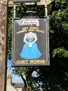
We set off at 10.30 and took the path just after the Quiet Woman. 


The pub is being renovated, with plans for some holiday accommodation, and the path has been diverted slightly.


We followed the route behind houses and across the shoulder of Hitter Hill, heading northwest, then west, with good views of the Dragons Back


The path swings southwest to cross the road between Glutton Bridge and Glutton Dale. Glutton Farm is on the right. Today we didn’t climb Parkhouse Hill, but followed the lower level path.


 This goes more or less west, and turns right (north) along the minor road at the point where a bridleway/track heads west.


The footpath for Chrome Hill (1394 feet) goes off to the left, and we followed it directly up the hill, through a wooded section, then open grass and rocks.


 At one point we saw a kestrel hovering.  Lots of flowers still, harebells, hawksbit, yarrow, gorse…Views back to Parkhouse Hill are dramatic.


The wind was noticeable at the top but we found a sheltered grassy patch to indulge in a coffee.


The way down was slightly tricky in one or two places, mainly because of dampness underfoot.


We took the path through a gate and headed north alongside a wall, going quite steeply uphill. The path turns left and and goes gently downwards, curving west then south. We turned left after passing Booth Farm and the entrance to a track (labelled ‘No access to Booth Farm’. 


The path next to the drystone wall.


A short steep climb to the top of Hollins Hill, a tumulus, at 1480 feet, and a long gentle slope downhill, with a drystone wall on our right. 


Chrome Hill and Parkhouse Hill

This took us down to join a track to the footbridge over a brook and into the village of Hollinsclough.


 The cafe is not open on Mondays, but we sat on a bench nearby to eat our sandwiches. We’d done 4 miles by now, though it felt more. Definitely not my usual Northants terrain, nor yet the New Forest.

Along the road towards Longnor for a short distance. We passed some vociferous ducks in the brook, and saw lots of house martins flying around, feeding for the long flight south.


To return we decided to follow the bridleway/ track back to the track round the bottom of Parkhouse Hill, and retrace the footpath back to base. 


At the start of this track is Hollinsclough Honesty shop, where we bought some Staffordshire honey and a piece of cake each.


A surprisingly strenuous walk.

Monday, September 18, 2023

Corby Kingswood to East Carlton Park

 Monday 18th September, with Norma and Maureen. Just over 7 and a half miles.

We chose this walk because the weather forecast was not good, and none of us had walked huge distances for the last week or so.

In th]e event the weather held out apart from a five minute hail shower just as we emerged from a tree lined path.

The usual route, through Kings Wood, then along Danesholme Road to the junction with the A6003. Crossing with care to reach the footpath sign on the west side of the road.

The first field has been ploughed and prepared for the next crop - hard dried soil makes for an unpleasant surface. We head north west to a wooden footbridge on the field boundary. This is in a shallow dip and can’t be seen from.the start of the path. 

We head for a small low concrete platform and leave it slightly to our left and aim for the trees ahead, until we catch sight of the bridge and adjust our route if necessary.

From there we have another similar field to cross, this time aiming for an oak tree on the right hand edge of a copse. We are still going north west.


The water towers on the 6003 are visible over to the east.


We walk through the corner of the copse, and turn slightly right to follow the field edge then follow the route of the path to cross over the farm track from Middleton Lodge Farm, continuing until we enter a somewhat overgrown tree covered section, where I attacked a few recalcitrant brambles.


This emerges on to a bridleway, where we turned right and then followed it round to the left until we reached the A427. The traffic along here can be fast.

We crossed and then followed the track, avoiding the left hand fork to the mushroom farm. This is another overgrown section and brings us to the old road from Corby to Harborough, now much quieter.

We crossed this , and negotiated three stiles to cross the fields and reach the back road into Middleton, we turn left when we reach the last stile, and head west to the main road.


Here we turn right, then take the footpath between two houses, which takes us to the bottom edge of East Carlton Park. We go into the park and walk uphill to the cafe.

For the return lag we use a slightly different route, down to the footpath below the park, then straight up the hill to the old Corby Road, joining our route out and returning.


Wednesday, September 6, 2023

Kettering (Weekley Glebe Road to Fox and Peony)

 Tuesday 5th September 2023.  Just under four and a half miles mainly in the shade of woodland areas. Chosen because of the hot weather. With Marta.