and occasionally rides a bike.
A word of warning. The walk descriptions are not detailed enough to guide you - please take a map. The batteries never run out, and you always have a signal. Oh, And don't take left or right as gospel!

Saturday, August 31, 2013

Two Rutland bicycle rides

More cycling than I've done for ages.


Ride 1 - via Preston, Ridlington and Braunston

This involved a few hills - the roads were much quieter than the tracks around Rutland Water.

Manton church

A glimpse of the water from higher ground

The lost village of  Martinsthorpe


Ride 2 - via Langham, Barleythorpe and Oakham, then via Exton, Fort Henry and Barnsdale.


Thursday, August 15, 2013

Darwen Jubilee Tower, Lancashire


Wed, 2013 Aug 14 10:31 AM 
Led by Mike. With Eddie, Barry, Gordon, Maureen and me. A short morning walk before the drive back. Fine and sunny.


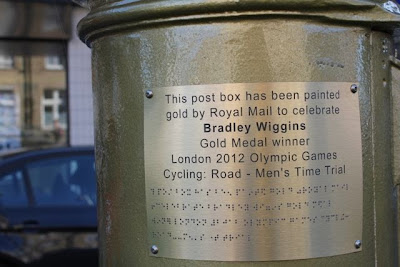
Just the job for a fine morning's leg-stretch before we travel home.  But first we have a small pilgrimage to make in Chorley to celebrate a local resident who rides a bicycle.


We set off from the café and car park at Roddlesworth Information Centre, Tockholes.  We go past Hollinshead terrace - a row of weavers' cottages, and follow the bridleway until we reach a junction. 
We turn left and almost immediately leave the bridleway for a steep track uphill, with a stone marker for the tower.


We follow the track to the edge of the plateau, then turn right before circling back round to the tower itself. We take a small track as a short cut and have to leap a ditch. 

The 85-foot high Jubilee Tower was built in 1898 to celebrate Queen Victoria’s Jubilee. It was paid for by local people and represents the victory of an 18 year long legal battle where local people re-established their ancient rights of access to the moor.

We climb the 82 steps of the spiral stairs to the windy viewpoint. You can see the Yorkshire 3 peaks, some of the Lake District hills and the Isle of Man on a clear day.  We're not quite convinced today.


Then it's complete the circle of the plateau and down the way we came up.  We call in the café for a pre-journey snack.  Their bird feeders with one-way glass offer a great spectacle, mainly tits and a grey squirrel today!


Map and details


Rivington Pike, Lancashire


Tue, 2013 Aug 13 12:55 PM British Summer Time
Led by Mike. With Eddie, Gordon, Barry, Maureen and me. Fine and dry after a wet morning. 1 162 feet of climbing, 10 miles walking.  Max elevation 1 283 - on the ridge.


After breakfast the weather looked distinctly unfriendly, so we headed for the town centre, picked up some provisions from Booths, and wandered round the market. 
Still the weather gods were not smiling. OK, a garden centre/emporium/café visit could do the trick. 
Eddie claims his bench, Maureen claims an Eddie
Soon after midday the clouds lifted and the downpour stopped.  Time to head for the hills.  We park at the Great House Barn, with its café and the Go Ape treetop adventure park.
This is as Ape as we're Going  today
We walk alongside Lower Rivington Reservoir, cross to the upper reservoir. We walk on the west and north sides of Yarrow reservoir, gradually gaining some height.


 We head east and make a small detour to visit the Wellington Bomber Memorial


In memory of  six airmen killed when a Wellington bomber 
crashed on these moors on Nov 12th 1943
Back down to Lead Mines Clough, and a steady climb along track and footpath. 


It gets boggy near the top, until we reach the magnificent flagstone causeway at the highest point of the ridge.   We turn sharply to the right and head more or less south toward Rivington Road. When the flagstones stop we follow the wall downhill. 

A quick break - I'm ready for those sandwiches now! 

We reach the road and turn right for a short distance before turning off to the left along Georges Road - for some reason I didn't take photos of the surface! One of the least comfortable underfoot, anywhere.  
This takes us gently round to the Pigeon Tower, at the top of the Terraced Gardens, designed by Thomas Mawson in the 1920s, for Lord William Leverhulme of soap and Port Sunlight fame.
The Pigeon Tower


A brief exploration and off we go towards the tower on the Pike itself. 

Winter Hill, not too far away is higher, but the views from the Pike are well worth the climb, even though they are a little hazy.


From here it's all downhill.  First the gardens and their ruins and lake.


Then down through the woods, past Rivington Hall and Barn, and on to the car park. 

For a couple of us, a turn round the car park brings the total mileage to over ten. Whatever can be measured will be measured even unto the point of meaninglessness? 

A fine walk, with a real "hill" feel.  A bonus - we found a few bilberries.

Map and details

We get back and have time to change and go out for our meal to celebrate Gordon's approaching special birthday.


Healey Nab, Chorley


Mon, 2013 Aug 12.    4:21 PM 
Led by Mike. With Eddie, Gordon, Barry, Maureen and me. Excellent afternoon walk. Fine weather actually!
5.4 miles. Around 580 feet of climbing.

We set off from Froom Street and cross the Leeds-Liverpool Canal. I've never seen it so far west before, but greet it like a long-lost friend all the same.  A very quiet stretch of water this afternoon.

We have to cross the M61 - not quite so quiet.  After a bit of road near new housing estates we turn off to our left coming close to a couple of ponds and then head gently uphill through Healey Wood.

When we get to the top, Eddie's a tad disappointed to find that the quarry he remembers is so overgrown that it's invisible.  All the same he adds a ritual stone to the summit cairn.
I may be wrong, but Mike could be explaining where we're walking tomorrow! Or it could be Blackpool Tower!
View over Chorley, with Blackpool Tower in far distance - see below.


The cairn
We make our way down, across Heapey Fold Lane and east to meet Moor Road, past the end of Anglezarke Reservoir, which looks a bit low just here.
Just past the reservoir,  we turn onto a track by Joan Meadow Wood, which takes us north then west to wards White Coppice.

Down from the heights - I nearly forgot - this is the magical cricket ground?

Froglet? Toadling?

White Coppice village
 We skirt a village and outlying domestic animals - geese and goats.
Noisy critters


Not long until we reach the car and head back, hungry and ready to hit the local Wetherspoons for a meal along with Mike and Jan.

Map and details - ignore the long straight line at the end!