Walk taken from Heather MacDermid's book "Foxton Locks to Rutland Water". Walk no. 7. You also need a map.
We started from the village hall, and walked to the T-junction with the road to Melton Mowbray. Here we turned left and crossed the road a little further down to walk along Digby Close.
The footpath starts between houses 16 and 17. The footpath leads into a field, with great views. We caught sight of two green woodpeckers flying between the trees.

Keep the hedge on the left and aim for the bottom corner of the field. Go through the gates and continue following the waymarkers to Springfield Hill. Ignore a bridleway going to the right and continue along the farm track downhill. At the bottom of the hill the main track swings round to the right, but the path we want is slightly to the left and goes across the dismantled railway line, passing the old station buildings.
 |
| Lowesby station, looking less charming than when I saw it in October 2011 (see below) |

We pass under power lines and with the hedge on our right head uphill. The path is easy to follow and well marked, and after half a mile or so we saw Lowesby church ahead of us.

A patchwork of fields lay over to our left.

We paused briefly on the steps of the church, then continued to follow the path - well waymarked here to keep walkers away from private areas.
 |
| Lowesby church |

The path meets a minor road (Park Road) where we turned right and walked uphill and along to the junction with the B6047 Melton Road.
We picked up the footpath opposite the junction. It heads north alongside a triangular spinney, and to a second spinney, where there are gates enclosing a small area. We had a pause here to shelter from a shower.
 |
| it was a bit damp out there. |
At this point the official path crosses the field, but we walked round the edges since it was unclear. There is a track on the right hand side of the hedge, and at the corner of the field we changed over to the other side. The hedge was now on our right. We went under the power lines and cut across the corner of the field along the path to the farm gate. The village of Twyford was in sight and we headed for it. We passed the play area, and the old school, and had a light lunch and coffee in St Andrew's church porch.
 |
| Important dates on the old school? |
We then walked past the school and followed the road for a short distance, until we saw a footpath sign on the right hand side, just before the speed derestriction sign.

There was a stream on our left. We headed uphill towards some brick barn buildings, and followed the waymarks, going to the left of the barn.
From here there were two large fields where the path was not laid out and the waymarks were tricky to see. We walked round the edge of one, and through the other, keeping to the track with the help of GPS as far as possible.

The crop was long and wet and not a lot of fun was had walking through.
The book we were following, dated 1989, warned that this part of the walk is not well cleared or waymarked, and things seem to have improved only marginally in the last thirty years!

The viaduct was visible over to our left - on this walk we didn't go under it.
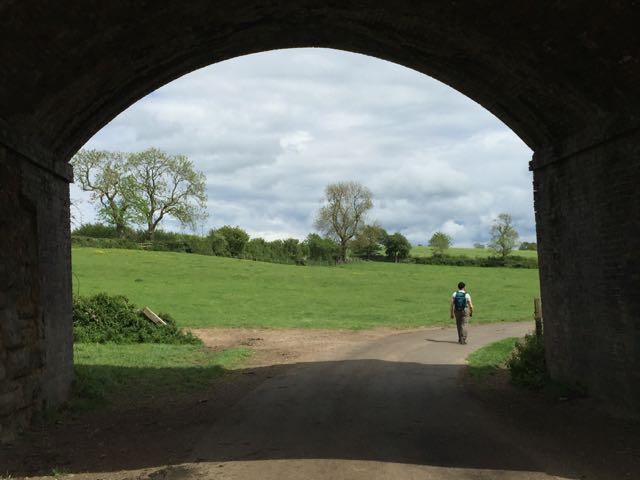
After this there was a field with horses, where we saw a hare. From here there was no problem with waymarking or the route to follow. We came to a small road, where we turned left and very soon right along a lane to Marefield, which led us through pasture land where lots of cows were grazing, before going under the railway bridge and into Marefield.
 In Marefield the footpath goes through someone's garden - there is a gate and clear markers, but it seems a little odd. From here the path is pretty clearly marked as it crosses a stream and a disused railway line, heading towards Tilton. We walked to the left of John's Wood and joined Marefield Lane to Tilton. We turned right and walked the short distance back to Tilton.


There was a stream on our left. We headed uphill towards some brick barn buildings, and followed the waymarks, going to the left of the barn.
From here there were two large fields where the path was not laid out and the waymarks were tricky to see. We walked round the edge of one, and through the other, keeping to the track with the help of GPS as far as possible.

The crop was long and wet and not a lot of fun was had walking through.
The book we were following, dated 1989, warned that this part of the walk is not well cleared or waymarked, and things seem to have improved only marginally in the last thirty years!

The viaduct was visible over to our left - on this walk we didn't go under it.
After this there was a field with horses, where we saw a hare. From here there was no problem with waymarking or the route to follow. We came to a small road, where we turned left and very soon right along a lane to Marefield, which led us through pasture land where lots of cows were grazing, before going under the railway bridge and into Marefield.