and occasionally rides a bike.
A word of warning. The walk descriptions are not detailed enough to guide you - please take a map. The batteries never run out, and you always have a signal. Oh, And don't take left or right as gospel!

Thursday, May 23, 2013

Offord Cluny and Godmanchester circular


Thu, 2013 May 23 9:46 AM Western European Time 
Led by Barry, with me and Gordon. Track walking, then riverside. Clear paths, very flat, dry underfoot apart from a small section in Portholme Park. Just over 9 miles. Weather mostly dry, some sun, a couple of showers. Cold wind. Coffee and a toasted teacake in Godmanchester.
Photos taken with Fujifilm FinePix L55 - my very cheap point and shoot.


Offord Cluny church
We leave the church behind us and turn right past the village hall, and then left along New Road, heading east. This soon becomes  narrow, and climbs up gently to reach Waterloo Farm.  Here it becomes a bridleway, and turns slightly to the right, then due south for a hundred or so yards, before swinging left and due east once more.  Before long it joins a north-south bridleway - with signposts.

We take the route to Godmanchester - north.  It descends gently for almost 2 miles into the town. This is part of the Pathfinder Long Distance Walk
The Pathfinder Walk (46 miles) was designed by the RAF as a heritage trail in memory of the RAF Pathfinder Force and links up the 4 airfields (Wyton, Graveley, Oakington and Warboys) used by the Pathfinders when they were set up in 1942. The route runs through farmland, fen and open heath but also has some road walking.

Godmanchester
There is a friendly café, so we stop for a break and elevenses.
The Queen Elizabeth Grammar School
In May 1561, at the request of the townspeople, Queen Elizabeth I issued letters-patent granting her name to the school. 

The two pictures below are of a building erected in 1844 by one mayor, Edwd Martin and enlarge in 1899 by another mayor, W. Gadsby.

I like the chimneys.

messing about on the river
The view should improve when the construction work is finished
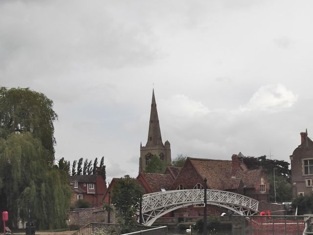
The Chinese Bridge
We cross the bridge into the lovely riverside parkland,  but have to pause to shelter from a sudden hailstorm.

We walk as far as Portholme Meadow, reputed to be the largest meadow in England. It was formed from silt when the Great Ouse flooded, and according to the info board it still floods in the winter. It's covered with buttercups and a small pink flower at present.

We're now walking along the Ouse Valley Way, and follow the path.
Comfrey flowers by the path
 We see Hinchingbrooke Castle on our right, before the path  turns south close to the river.  
Hinchingbrooke Castle has sprouted a phone mast
The trees and hedge shelter us effectively from the wind, and we're tempted by a picnic table and bananas at a Brampton pond in a conservation area.
Pond and conservation area
We make our way past Buckden Marina with its very upmarket chalets and boats, and arrive back at Offord Lock. It's a short walk to the car.

Wildlife - the usual swans, geese, ducks, a couple of terns, some swifts.
Map and details


Wednesday, May 22, 2013

Twywell circular


Tue, 2013 May 21 10:34 AM Western European Time 
With Marta. Good weather, fairly flat. Some navigational tests because of poor waymarking, and paths not made clear on the ground. One accidental timer stop. One crossing of A14. About 10 miles ish. Grey weather but no rain.

From Twywell to the footbridge over the A 14 .  We head towards Woodford, and walk through, past the pub and turn right, ignoring the church and paths to the left. We walk for a little way along the road - not too busy, luckily.  The foot[path is clearly marked and we walk along a plain track. Too plain, as it happens, and we realise we have gone a couple of hundred yards too far, so turn back.

How did we miss the tumuli, labelled Three Hills? The usual lack of mapwork, I suppose!  Unfortunately we can't see the path on the ground, but work out where we should be able to meet it by walking along field edges and finally see the waymarkers. Back on track we head for Rectory Farm, and turn left into Great Addington, in search of lunch. We find this at the Hare and 'ounds. It's dropped its aitch, poor sign.  A good enough sandwich, a friendly landlady, and rather dear J2O, but it does the trick.

Off we go again, taking the path from Cranford, beside the Manor House.  We have a slight feeling of dread on seeing the sign "Footpath to Burton Latimer", but hope we'll be able to find the paths on the ground as clear as on the map. It's not to be, of course, and each time we stop and look for a trace of a cross-field "made good" path, we are disappointed.  To cut a long story short, we try our best, find some way markers which don't help a lot, and emerge on the A510 about half a mile to the south of the Round House.  For the sake of simplicity we walk along the road - there is a decent sized grass verge.


At the Round House we take the bridle way north, over the drive to Wold Farm, and a couple of fields, before we turn left along a hedge and then follow a diverted path round the edge of a quarry.  

Then over a field and we have to brave the A14 itself.   Life would be pleasanter with more bridges and subways!  The central reservations makes the crossing simply a matter of patience, and we are on the edge of Cranford.  We have to do a bit of thinking to be sure that we're on the right track towards Twywell  At first we wandered too far to the right.  

Once on course, it's pretty straightforward, and we arrive at the Hills and Dales country park - we walk north east into Twywell. 

We saw and heard a pair of lapwings and lots of red kites.

A footnote - Irthlingborough's Waterloo film centenary!

Map and details

Monday, May 20, 2013

Kings Cliffe circular to Apethorpe

Mon, 2013 May 20 9:35 AM Western European Time 
Led by Mel. Norma, Jill, Phil, Barry, Gordon, Eddie, me. Sllghtly damp, grey, humid. One damp section underfoot. 5 miles.

Just eight of us on this dull morning with slight drizzle in the air.  We park at Kings Cliffe, on the no through road up to Fineshade woods.   

First we go across the main road, past the sign to the Village Hall and Underground Centre, and take the road directly ahead until we reach the Morehay Lane track. We turn left and continue until we find a path through a kissing gate, which takes us up past the clay pits, and alongside rape fields. About 2 miles into the walk we arrive at a road junction, with signs to Spa Farm, Lodge Farm and others.  Here we turn left to take the road into Apethorpe. It comes out by the Kings Head pub. 


Some of us wander into the village for a look at St Leonards church, which is closed, as there has been an attempted burglary recently.   We briefly admire the clock, restored in 1897 for Queen Vic's diamond jubilee, and smartened up for E II R's in 2012.

Then we rejoin the others and have a coffee and banana break. We go back uphill out of the village along the road we arrived on. When we reach the junction we go straight on, following the road alongside Calvey Wood, as far as Spa Farm Cottages.  We go behind them, and soon go through a short stretch of woodland, before turning slightly right to go north, following the field edges down towards Kings Cliffe. 

When we hit Morehay Lane we turn right, over our steps earlier this morning,  and before long turn left over a footbridge, along a track past the old watermill.

The water's flowing but the wheel's not turning


We emerge close to the church and follow the footpath just by the churchyard, between walls, past many narrow alleys, and rejoin the road leading to the cars.  
Cutaway corner for tall traffic.
Kings Cliffe church


Five of us had butties and a drink in Bulwick Pickled Village shop.


Thursday, May 16, 2013

Maxey circular - via Peakirk, Glinton, Etton


Thu, 2013 May 16 9:46 AM Western European Time 
Led by me. With Barry and Eddie. Lunch at the Ruddy Duck. Very flat, dry underfoot. Good weather with a fair amount of sun. Around 10.5 miles [ I had a few hundred yards when garmin was switched off - hence my maximum walking speed of - 146 miles per hour!]

Tuckers Nook - an irresistible street name,  quiet,  somewhere to park unobtrusively, before booting up and crossing the High Street to Quarry Lane. We turn right to follow the public footpath, then take the clear track around the west and south sides of the quarry area. 
Maxey Quarry lies to the South of the village and now consists of lakes attractive to wildfowl, guarded by plenty of signs warning of quicksand, and the dangers of deep cold water. 
It doesn't look too inviting
We join the track which comes from Woodgate Road, just before the bridge over Maxey Cut. This track soon heads east past some  sand and gravel workings.

On the lakes we see grebe, coots, ducks and a vast number of swans, among half submerged willows.


The track crosses the minor road to Etton and arrives at the A15, where there is a choice of culvert-style tunnels below the road.
Just big enough to walk through upright.
The track continues to the east of the A15, and meets Lincoln Road, between Glinton and Northborough at the Nine Bridges Viaduct - road over water. We counted sixteen arches.  
There's a man in a car labelled Traffic Survey - the job doesn't look too arduous, and he's not even counting pedestrians. We turn right and immediately left, and pick up a permissive footpath which takes us to the side of the Cut. 
We turn right and walk as far as a bridge carrying a footpath. There's a heron fishing.


It really isn't bothered by our presence.  We turn right along the footpath, reach the Mile Drove Road, then turn along North Fen Road.  We walk as far as the bridge with a display board about John Clare. For a gentle introduction to his work have a look at this blog.  

A few hundred yards later, our footpath goes off to the left just before the first houses in Glinton. 

We walk along until the path turns right than left, and now we have a possible alternative route. It's that sort of day - we'll try the other path via the course of the Car Dyke.  We overshoot, then return.  We come out in Peakirk just by the magnificent, nay splendid, Old Rectory. A left turn along a narrow footpath brings us to St Pega's church, with its open bell-tower and medieval wall paintings.  This is very much a hidden gem, nestled among the trees, and with no tower or spire advertising its presence from a distance.


 We've walked about 5 miles by now.  Next stop the Ruddy Duck for a bite to eat. Then by street and pavement to Glinton, with a brief nod to Mary Joyce's grave. She was John Clare's first sweetheart. Their romance was thwarted because her family would not accept him socially.  Alas, she died single at the age of 41, in a house fire. Here's a poem Clare wrote about her - before her death.
I can take John Clare's poems in small doses, but he had strong ideas about the changing countryside and its people, and was very much against the enclosure of common land.  His tragic life and depression caused him to be locked in an asylum for some time.
Glinton church


Relaxed goat


On we stride along a street which leads directly to a footbridge over the A15.  This must be the highest we've been above sea-level all day.  We continue at the side of a field of yellow rape flowers, to the turn to Etton, a very small village, with a pub, a fair few horses, and the claim to have won the "Best Kept Village" competition at least three times.
Etton church
We've spied a route that looks better than tramping the hard road back to Maxey, and turn left along another dyke, near a road bridge.

With the help of our map, we wend our way back towards Maxey, meeting several dog-walkers - I think they are vital in keeping some of these paths open to the public!
We return to Maxey along Woodgate Road, and return to the car.

A day of wide skies, long views and plenty of water.  


Wildlife:
Grebes doing a bit of a courtship dance,  a heron staying obligingly still, terns, swallows and a very loud robin in Maxey.

A recent Countryfile programme includes a section on John Clare.  It's about 12 minutes into the programme.

Map and details

Monday, May 13, 2013

Peatling Parva Circular


Mon, 2013 May 13 9:51 AM Western European Time
Led by Barry. With me and Gordon. Fine, with a few showers. 11.6 miles. 433 feet of ascent. A small LR section.


We parked in Peatling Parva, which is actually quite big.  
The seat looks inviting, but we've only been walking two minutes!
Our route is out of the village on the road towards Ashby Magna for almost a mile. Then we turn left on a track to Gilmorton.  
These are less intrusive than the motorway noise.
This is the second track on the left.  We follow it due south for about a mile, before turning right, then left then curving round south west into Gilmorton , an attractive village. We walk through an alleyway and on to Turville Rd, turning left at Ashby Rd, across Main Street.
Gilmorton
 Soon we turn right along Church Lane.


The path turns right just after a house called Moatfield. In the field is - a moat.
The remains of the moated area.
We wander round it before following the path behind the big house and garden, through some trees to a corner of the Ullesthorpe Rd. Our route lies straight ahead, diagonally over a field, then turning right to folllow the hedge, past some farm buildings and into an open field.

Here we have some debate about the route. The paths haven't been remade, but with a little map and grid ref work we have a plan.  We turn left and follow the edge of the field and turn right at the end to join the proper route.

We are now on a bridle way leading almost due west as far as Cotes-de-val.   We ponder the meaning of the name - slopes of the valley/ sides of the valley -  both sound a bit contrived. It turns out that the place was once lived in by a Cotes family. By 1279 it was referred to as Cotes Deyvill.  It was depopulated between the Black Death (1348) and the early 1500s.

We don't detour to look at the moat marked on the map, as our route turns right here and north to the Gilmorton Road.

We turn left, and then right  and walk along the field boundary- but miss our turning to the right. Ok, it's nestled in the hedge, and not immediately obvious. The long and short of it is we notice that we're getting too close to the motorway, and have to retrace our steps, promising ourselves that we'll take a break as soon as we're back on track. We soon find a sheltered and sunny spot.

The path is clear now and we soon arrive at Ashby Magna.


Another timbered building

A post-break break
We go down to Gilmorton Road, turn right then left on Peveril Road, and then left along Old Forge Road. Our path is between Ashby House and the old Forge, and heads north along a track for half a mile or so.  When we meet the waymarker for the Leicestershire Round we turn right to go north east. 

We cross a field with horses in it, then go over a stile into Holly Farm Fishery. A man catches a two-pound carp which he returns to the water.
Not quite so colourful as last October
Another stile, another field and we arrive at the road. We turn left and walk for a few yards to the junction. Our path goes to the right of the hedge.  It's clearly marked and easy to follow, although there are cows there.  They think we want to herd them into the next field, but go peacefully enough.
We follow our route into Willoughby Waterleys along an alley with pansies and dustbins.

We go past the General Elliott of Gibraltar renown.
Our path goes past the church and old rectory.

We walk eastwards, slightly uphill over fields towards Peatling Magna. In a field ahead we think we spy a scarecrow -

but it's moving, and very deliberately. Light dawns - it's a metal detective.

We leave the Leicestershire Round briefly and detour to look at Peatling Magna church.


We take a footpath across the fields to rejoin the Round at the crossroads, and follow it again for a mile. We leave it for good today, by turning right across the stream, below Grange Farm. Almost immediately we turn left and follow the footpath through several fields and then behind Peatling Hall with its fine gardens.
Peatling Hall

the gardens
When we reach the road we turn left and downhill to return to the car.

Map and details