and occasionally rides a bike.
A word of warning. The walk descriptions are not detailed enough to guide you - please take a map. The batteries never run out, and you always have a signal. Oh, And don't take left or right as gospel!

Thursday, December 22, 2011

Pitsford Water

We set off intending to go to Great Staughton, but the A14 traffic was almost at a standstill, so we had a quick change of plan.  7 miles give or take, with Barry and Eddie. Bright, beautiful day.


Spot the squirrel - no prizes!


Map and details

Monday, December 19, 2011

Gretton - Kirby Hall

14 of us for this short walk before our annual pre-Christmas get together at Mel and Norma's.
Weather - icy underfoot, which was better across fields than mud.  The rain began to persist later in the walk. About five and a half miles.

From the village hall, down the track towards Kirby Hall, then just after the junction, follow footpath signs over a few fields, coming out near the recycling plant on Gretton (Brook) Road.  Turn left and follow the road past the turning to Kirby Hall. Go as far as the deer-proof gate.  Turn right along the footpath. We followed this for about half a mile, then turned right to visit the new bridge to Priors Hall, for a photo opp, and a snack break.


From here we retraced our footsteps and continued to Kirby Lane, then along the drive to Kirby Hall, and up the slope behind the gift shop, through the magnificent new gate, which has replaced the very dodgy broken stile.
Across the fields, and down to the four-stile crossing with mud, and up to the metalled track leading back to Gretton.

Thursday, December 15, 2011

Welford - Sibbertoft - Welford

Barry led this walk, with me and Gordon. Almost 10 and a half miles, and the weather was fine, though blustery, and quite cold in the wind. 

We parked near the school in Welford, on West St, and walked  through Butchers Close to the High Street, past a couple of ex-pubs, and the Old Post Office, then turned left, past a development of new houses ( from barns) and across some fields, following a path, which joined the Jurassic Way, and funnelled us between hedges briefly.  We followed the Jurassic Way through some fine scenery, across a tiny river - the infant Avon, of Stratford fame - and up past Sulby Lodge Farm, home of Shep the dog. Soon afterwards we met the Naseby Road, turned left and after Grange Lodge turned right along the path beside Welford Reservoir, then across the weir which divides it from Sulby Reservoir.
a kestrel


A robin watches as we wander by
The path left the water and went nor'nor'east, through a field showing plenty of evidence (humps and bumps and hollows) of the old mediaeval village of Old Sulby. 
Part of Old Sulby, with the northern arm of Sulby reservoir in the background
The path crossed a track and then another field. Just after some buildings on the right the Jurassic Way turns east. We continued along as far as Sibbertoft, where we turned right and walked along the road which skirts the southern edge of the village, ignoring all turnings to the left, and turned right at a green where three roads converge. At a right-angle bend to the left, our path turned off to the right.  There was a fair amount of walking through fields here, some of them muddy - the path was generally easy to follow, in a more or less south-westerly direction, cutting diagonally across the fields.
We were aiming for the small piece of woodland at the end of the reservoir's eastern arm. Through the wood, the path proved to be very muddy and wet, but at the other side we came out on to a decent track. It leads from Oak Tree Farm - which isn't on the map. The track leads up hill gently, and we had a snack break when we reached the gate by the Naseby road. A good choice - sheltered from the wind.


Across the road is the site of Sulby Abbey, founded in c.1155, occupying a considerable area, and frequently visited by Edward II.  According to this site, the monks were not always perfectly behaved, and there are details of some of the punishments they were given.
In 1538, Thomas Cromwell was informed that  'the papistical den of idle and utterly unlearned beasts at Soulbie'  had been broken up.


Next downhill a bit, and over the mighty Avon again, then upwards and onwards to the A 5199.  We seemed to be approaching the A14, closer and closer, noisier - but a few hundred yards short, we turn west and parallel to it, then meet the minor road which crosses it. We turn our backs on the big road, and after less than half a mile, past Welford Lodge Farm, we turn left again and head across country towards Hemplow Lodge Farm. This is a popular child-care nursery, if the traffic along the lane is anything to go by.  There's a manicured lawn and mini-lake here, and the path could do with clearer signs.
We turned sharp right, and straight along the lane,  past a house named the Hemplow Arms,  straight on at the crossroads, and into Welford along West End.

Hora pars vitae - each hour is a part of life


Monday, December 12, 2011

Lyddington - Stoke Dry - Lyddington,

Led by Mel. With Barrie, Steph, Norma, Sue, Gordon, Barry and me.  Around 5 miles. Sunny, some frost to begin with.


I forgot the magic machine.  So no links.  We set off from the centre of Lyddington, taking the minor road which leads to the A 6003.  After a few yards the footpath leaves this on the right hand side and crosses a few fields, going fairly steeply uphill, then swinging back to the road junction at the top.


We crossed the A 6003 and took the road to Stoke Dry.  There are some magnificent views of Eyebrook reservoir as you walk past the houses and the church. We continued downhill along the road as far as a footpath sign to the left, shortly before the strip of woodland on the east of the reservoir.


The footpath hugs the edge of the woodland for a good half-mile or so, then turns left to make its way uphill again. There is a terrific wide 360 degree view from the top. 
 Next the path went gently downhill to meet the A 6003 near Caldecott. A short stretch of walking along the road (with a wide verge here) and we crossed over just by some buildings.  There's a short surfaced access road, then it's more fields, some muddy, with a pretty clear path, which eventually emerges behind farm buildings and out to the road. Turn left and back to the car.


PS in case anyone wondered - that's me in the stripy hat. 

Monday, December 5, 2011

Gretton - Harringworth - Seaton - Lyddington - Thorpe by Water - Gretton

About 11 miles in all. Led by Mel. With Maureen, Eddie, Barry, Gordon, and Joe and Karen. Cold - frosty, then muddy. Sunny and clear.
Same route as on September 29th 2011, with a wrinkle ironed out at Harringworth.
Outside Harringworth Lodge - I haven't been quick enough to catch a real one yet!


Wrapped up warm!
There's a queue for the stile.

I don't think it's opening time.


From the 'correct' path at Harringworth.

Yet another red kite disappears into the distance.
Map and details

Thursday, December 1, 2011

Easton Maudit - Yardley Hastings - Easton Maudit

9 miles. Led by Barry. With Maureen and Eddie. Fine, but a chill wind. Some muddy fields.


First call was Easton Maudit church, and a wander round the graveyard, where Derek Nimmo is buried. 
Then back to don boots and off along the path past this house
where the thatch is supported by some fine rustic poles - or trees.  I like the orange tiles, as well! 
We walked across the fields and gently uphill towards Horn Wood. In the wood we turned slightly right, and followed the path through a line of electricity pylons. Soon after these we turned left with the path, through some more woodland, until we reached the A428, which we crossed. 
We followed the well-marked path (Milton Keynes Boundary Walk) south, then west until we reached the B5388 (Olney - Yardley Hastings. Here we turned right and walked along the road for about half a mile, past Pastures Farm. 
The hollow in this tree looked like an ideal place for someone half our size.

Right,  everyone,  snack-break over!
When we reached a track to the left we climbed one of the few stiles and walked across a field - a notice warned us of low-flying model aircraft, but there were none around today.  
We passed another Pastures Farm over to the right, and the path led us towards Yardley Hastings.  
The first structure we saw was this one. I've discovered that it's a flood storage reservoir - quite empty at the moment.
There is a stream of sorts in the village, with bridges over it to lots of the houses.  The village is very attractive, with its millenium village sign, list of residents in 2000, and human sundial.


There's a village shop, getting into seasonal mode
We walked through the village, past the church (St Andrews) .
The path we took goes to the right, just before a bridge at the end of the village, and continues to the right of the stream - in a deep ditch -  for some distance.
When this path meets another one, you turn right (east) and go uphill gradually, crossing a minor road, and arrive back in Easton Maudit.
Map and details

Monday, November 28, 2011

Ridlington - Belton - Ridlington

Led by Mel. Welcome back!  With Barry, Maureen, Gordon, Eddie, Jill, Ken and me. Some sun, but cold - the first real frost of the year. Another sticky-boot day.

We parked at Ridlington Cricket ground, as instructed last time, then set off down Noel Lane, past the Old Noel Arms and down a muddy lane, where we met a mini-flock of Jacob's sheep.
Over a stile and along the field edge, then through a hedge.


We continued for a mile or so before coming close to the bridge over the river Chater and turning left along the Leighfield Way, which goes slightly west of south towards Belton-in-Rutland.


I cheated here - took this pic in July!

The path pulls uphill for a while, then down to the village. Belton war memorial has a welcoming wall for weary walkers.
From there we walked downhill and turned left very soon at a footpath sign.  We crossed a field and then a footbridge over the stream.  The path went uphill quite gently, and, when it met another path, we turned left to climb more steeply.  From here the track is clear.


The area feels quite remote, apart from Park Farm, which sits on a hill, in splendid isolation.  We arrived back at Ridlington, after a walk of slightly less than 7 miles. 
Map and details

Thursday, November 24, 2011

Castle Bytham - Pickworth - Clipsham - Castle Bytham

On a fine day, still a tad sticky underfoot. With Gordon, Maureen, Barry and Eddie.  10.6 miles.


We set off from Castle Bytham, taking the footpath which goes past the Castle pub, then the church and the cemetery, which has the sign 'Welcome to Castle Bytham Cemetery'!
The path skirts the graveyard and then comes to open country. There was a pretty cold, though southerly, wind.


The fields were a bit muddy, but the path was fairly straightforward, though we did deviate slightly before reaching the Clipsham Road.  On the other side the path led past School Farm - though it looked as though it had been neither for a very long time.
We could see the remains of a small triangular opening in one wall - but I clearly didn't put it in the pic
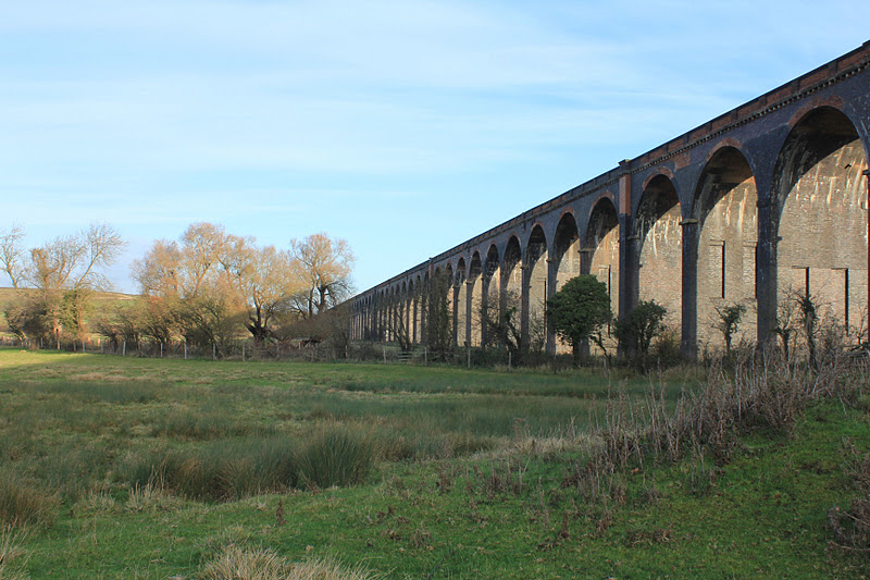
Onwards and south we trudged, until we reached Holywell quarry, where we followed the path just fine until it seemed to head into a wooded gully, which was a little too wooded.  We took an easier route slightly to our right, coming out just a little off track, before reaching the Holywell Road.
The path continued as a bridleway leading gently uphill towards Pickworth Great Wood.
Looking back towards Holywell quarry
From here to Pickworth the path was clearly marked - through the wood and over the fields to emerge beside Manor Farm. We turned left to have a look at the arch, which is all that remains of a church from the 12th, 13th or 14th century. The present owner came out and chatted to us about it.


The present church is very plain and was built in 1821. 
We walked straight past the limekiln this time!  It was only when I read the Pickworth link that I realised it claims to be where the poet John Clare worked for a while.
Here's one I took earlier (18 Nov)
Once again the path was clear, heading slightly north of west, and just after crossing a narrow band of trees we decided to stop for a break - there was a convenient fallen tree. 
It was just after this that I went off track (in spite of warnings that the track has been diverted!).  When I look at the garmin trace on the map link below, it's obvious that I went too far to the west (left) of the wood.  Much better to have stuck closer to the edge.  Another excuse - we were a little distracted by one of the less welcome sights of this part of the world - the hunt were out as well.

An extra half-mile or more added on to the walk, but with the aid of Barry's grid refs and compass bearing, we found our way through Clipsham Quarry, which is marked as 'old' on the map, but is in use. 
 From here to Clipsham things went smoothly again, but as we were behind schedule - we're such timetable-dependent people especially when we're hoping to reach the pub in time for lunch - we decided to give the Yew Tree Avenue a miss this time. 
We reached Clipsham just opposite the Olive Branch pub, and turned right, walked round the bend to the left and turned left - after a little while we turned right and followed the route I had already walked on Nov 18th.  The route is clearly marked from near Clipsham Court, and goes behind Clipsham House, then crosses fields in a north-westerly direction and reaches Addah Wood. It runs alongside then turns right into the wood, and after a while left (north) through Lady Wood.  The path runs fairly close to Stocken Prison perimeter.
We came out of the wood, and once again my map-reading proved less than perfect. Now I can see that the contours mean the path runs along the bottom of the dip!  
A slightly slippery footbridge - at least if your boots are muddy.


If there was a  waymarker, we missed it, and added another half-mile and at least 50 feet of climbing to the route.  However, it was not difficult to find our way back to the track, which then goes under the disused railway to the Castle Bytham Road.  A short uphill walk and we were in the village - just too late for a pub lunch, but fortunately the tea room in the village hall is open until 3 on a Thursday. Very much appreciated by all of us.