and occasionally rides a bike.
A word of warning. The walk descriptions are not detailed enough to guide you - please take a map. The batteries never run out, and you always have a signal. Oh, And don't take left or right as gospel!

Showing posts with label Hallaton. Show all posts

Sunday, January 20, 2019

Hallaton, Cranoe again

Wednesday 16 January, with Marta. The weather was grey, and the slight drizzle we had during the first half turned into more persistent rain later in the walk.
We started the walk from the village green this time, and followed the same route as on the previous walk.


A break in Cranoe church porch again, and lunch at the Hare Pie Cafe this time.

Hallaton to Cranoe circular

Monday 14 January, with Marion, Eddie and Maureen. Around 6 miles.

we followed the route of this walk from Market Harborough Living, pp32-33,  but with a little extra at the start and finish.The early sun didn't last, but it stayed dry.

We parked near the Fox Inn, and walked through the village to the buttercross on the green, then took the lane to the right of the church past the primary school. 
 We went through the gate and alongside the football ground, then through another gate, where we took the left-hand path down towards the brook. The remains of a twelfth century motte and bailey can be seen on the right.
We continued southwest across four fields, passing close to a modern house and crossing the lane to it.  After this we went downhill quite steeply to a spinney, crossing a small stream, then climbed up to the farmyard of Othorpe House. We went straight ahead here and behind a barn sheltering cows, and onward toward Cranoe.
Add
 After some fairly strenuous ups and downs, we decided that a very short diversion to  Cranoe church porch was a good place for a short break.
 A navigational error added a couple of hundred yards to the distance, but was soon corrected, and we were back on track. There are just too many well-marked tracks in Leicesterhire!!

Ready for anything after all that climbing?
 After this the route was clear and level, with fine views all round. The route heads north for almost two miles, along the Midshires Way.  A short distance after crossing a very minor road to Goadby, the path turns right and heads east across fields towards Hallaton. There was a  very muddy bits, going down to a footbridge. 
Another tricky mudslide cropped up just before we joined the lane to Hallaton. We followed this lane over the ford, and uphill briefly, before taking the footpath to our right and through a field and the football field and back into the village.


Sandwiches and coffee at the Fox rounded the walk off nicely.

Tuesday, April 24, 2018

Hallaton, Glooston, Cranoe circular

Monday 16 April, with Maureen and Norma. Track and quiet roads. Just over 7 miles, but a little hard on the feet!

We parked near the Fox Inn at Hallaton, and walked out of the village along the Goadby Road, which turns into a farm track and makes its way gradually uphill, past mounds of earth marking the site of the castle, and onward. We decided against taking any of the footpaths, since fields were still sticky after the winter's rain.  After a couple of miles we reached a T junction, where we turned left towards Glooston. 

 The donkeys were in a field just after Glooston Lodge.

 Lots of primulas and primroses on the way.
The road led us to the junction where the road turns left towards Cranoe, four miles into the walk, and just missing most of Glooston village.  A further mile of quiet road walking took us to Cranoe, where we made good use of the bench in the sun, outside the church.
 The house nearby had a lovely display of aubrieta on the garden wall.
 At the bottom of the hill, we turned left again and followed the slightly busier road for a couple of miles into Hallaton. Sandwiches at the Fox rounded the walk off for us.

The Fox Inn in the 1920s

The Fox Inn in 2018, from a slightly different angle.

Saturday, February 27, 2016

Hallaton, Horninghold, Stockerston, Blaston

Led by Tommy, with Gordon and me. Not too bad underfoot, though some sticky mud in places. Beautiful sunny, clear, cold weather. 7 miles.

From the Fox Inn in Hallaton we turned left and left again on to North End (signposted to Horninghold.  The footpath goes between some newish houses to the left and crosses a few fields before reaching the track through a farm just  northwest of Horninghold. We could have turned right here and walked through the village, but went straight on, then headed for Horninghold Wood which we could see slightly to our right.

We crossed the road (Knob Hill Road) and took the bridleway with the wood on our left. We followed this more or less east for about a mile,  going between Park Wood and Bolt Wood, until we reached the land behind Stockerston Hall and church.
Stockerston Hall and church
 Here we turned south west, heading towards Blaston.
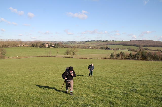
Climbing up the slope.
At the top of a hill, next to the corner of Bolt Wood, we took a break in a sheltered spot at the stile.  We followed the edge of the wood, alongside a ploughed field, then turned left to meet the road, just after Stockerston cross roads, on Belchers Hill.
There was a brief section of road walking before we took a bridleway south west, and mainly  downhill into Blaston.
Billesdon Coplow I believe?


Blaston has a fine selection of buildings to admire.
Greetings, pheasants.


Blaston church
 At the church we turned right and when we reached the gated road to Horninghold, we took it for a short distance before the footpath veered off to the left (northwest now).  A gentler section, again flattish or downhill took us to the Medbourne road and into Hallaton.
The final stretch into Hallaton
 The Fox Inn does a decent meal, and good sandwiches. Very welcome they were too.
The garden of the Fox - we went inside!

Thanks for an interesting walk, Tommy.

Monday, May 12, 2014

Hallaton and Cranoe circular

Mon, 2014 May 12 9.36AM  BST


Led by Mel. Norma, Steph, Terry, Barrie, Vera, Gordon, Maureen, Phil, Andy, Tim, Jackie, Tommy, Marion, Chris and me. Rolling countryside, wide views, fine weather with short showers. Around 7.5 miles.

We park near Hallaton Church - a big group today, sixteen of us. When we're all booted up we set off to walk past the church, along Churchgate, past the primary school, and take the footpath to our left. We walk though a kissing gate, then uphill alongside a hedge.
We follow the Leicestershire Round uphill, past a farm, then down through the edge of Horse Close spinney and uphill past Othorpe House and on almost to the road into Cranoe. 

Here we leave the LR and turn right and follow the path north and up Church Hill.

The path continues north for a mile or so along this ridge - protected from the wind by a hedge.


We cross the Goadby Road track from Hallaton, and continue more or less north for another good mile, past Keythorpe Lodge Farm. We carry on to Keythorpe Hall Farm, and turn sharply right.

We walk south east to Hallaton Spinneys, and follow this direction all the way to Hallaton, coming out opposite the Fox Inn and the duckpond.  

It's a short walk back to the cars, and we call in to the recently reopened Bewicke Arms Tearoom for lunch.

Friday, August 2, 2013

Leicestershire Round 12 - Hallaton to Foxton


Warning - this post contains frequent references to rain and nettles!

Wed, 2013 Jul 31 9:41 AM British Summer Time
With Marta. Hard work because of rain, wet crops in some fields and two or three places where nettles obstructed the path. One of those rainy days with dry intervals. 810 ft of ascent. Just over 12 miles. Excellent pub for lunch - The Bell at East Langton.

We start by walking past the large church along Churchgate, following it round to the little cemetery. Just after this we go through a kissing gate, taking the path close to the hedge on our left.  We cross the stream and make our way over fields, with the site of Hallaton motte and bailey to our right
The motte and bailey
We did wander from the path once or twice when we couldn't see the waymark posts. The rain made it more difficult to keep consulting the map or guide book!  Too many raindrops to wipe off.   So two graceful curves instead of a straight line on the garmin trace around Horseclose Spinney.   After that point we managed to follow the route as far as Cranoe church for an earlier-than-planned stop for coffee in the church porch, watched by a couple of carved heads. Some one has been at them with the felt-tip, but this is clearer on the photos than in real life!


The lion on the outside of the porch has been left alone.


From Cranoe to Glooston involves road walking, but the road is very quiet and the surface a welcome respite from the wet fields.  The rain is not stopping, and we take sanctuary in Glooston church porch for our second rain-pause in just over a mile.
 

We didn't set out with the intention of studying carved heads today, but here are another two.

We walked the route from Glooston to Hallaton quite recently, so find our way easily to Stonton Wyville. We become aware that water has seeped from wet crops down into our boots - squelch, squelch.  By the time we reach Stonton Wyville,  we're too wet to care, so after a quick adjustment of boots we head for Langton Caudle. Its fine views are visible but rain-hazed.  We could still do with one extra LR marker up here, but we reach the trig point without problem, since we know the way!
We came, we saw, we conquered!
We follow the path from the trig point keeping close to the hedge on our right, and go downhill, through a long pasture to the ford. Here we turn left along the bridle path to Thorpe Langton. We cross the main road and take the street leading to the church. We turn right along the footpath. This church offers us no sanctuary from the rain - even the porch is locked.

So it's over the fields to the farm road, turn left and at the end into a field and right through the gate in the hedge just after the shelter!  Onwards more or less east until we arrive at East Langton. We'll make the small detour to the pub.

They are remarkably pleasant to us even though we resemble drowned rats, and are quite happy for us to remove boots and socks in a side room before we order some lunch. The barman does offer us the choice of "waterlogged sandwiches", but we decide we prefer the ciabatta - served with salad and chips.  It's excellent.  £6.95 for the meal + £2 for a drink.  I recommend The Bell.

The last three miles or so are flat and shouldn't present much of a challenge - we think. And at first it's just like that - through meadow/pasture land - a herd of Lincoln Red cattle, or choc cows and calves, who look but aren't interested. Then there are sheep, and we go under the railway line. So far so good.

Two fields later we hit a small section of woodland.  The path goes through here, but it looks as though the vegetation has had a growing binge. Luckily I have my trekking pole on my back-pack.  I rarely use it, but it works as a substitute machete, and we force our way through along the marked path. 

We're going to head for the factory on the horizon. All goes well until we're within 100 yards, and we have the same problem with lush weeds. This time it defeats us before we start. I know there's another route. We go back, and just before we join the B6047, we face a similar problem. Tall wet nettles and umbellifers, and yes, LR waymarkers lead straight through this jungle. 

We get there. Then we have a slightly hairy 200 yards or so to walk on the pavement next to the busy road, dodging cars and vegetation.  It's a relief to reach the canal.  We've decided to make our own way to Foxton Locks. rather than tackle more soggy fields. 


A short distance along the towpath, and a large willow tree has split and a bough has fallen on top of a narrowboat and is blocking the waterway. No one has been hurt, and they're planning to get it cleared soon.  We can walk underneath it.  

Now things are looking smooth - the rain has stopped, we're beginning to dry out, and the prospect of a coffee at Foxton Locks is inviting.  A good path, water alongside, no nettles to fight. Life is sweet.  

Of course, just before we arrive at the Bridge 61 pub near the Locks, the rain begins in earnest, and we get soaked again.  We stay inside until there's another dry interlude, and walk up past the flight of locks to complete the circle of the Leicestershire Round. 


Map and details


Wednesday, July 10, 2013

Leics Round 11 - Launde to Hallaton via Belton in Rutland and Allexton


Wed, 2013 Jul 10 9:36 AM  British Summer Time
With Marta. Fine, cloudy, pleasant. Dry underfoot. A couple of dry ploughed fields - hard work. Rolling. 663 ft of climbing. just over 8 miles.


We walk briefly along the Withcote Road from Launde Abbey, before taking the signposted footpath off to the right, behind the chapel and the gardens.  It leads uphill, through fields with sheep, to the corner of Launde Park Wood.  Here the path should cut downhill diagonally across a field, but the way is impassable, so we stick to the field edges.
Some rapeseed or similar is still blooming here - at least it brightens the grey day

 When we reach the far corner we find a gate whose fastening is impossible to open, and have to climb over it. Grid ref - SK 809045 (I think).
The path continues east,  crossing the river Chater, and turning into a wider track, and heads south to a ridge with a fine view.
 We are overtaken by a horse-rider up here. The map shows a trig point just off to our right (west), but we can't find it. Instead we take an early break and admire the view over to Eyebrook reservoir in the distance.
We follow the hedge for a while then the path goes towards the bottom left corner of the field. We keep the hedge on our left until we reach the road near Brickle Farm.  A lot of free range hens are in a field nearby.  The road takes us into Belton.

We walk through the village and down to the A47, which we cross to reach the Allexton Road.  We cross the bridge over the Eye Brook, and follow the Main Street, past the church, which is now redundant and looked after by the Churches Conservation Trust.  


It's open and worth looking inside.

We carry on along the No Through Road, to the footpath past Manor Farm. This leads behind Allexton Hall, which lies to our right.  we can't easily follow the line of the path here, and again walk up beside a hedge until we meet the waymarker. The fields here have been ploughed, and are very dry. It's almost like walking on concrete chunks. 
Not my favourite walking surface.
Then it's alongside a small wood, and turn left to go past Alexton Lodge.  Here we turn right once more and along a field edge.  We're at the edge of the ridge here, and there's a memorial seat looking southwest towards Fearn Farm.  Beautifully placed.
We walk down then up to Fearn Farm with its Zollgrenze sign - Leics-Rutland border??
We turn left to pass the farm, and then right on to the footpath
 - it's marked clearly from here to the dismantled railway - we cross by the overgown bridge and then follow the good clear path through the fields. We come out at the junction of Allexton Road and East Norton Road and walk into Hallaton past the Fox pub and duck pond.


Map and details