and occasionally rides a bike.
A word of warning. The walk descriptions are not detailed enough to guide you - please take a map. The batteries never run out, and you always have a signal. Oh, And don't take left or right as gospel!

Showing posts with label Sywell. Show all posts

Friday, November 10, 2017

Sywell Reservoir and Country Park

Tuesday 07 November 2017.
With Marta, 3 miles. 
I had to finish a Scrabble game, so we didn't meet until 10 am! The weather promised rain later, and I was happy to do a short stroll after yesterday. 
Sywell Country Park is near Sywell and Mears Ashby. 

We had a coffee before starting, then walked along the reservoir path anti-clockwise. There is a lot of conservation work, and cutting back of vegetation in progress just now. The text below talks about how beavers used to maintain wetland - "Sadly the Rangers and volunteers won't be able to chew through trees ..." But they're doing their best in other ways.

Plenty of wildfowl

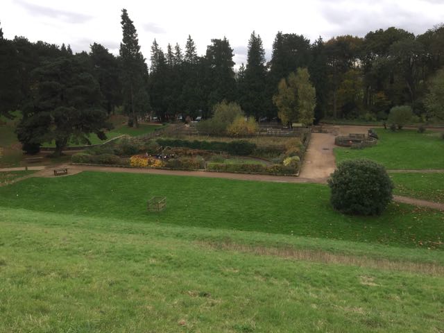
This is a butterfly and insect garden

On the way round we chatted to a man aged 90, who was out for his daily walk. An example to us all.

Wednesday, July 22, 2015

Hardwick, Sywell, Mears Ashby

Tue, 2015 Jul 21 10:06 AM BST
With Marta. Between 8 and 9 miles. Most paths fairly clear,apart from nr Hardwick Lodge Farm. Mostly arable or woodland edges. Warm, some cloud, some sun. Dry underfoot.
This is a very similar route to the walk we did on February 10 2015.
We started from the church at Hardwick, walked north as far as the right hand bend in the road, and took the footpath on the left, which leads northeast. At this time of year the footpath was clear, through the ripening wheat crop, over a coupe of fields, and led us easily to the footbridge over the stream. There was a clear footpath going uphill, and slightly right. When we met the hedge, though our route to the left was not so easy, so we followed tractor tracks to the next hedge and picked the path up as it went through the hedge. From here until Hardwick Lodge the paths were once again easy to follow.  Keep to the hedge until the corner, then go over the open field to the ruined brick building. Turn left, pass rusting machinery and continue through the field and round the small copse. Continue to the road. 
Hardwick Lodge advertises itself as the home of Happy Hens. Unfortunately we didn't buy any eggs - thought they could end up scrambled before we got home.

It's a little tricky to find the right paths around here - we ended up following the footpath between the fence and a stream round the edge of the property and over a footbridge, where dogs barked from the other side of a fence. At this point the path is unclear on the ground, but heads diagonally left over the field. We end up in the right place, pretty much at the corner of Hardwick Wood. Then we turned left towards Hardwick Short Wood. 
We followed the edge of the wood for about a mile, decided coffee was in order, then carried on to meet the road to Sywell near Wood Lodge Farm.
The stretch of road between here and Sywell is not very pleasant - a few hundred yards with no decent verge to walk along and fairly busy. At the Aviation Museum life gets easier as there is a pavement. 
In a short distance we cross the road and take the footpath left just before Sywell Hall. The footpath sign is invisible in the hedge from our direction.
that damned elusive pimpernel?
The path behind the houses and the hall is short and soon turns left at a small road. Today we followed the path alongside the hedge inside the field. This meets the path we need to take, turning left again and slightly uphill to this very pleasant bench. A sip of water and a couple of minutes of relaxation are not to be resisted.

Paths are again made good and easy to follow at this season. We cross one small section of field and another long one, downhill to a wooded stream, over a footbridge and up gently towards Mears Ashby. We meet Glebe Road, and decide to turn left and walk the short mile to Beckwith's Emporium and garden Centre to pick up sandwiches.  While we're there we are treated to an aerobatics display from nearby Sywell Aerodrome.


Our change of route means a stretch of road walking along a fairly busy road. We turn right and it's just over half a mile before we meet the footpath. We take this path to the left, and follow the hedge.  The path goes to the left through the hedge, and divides into two. We take the right hand one, which crosses a bridleway (this can be a bit tricky, but the route goes along to the corner of a field). The path carries on and turns slightly right heading into the village of Hardwick.

A few slightly tricky sections here. 

Tuesday, February 10, 2015

Hardwick, Sywell, Mears Ashby circular

I decided on this walk, as we hadn't done it since 2013, when Barry led it for us. It's at least 8 miles, but felt longer because of sticky, muddy, recently planted fields. OK, maybe nearly 9 including occasional rerouting around fields. Beautiful weather, and very little wind today.


We set off from Hardwick church
Take the road opposite the church, and when it bends to the right, take the footpath going off to the left. This heads away from the track and alongside the hedge. In the next field, keep walking in the same direction until you reach a footbridge over a stream. We walked uphill with the hedge on our right, and when we reached the next field boundary turned left, keeping the hedge on our left.
 When we reached the end of the hedge our true path was directly across the recently ploughed field, to a marker near a small ruined brick building . Horses and people had gone before us around the field edge, so we decided to follow - the going was not easy, but easier.

We've already diverted round the edge of a large field to avoid mud! Onward toward Hardwick Lodge.
 We met the path at the point in the photo above, marked by some rusting machinery. We followed the route over the field and round a small copse with a pool, and came out at the road and a junction of paths near Hardwick Lodge, which sells eggs, and is well protected by dogs, who barked until we clearly showed that our intentions were honourable. The footpath has been routed round the edge of the properties. 
Now the path goes towards Hardwick Wood, turns left and makes for the corner of Hardwick Short Wood. We follow the edge of the wood, as it becomes Sywell Wood and then continues behind Wood Lodge Farm to meet the road into Sywell.
A left turn and a short section of road walking with no verge takes us past the Aviation Museum and some industrial buildings. Just before Sywell Hall our footpath turns off on the left - the sign was obscured from our direction, so involved a few yards of retraced steps.
The path soon comes out on a small road. Turn left here and before long left again to pick up the footpath to Mears Ashby. It goes uphill to a bench, before heading diagonally and downhill over a field towards Sywell Bottom. It may be possible to go further to the right and pick the path up. We went through the trees - see picture below!
Time to practise our limbo dancing? Near Sywell Bottom.
 Next we turned right for a short distance, then left to climb gently towards the village of Mears Ashby. Here we followed the road past the school, and through to Highfield Road.
Mears Ashby dog - the quietest one we met today.
 The path goes to the left from Highfield Road, just where the road bends to the right. The next big fields were pretty sticky - we ended up with extra boots, made of mud. Heavy workouts for the legs. Even after crossing the Sywell to Hardwick road, the going was - soft?  At one point we wandered slightly from the official footpath, by following the hedge. Luckily the magic machine showed us what we needed to do, and we were soon back on track and heading back to Hardwick. 
Very large snowdrops - or a vey small tractor? I think the leaves are a giveaway.

Another crocodilian

Still smiling after all I've led them through today!
Map and details

Friday, September 6, 2013

Northampton Round 2 - Sywell Country Park to Castle Ashby


Wed, 2013 Sep 4 10:19 AM British Summer Time
With Marta. Very hot weather. Quite undulating. 7.5 miles then almost two more walking round Castle Ashby Gardens.


From Sywell Country Park we turn right and take the road uphill past East Lodge Farm, where the footpath is clearly marked.  We cross fields with horses, then the path crosses a line of trees and comes out on the A4500. 
We turn right along this, and soon left towards Ecton, on the quiet Wellingborough Road.  Ecton is a lovely village, with a large church, and attractive ironstone cottages.
The war memorial


  Benjamin Franklin visited in 1758 in search of his ancestors' graves.


Our route takes us along the High Street and towards the end we turn right onto a small path leading to West Street.  At the end of this we turn left, and walk south along a footpath.
The footpath joins a road, and we continue south along the road which goes above the A45.

Just after the bridge we turn left, or east,  along a byway - as the Northants Round instructions warn us, quite a lot of junk has been dumped here.   So much so that we missed our turning at first. Just before a gate you turn to the right away from the dual carriageway, and head south once more.

The bushes are covered in sloes and then haws as we approach fishing lakes and irrigation channels, and finally the River Nene. 


We have a break sitting on the bridge looking towards Cogenhoe Mill Lock.  The cows and bull obligingly move away from the pathway.  I think they're used to people from the caravan site and boats.


We have walked this way before


The church clock still stands at the wrong time, though it has moved in the two years since I last took its photograph.

We soon leave the short section shared with the Nene Way, and at the Royal Oak pub we turn left and downhill on the Whiston Road. 
Near the bottom of the dip the footpath is on the right, and leads south eastwards. 
 We walk along the hedgerow, under electrical power lines and follow the edge of the woodland.  Our instructions tell us to make two ninety degree turns - we manage the first  (to our right) and overshoot the second (to our left).   This adds a couple of hundred yards to our route, but we find the steps down from the embankment.
Jerusalem Steps, I presume.
The steps take us down to the bottom of the quarry, out of the woodland, then across a field and a track, and over a stream.  We turn right then slightly left to follow a track south east to the Denton to Whiston Road. We continue south east, through a short stretch of woodland and more fields to arrive at Chadstone Lodge.   On the small road we turn right and walk along to the tiny village of Chadstone. There a man and his daughter have been collecting plums, and he sings the joys of living there and foraging. "You can get a coffee . . ."  No he's not offering us one! " . . .at Ashby" he calls as he goes into his house.

We join the Castle Ashby Road, and walk the mile or so back to the car.  We take in the "rural shopping yard", fortify ourselves with tuna baguettes and cold drinks, and then explore Castle Ashby Gardens - £4.50 for us oldies, but a lovely place.  Lucky Marquess of Northampton.
Castle Ashby House with Latin words around the "battlements".

See next post for a few photos of the gardens.
Map and details


Sunday, August 11, 2013

Northamptonshire Round - NR 1 Holcot to Sywell Country Park


Fri, 2013 Aug 9 10:29 AM 
With Marta. The footpahts in the first part were not very clearly marked, but manageable with map. Downpour before we started, but fine rest of the day. Just over 7.5 miles.


Marta and I were a little stumped for our next long-distance walk. This is close enough to home, and only 51 miles in all. We'll visit areas that I don't know,  south of Northampton , and some more familiar territory on the way. 


Clear and detailed instructions for this section are on The Ten Foot Club website.  We seem to have walked an extra mile!   The Ten Foot Club are the guys who set the round up.


Miss out the next paragraphs ** to ** if you don't want to read my grouses!

**We didn't get off to a great start - I was grumpy after yesterday's disappearing footpath experience, Marta was a bit tired.  We were going to park at Pitsford reservoir by the dam, but just as we got there the heavens opened, so we diverted to the Visitor Centre for a coffee, foolishly assuming the parking tickets would be transferable. 

More grumpiness when we discovered that the café doesn't open until ten, and the tickets are not transferable.  Luckily we can always produce a black coffee from our portable coffee stop kit, and we decided to give Pitsford Water a miss - we've been there so many times already, anyway. So - we started our walk from the village of Holcot!**


Holcot church

The phone box has a new use
Just opposite the church and phone box book exchange is a footpath between the houses. There is even a NR sign, so we walk through the passageway, and then turn left and downhill along Poplars Lane to Walgrave Road. Here we turn right and on the corner there's a footpath sign leading us through a gateway guarded by two eagles.

The way is not very clear, but turns sharp left at the gates and follows the field boundary for a couple of hundred yards. There is a footbridge, but it's overgrown and people obviously take an easier route round the culvert. 
Then the path goes uphill diagonally. We went a bit too far to our right, and had to correct our route.  Some of the field boundaries may have changed since the OS map was last revised.  Another case of "clear on the map not on the ground".


Our route may be not quite right, but we either follow field edges or footpaths, and manage to get ourselves on track again.

For a short distance the way is clear and we meet the bridleway which leads us to the A43 - which we have to cross.  We turn left along the road for a hundred yards - a closer look at the map shows we should have turned right and found the footpath in the layby. No matter - we use a wide bridleway leading toward Hardwick Lodge, and then turning to the right towards Hardwick Short Wood and Sywell Wood.  Once more there are footpath waymarks and NR ones too.
A friendly fence repairer.
The path comes out near Wood Lodge Farm, and when we reach the road we turn left and walk the rather busy quarter mile or so to the turn off for Mears Ashby, on the Beckwith's Emporium Corner. A quick wander through there - but we decide it's too busy and too posh for today, so make our way to the village. This road is very quiet once you pass the Emporium!  
Our route takes us round the village - a pretty one - and we stop for a sandwich at the Griffin Inn.
The rest of the route is straightforward - the footpath goes off to our left after Mears Ashby Hall. After a short wooded section near the wall it heads southwest, slightly to our right, across a large field to the Mears Ashby-Earls Barton road.  The gap in the hedge is a bit overgrown and the road's a bit busy, but it's a short distance to the path on the other side.
From here it's plain walking and gently downhill towards Sywell Reservoir and Country Park.  Seven a half miles in all.

Wildlife spotted: one hare, quite close by, and a buzzard circling and mewing. Lots of butterflies.

Map and details


Tuesday, June 25, 2013

Sywell circular via Mears Ashby and Hardwick.


Mon, 2013 Jun 24 9:46 AM British Summer Time.
Led by Barry, with me, Eddie and Gordon. A dull morning, mostly dry underfoot. Not hilly, through arable land and villages. 9 miles.

The walk covers the same ground as this one, but starting in Sywell rather than Hardwick.  
Sywell church
From the church we turn east along the road towards Mears Ashby, ignoring the first footpath sign to our left, which leads between houses.  
Our path is off to the left, just as the road bends round to the right. 
The path crosses the corner of the first fields, and in the second one heads for the far right hand corner. It snips the corner of the third field, and in the fourth goes down to cross a stream.  Then we head almost due east again uphill to join Glebe Road going into Mears Ashby.
Too early for today's break
We follow the road on the north edge of the village and turn left at Highfield Road. In a short while the path goes left, heading north now.  After four fields we meet the Sywell to Wellingborough Road, and cross it.  We cross two fields, then come to a dividing of the ways - we take the right hand path - or head for the high ground.  Don't get skylined, advises Barry in ex-army mode.   We pick up the path and make for Hardwick, via farm buildings and houses.  We turn right along the road to the church, then left, and find our path off to the left as we come out of the village.
We're still going north, over a couple of fields and then a bridge over a stream.  At this point we decide to follow the field boundary since the path hasn't been made good.


When we reach the low ridge we turn left, going west.  It's fairly windy at this point and we pick a spot sheltered by the hedge for our break.  The path hugs the boundary until we reach a large open field - here we continue west straight across the field.
At the hedge we turn left - there's a small ruined building on the other side of the hedge.
South now.  In the second field there's a pool surrounded by trees - the path circles this - we choose the right hand route. 
We arrive at a very small road, and the dogs of Hardwick Lodge.  The people are friendly, and c hat a while, before suggesting we take the diverted route which is marked, and wishing us good walking.
We follow the path on its slightly devious route, eventually walking alongside Hardwick Short Wood and Sywell Wood.  We come out at Wood Lodge Farm, and meet the road into Sywell past the airport and the Aviator Hotel.
A quick look at the map
flying the flags
Just before Sywell Hall we take a path to our left, which brings us out at the footpath we ignored on the way out.
Sywell geese
Map and details


Monday, March 11, 2013

Hardwick-Sywell-Mears Ashby-Hardwick


Mon, 2013 Mar 11 9:41 AM Western European Time 
Led by Barry. With me, Gordon and Maureen. Cold weather, strong wind. sunny at times. almost 9 miles in all.

One of those shall we /shan't we days.  Snow flurrying about, car windscreen and doors iced up, but the promise of sunshine too.   No more than a few minutes behind schedule we set off to Hardwick and parked near the church.  
Into the teeth of the icy blast - after five minutes, I decided I needed my waterproof-windproof layer on top of the three I already had. 
We headed north along the road out of the village, and when the road bends to the right, we took a footpath to the left.  It leads to the opposite corner of the first field, and then across the next field. We ended up slightly too far over and had to walk back a few yards to the gap in the hedge, and footbridge over the stream.
The route across the next field was clearer, and at the next hedge we turned left following the field boundary west, past one hedge, then across another field. We met a bridleway, and turned to the left, going south. 
As we reached the minor road near Hardwick Lodge, we were greeted by barking dogs - in an enclosed area.  The easier path here turns more or less west down the lane and skirts the grounds of this house and others.
We turned southwest to meet the corner of Hardwick Short Wood, and followed the edge of this wood, and then Sywell Wood.  After passing Wood Lodge Farm we met the Sywell Road, going past Sywell Airport and Aviation Museum.
Exhibit 'A'


Exhibit 'B'

Exhibit 'C'

Barry had half promised us there'd be a coffee shop, but apart from the Aviator Hotel, we saw none.

Just before the main village we took a path to the left, walked for a short distance along the road and then turned left again, and slightly uphill.  At the top of this field there was a seat, but we preferred to choose a more sheltered spot on the other side of the trees - not quite the comfort of a café but not bad in the sunshine. 

Onward and down to the stream, then up again and across to Mears Ashby. 
How about this for a guard dog? No need for walkies, either.
Along the road east as far as Highfield Road, we turned left and then along a footpath heading north.  This continued over farmland, then across the Wellingborough to Sywell Road, then more farmland.  Some of the fields were pretty sticky, even though there was still ice on top of the puddles.
Almost done!


We crossed another path, but carried on north before the path turned slightly northeast and back into Hardwick, past a farm,  and a few houses. We turned  right and were back at the car.  Cold, muddy in places, but satisfying.


The map is in two parts - technical "issues".