and occasionally rides a bike.
A word of warning. The walk descriptions are not detailed enough to guide you - please take a map. The batteries never run out, and you always have a signal. Oh, And don't take left or right as gospel!

Showing posts with label California. Show all posts

Friday, September 15, 2017

Lafayette-Moraga Trail by bike

I've walked some of the way along this trail before, and have always fancied cycling it. This year we were able to borrow bikes from the place we stayed, and so accompany Leonie, Brian, Eilidh and Aneurin.  

We rode from the entrance near 4th Street as far as Moraga Commons and back again - a total of around 12 miles of easy cycling.


The trail corridor has a rich and varied history. This trail was once used by mule trains to carry redwood from Oakland to Sacramento. Later, when the mule trails had passed into history, the lumber was carried by steam trains, including the Oakland-Antioch and Eastern Railroad, the San Francisco-Sacramento, and the Sacramento Northern, for which the easement was historically named. With the abandonment of the railroads the corridor became a utility easement, and, ultimately, with the cooperation of local communities, utility districts and the East Bay Regional Park District, a paved multi-use recreational trail was established serving hikers, bicyclists, and equestrians. 
from  Rails to Trails.


It was a very pleasant way to spend an afternoon.

Monday, September 11, 2017

San Fran meanders 2 - Land's End

Friday 04 August 2017.  With Harry, we discovered another part of the City. We took a couple of bus rides out to Land's End, and had a picnic lunch from the Visitor Centre Cafe before walking some way along the Coastal Trail. It was not warm!


Part of the development by Adolph Sutro, from the 1880s. This included Cliff House, the gardens at Sutro Heights and seven swimming pools at Sutro Baths. It did not look enticing!
The fog is creeping in over the sea. 
Not so Golden.

The flowers added some colour to the day.

 The Labyrinth

We made our way back to a bus stop not far from Lincoln Park. 

Sunday, September 10, 2017

San Fran meanders 1.- Bernal Heights

Out of chrono order - we were in San Francisco for three nights before heading to Lafayette to visit the family.
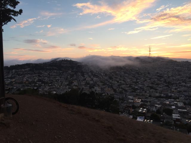
Our evening stroll for those evenings was up to Bernal Heights Park from the apartment near Precita Park - just under a mile each way, with over 400 feet of climbing and descent. But what sunsets and what views of the city and the bay, with the evening fog rolling in.   Full of photographers, naturally.


Carquinez Strait Regional Shoreline and later Mount Diablo

12 August 2017 - another short hot, but less strenuous wander near(ish) Lafayette. 

We followed the track for a there-and-back walk of just under 5 miles. The track runs alongside the Carquinez Strait, but between 100 and 200 feet above sea level. This is near Martinez. We were rewarded with views of a ship being guided in by tugs, and trains on the railway line some way below us.

Grabbing the shade while we can!

Serious discussion


The strait


Quite late on, we realised it was peak time for the Perseids and Mount Diablo Astronomical Society had an event on Diablo, so we dashed east to see a fabulous sunset, but not many meteors.

A 'Brocken Spectre' effect - the shadow of the mountain cast on the incoming fog.


Quite a day!

Las Trampas, EBMUD

9 August 2017, 5.3 miles, though it felt further.

Quite a view
A short hot and strenuous walk in Las Trampas Regional Wilderness, in the East Bay Regional Park District.  For part of this walk you should have a permit from EBMUD (East Bay Municipal Utility District).
Great views, but not a lot of shade, and very dry when we walked it with local residents, Leonie, Brian and family.

Photographer at work

Hello, lizard!

The route

Over 1000 feet of climbing.


Sunday, December 6, 2015

Catching up

We've been away again, in sunnier climes, visiting family, and doing some familiar and some less familiar walks.

A few city walks in San Francisco, which is not a flat place.
View of the city from Buena Vista Park


Several walks around the reservoir in Lafayette - the shore trail is 2.7 miles long, and fairly flat.
Lafayette reservoir

from higher up

This is what Leonie calls "heart attack hill"


The rim trail is five miles long and involves climbing around 800 feet, some of which is exceeding steep.

A gopher snake basking in the sun


View over the bay from the high point of the Nimitz trail

We also walked with Brian,  Leonie and the children along the Nimitz trail at Tilden Regional Park, where there are wide views over the Bay area.

And I walked from Moraga to Lafayette along the walking and cycle trail - again around four miles, and fairly flat.


Saturday, September 20, 2014

Sibley Volcanic Regional Preserve

Friday 19 September 2014

A little under five miles of gentle walking, on clearly marked trails helped by the free leaflet at the trailhead.


We followed the volcanic trail, not completely in order, as it led us round the park, educating us about the formations in this part of the East Bay area. The tunnel and freeway are out of sight most of the time.

There were birds of various kinds, from Steller's and other jays, to some so far unidentified by us, small bold black-headed birds, and this one seen on a bush nearby,  possibly a female lazuli bunting or a female western bluebird . 
There were birds of prey hovering around, being mobbed as usual by smaller birds. One flying like a kestrel.

Butterflies, white and coloured, large and small, the scent of eucalyptus, pines and in the open areas anise.

Lizards lounging deckchair less along the side of the old Quarry Road - a favourite basking spot.

Grassland dried out and gone to seed. Two 'labyrinths'

Distant views of Mount Diablo and the Bay. the freeway not too far away, but hidden.

The last section of the walk back was blissfully shaded.