and occasionally rides a bike.
A word of warning. The walk descriptions are not detailed enough to guide you - please take a map. The batteries never run out, and you always have a signal. Oh, And don't take left or right as gospel!

Saturday, June 28, 2014

alirides - the sequel: to the Hardy Monument and back

Set off about 10 am on Friday 20th June 2014. The route was almost entirely on National Cycle Route 2, apart from the odd diversion.  Total mileage just short of 40 miles. Hot and sunny again, and over 2 000 feet of uphill. 

By the looks of this first photograph, I could have settled down to an idle day! 
From Stoke Mill, near Broadoak via Dottery, Bradpole and Loders.
The pub in Loders served us coffee just before they officially opened - most welcome and very friendly service.   
The bridge just outside Loders commemorating 1914.  We diverted slightly into Uploders before following the road towards Shipton Gorge - not a gorge at all, though it has hills.
We had views of the sea from the higher ground.
We eventually met the river Bride and the (reputedly) flat section of the route.
After following the river valley for some time we reached Litton Cheney and its pub the White Horse.  An excellent sandwich with trimmings and plenty of liquid taken on board here. Once more, very friendly service.
From there we rode to Long Bredy and Little Bredy.
I confess to a couple of pauses on this long hill, but I did ride up it.
Not much further now to the Hardy monument - not to the writer but the seaman of "Kiss me, Hardy" fame. Wonderful views all around from here.
A friendly walker offered to take our photo.
He had walked along the South Dorset ridgeway from Weymouth.
We could see Chesil Beach.
Harry in the landscape
Strip lynchets - remains of a mediaeval farming system.

The ride back was easier, as there was more downhill, and the wind was behind us.  All the same any climbs felt like very hard work.  Especially the last short one! 

Map and details

Thursday, June 26, 2014

West Bay, Bridport to Golden Cap and back

Wed, 2014 Jun 18 11:27 AM BST.  Around 10 miles. 1,600 feet of ascent. Glorious weather - sunny and hot.

We set off from West Bay.
West Bay harbour stalls

The mighty hunter brings apple cake

This is where we're heading

The cliff to the east

We follow the South West Coast Path uphill from the seafront, and head west.
The many seats are tempting, but it's early in the walk. 
Birds' eye view


The path climbs up, then descends into Eype, then climbs again towards Thorncombe Beacon.

Sheep with a personal shelter - of sorts
Not time for lunch yet, so on and down again, to Seatown, with its holiday camp, pub and shop - coffee time.
Our objective!

Onward and upward once more. The path has been diverted slightly inland, but is well signed.
Looking back
This section has some steep parts, and I'm getting hungry, but we carry on to the trig point. 627 feet high doesn't sound a lot, but we've climbed up from sea level three times to get here! It is the highest point on the south coast.

the view west to Charmouth and Lyme Regis

The view down
We admire the views - as far as Portland to the east, and into Devon to the west. Then it's time for lunch and a rest.

Back to Seatown and we reckon we've earned an ice cream by now. Then up to Thorncombe Beacon once more, and eastwards to West Bay.


A sense of achievement
A strenuous walk but well worth all the effort. And we carried the apple cake home, a little squashed, but still edible! 

Map and details

Cycling through Marshwood Vale and Charmouth

dTue, 2014 Jun 17 10:38 AM BST -
Activity Type: Cycling | - Just under 20 miles.

We used two leaflets from the cottage as source guides for this ride, much of which follows National Cycle Route 2.
and

Another day of superb weather - even sun cream weather. We ride up to the Shave Cross Inn, not open for coffee so early, alas!  This has been an inn for hundreds of years, but we learnt later that it is soon to close and become residential property.  
Whitchurch Canonicorum


From there we turn south towards Whitchurch Canonicorum, a place of pilgrimage to Saint Wite ( Saint Candida) - the only place relics of a saint survived the Reformation, apart from Edward the Confessor at Westminster!  Though I didn’t know it as we rode through, Robin Day is buried there.  It’s a magical place on a sunny day, full of trees and shady corners.
Charmouth beach


Then we head on to Charmouth, taking a direct route which involves crossing a main road just as we reach the town, which is just west of Lyme Regis.  A pause for a mediocre coffee and scone at the beach café - unfortunately there are only two outside tables, and both are occupied, so we don't get to admire the view as we eat.
St Mary's Catherston Leweston

From sea level the only way is up.  We cross the main road via a bridge, then ride up through Catherson Leweston with its tiny church next to the Manor House, then upwards and downwards to Wooton Fitzpaine, up through welcome shade of the forests before Coney's Castle, one of the iron age hill forts.
Climbing through the woodland
As the road climbs and we come out of the trees the views are spectacular.


Next we follow the road to Marshwood, past Lambert's Castle - another hill fort. On a cooler day we may have been tempted off the bikes to walk up, but not today. 
Just after joining the main road we stop at the Bottle Inn, famed for the Nettle Eating Championships held in early June. A very welcome drink and sandwich, and conversation from the landlady set us up for the remaining few miles.

We turn right and ride out past Marshwood church, another place with a remarkable view. Then a long descent and back past Shave Cross and to the cottage.  What an area!


Photos by Harry (apart from the last one).


Wednesday, June 25, 2014

Circular from Stoke Mill via Copper Hill - June 15 2014


A pleasant walk of almost six miles in all, including the false start. Grand views once we gained some height. Weather hot and sunny, and rather sticky in the valleys, so we decide on a gentle stroll . . . and I didn't take a camera. . .


It all looked so easy on the map, a named route the Monarch's Way, a bridleway between hedges. When we got there the bridleway was maybe passable for Puddleglum in wellies. Alas, even walking on the other side of the hedge was in vain as the barrier was dense and impenetrable.

We went for plan B, and took the public  footpath through Bucketts Farm - not simple even with the farmer's help. It involved diving under wire that may or may not have been electrified, talking nicely to some bullocks, and walking across a dried hard ploughed field.  Anyway, we emerged near Bluntshay Farm as planned, and decided to follow the road for a while.


We turned left, past Copse Hill Farm. Walking here was very pleasant, as there is little traffic on these narrow lanes. Shortly afterwards the road bent sharply to the right, and we turned left along the track to Purcombe  Farm. This track is marked "Private Road", although it is a public footpath.  Shortly after the sign our route turned right and we followed the track as it made its way uphill towards Copper Hill.


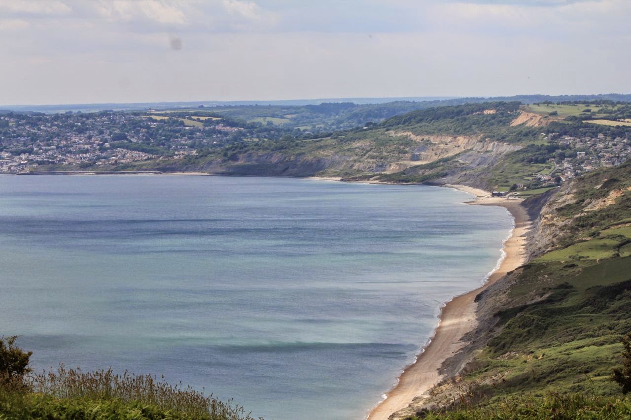
The views improved with every step, and the breeze was a welcome contrast to the humidity of the valleys.
There were some flowery meadows with butterflies too.


The path continued past the hill with the trig point at 157 meters, eventually turning left at a junction of ways, then leading downhill to Lower Denhay Farm.

A gruesome find

The road from the farm comes out at Denhay Corner House. We turned left at this junction and then walked along the small road for around a mile to the Paddock's Cross junction.


Most photos are Harry's.