and occasionally rides a bike.
A word of warning. The walk descriptions are not detailed enough to guide you - please take a map. The batteries never run out, and you always have a signal. Oh, And don't take left or right as gospel!

Showing posts with label Sutton. Show all posts

Tuesday, October 2, 2018

Yarwell Mill - Wansford- Sutton- circular

Walk from Yarwell Mill 01 October 2018. Around 7 miles.
With Maureen, Norma, Eddie and Kate.

Bright, but chilly!

We followed the Nene Way footpath from Yarwell Mill country park. It leaves the road just before the car parking area, and heads north along the edge of a field, past enclosures with horses and alpaca. 
It then goes left up to the road in Yarwell village, where we turned right. The footpath goes off again to the right at a bend in the road. We followed the path as far as the bridge at Wansford. We turned left along the roadside, then right towards the A!. Just before the road we turned right again to walk under the A1, with the river Nene visible on our right. The path took us past a picnic spot, and then continued along the road way, past more construction work. We passed near a lot of litter and there was a lot of traffic noise. They are making the A 47 into dual carriageway, so the path can be a little awkward  to follow, especially just after picnic area. Take the road until you see the footpath sign, then head towards the river. All of this may become very unpleasant as the work proceeds.
Eddie walks round the pitch under the morning moon
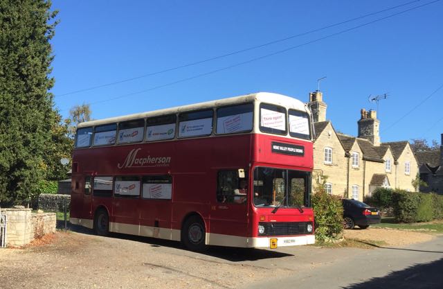
This bus, labelled "Nene Valley People Rising" was on its way to the public meeting in Wansford
https://highwaysengland.co.uk/projects/a47-wansford-to-sutton-dualling/


We followed the Nene Way to Sutton , and turned left then right past the church.
Irresistible autumn colours
We walked along Lovers Lane, and then took the Nene Way  footpath to the right across fields and over the railway bridge to Wansford Station.
There were crowds waiting for the arrival of the Flying Scotsman, but we decided to continue walking.
We turned right at the station and very soon took a grassy footpath on the right, next to, but not across a ploughed field into Sibbington. once there, we walked along the road to the left, which brought us back to the road to Wansford Station. A little longer but a pleasant detour.  We turned right, the very soon left to the bridge over the A1. All of this road walking had either a proper footway, or a very wide verge.  We followed this road west until it joined the B671. A left turn here and before long we saw the bridleway sign on the right.
We took the bridleway slightly downhill and clearly marked, with a fishing area and lake on our right. At the junction, there are large boulders and to the right the entrance to the fishing lake. However, the bridleway continues ahead. Ignore the fishing lake gate.
Soon after this the bridleway as a "No entry" sign. This is for vehicles. The bridleway sign is nestled secretively on a post to the left!  It continues behind Yarwell Junction and on to rejoin the Nene Way, just after a bridge.   Here we turned right to return to Yarwell Mill.
We stopped there for a decent and reasonably priced sandwich and drink before going home. 

The first crossing of the A1 is an underpass, the second a bridge.

Friday, September 28, 2018

Nassington-Yarwell-Wansford- Sutton

No route descriptions here - it needs working on.
With Maureen - 8.5 miles.

So a fine day, and a few photographs!
River Nene


Near Yarwell Mill

An early coffee break - too tempting


alpaca


Wansford Bridge

This notice has been here a while

I had just said - pity there aren't more seats!

St Michael and all Angels, Sutton

We've been here before

Sky divers

Convenient seat again!

Thursday, June 14, 2012

Sutton - Ailsworth - Ferry Meadows

Open bell-tower at Sutton


If you can't live in a castle . . .

'Antique' way marks


Thorpe Lodge - beautiful, but there's a lot of traffic noise!
Gunwade (?) Ferry Bridge
Footbridge near Castor Mills
Castor Watermill

Nene Valley Railway
Water Newton Weir

Towards Wansford Station 
Close to the Nene we saw a green woodpecker - it flew up from the ground showing off its yellow rump, calling as it flew in typical green woodpecker fashion.

This walk covers some of the ground I walked on September 23 2011

Map and details

Friday, September 23, 2011

Nene Way 9 - Wansford - Ferry Meadows

10 miles. With Marta. Sunny, warm, delightful weather.


From Wansford we took the road opposite the church which leads towards the A1.  Just before the road the path turns right and goes downhill towards the river underneath two huge bridges before making its way up towards the A47, past a lorry park, then turning right behind the petrol station along a path through fields. For a while we walked parallel to the road, then following the curve of the river turned south-east. We joined a wider track (a dismantled railway) but followed it a bit too far into some stables.  Quick question and we were set right - we'd missed the signs on a kissing gate next to a field gate! The path led us into the village of Sutton - (Sutton Only as the signposts from the road tell us), past playing fields, houses and the church with its open bell tower.  Then we turned briefly west, and south across more fields towards Wansford Station, the headquarters of the Nene Valley Railway.


A quick coffee stop and nose around, and we were ready for off.

The station and railway have been used in lots of documentaries and other films and there are plenty of events.


The Nene Way runs alongside the railway for half a mile or so, then moves further south towards the river, crossing fields full of Roman remains, which are not visible as anything other than humps and bumps.
Water Newton

Roman remains?

The path follows the river but turns sharply left to negotiate a meander just before Mill Hill - a noticeably higher piece of ground.  We crossed a footbridge, where we saw this orderly family of swans.


 After the bridge we followed the higher ground round to the road down to Castor Old Mill. There's a water mill and remains of a windmill. 

There is a ford and a footbridge over the mill arm of the river (Back Dike). The Nene Way crosses the bridge and turns left following Back Dike, crossing another footbridge and then walking with the main Nene on the right.  A clear path leads us under a railway bridge (Nene Valley Railway) and into Ferry Meadows. The Cycle hire and Canoe centre is across Gunwade Lake.


We continued past Ferry Bridge and along Ferry Walk Path to finish at Green Cafe near the Ferry Meadows Visitor Centre. 


Wildlife - herons, grebes, geese, green woodpeckers (we heard more than we saw). Fish - no idea what sort.


Map and details