We left Braybrooke from the road opposite the church. We parked on the grass at side, just by a footpath sign, which takes you over a stile on the left. We crossed the meadow diagonally, disturbing some of the cows which were lying down, to a point where we crossed the railway line. We continued to climb gradually crossing several arable fields, some with corn, and some which had been harvested recently, then more steeply to reach the A6. We had to walk along this road for about half a mile. First we were welcomed by a sign into Leicestershire, the heart of rural England. Soon afterwards we walked along the verge to a lay-by, full of trucks and a snack bar, and the smell of bacon butties.
Shortly after the old Kettering Road from Harborough joins the road from the left, we turned right on another footpath. We followed this down hill and to the right along the side of a hill, just touching the edge of Dingley Warren wood, before making uphill for Dingley Lodge Hotel, on the main Corby-Harborough Road.
 |
| Mud sticks to boots |
 |
| Trust you to take a photograph now! |
You can see from the photographs that the view would be pretty good on a clearer day, but those fields were hard work, as our boots grew heavier with every step.
We walked up to the road, and followed it to the right into Dingley. After a short distance we turned left on to a small residential road which leads to Dingley Park. A short way along this we turned right, past some stables and a dressage area, then continued through fields and short paths through hedge boundaries until we crossed a wheat field with a clear wide path, which took us to the Corby- Harborough Road again.
The weather was starting to look even less friendly by now, so we had our snack break, before walking a short distance towards Brampton Ash, and taking a footpath to the right.
So . . . behind the church, and Grange Farm, which now has a picture window extension with views over the valley, and out to the quiet road downhill.
The road turns to the right and a little further on we took a footpath to the left, leading down to farm outbuildings called 'Red Hovel' on the map. A quick google shows that 'hovel' can mean an open outbuilding for storage or for the use of cattle.
Next we climbed up to the ridge, where we turned right aiming for the edge of Hermitage Wood. If there was a hermit, he was keeping himself very much to himself today - well out of the rain, I imagine.
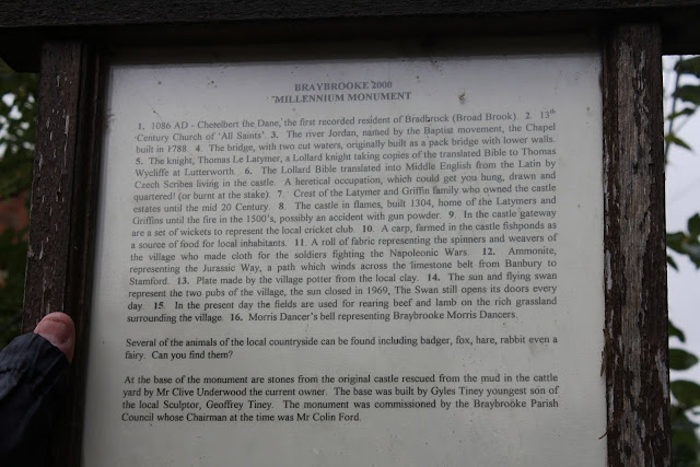
We rejoined the minor road at a settlement called Hermitage Cottages, close to a roundabout on the A6. We followed the footpath (Jurassic Way, Mid-shires Way, and Macmillan Way),through two large fields of wet beans to Braybrooke Lodge - another farm with several horses and foals and a dressage area. Across the minor road, over stiles and underneath the railway line before making our way across the fields and back into Braybrooke, past bumps in the fields which are the remains of a castle, which was built in 1304, was the home of the Latymers and Griffins, but was destroyed by fire in the 1500s.
 |
| Braybrooke's Millenium Monument We learnt something of the history of Braybrooke from the Millenium Monument and the information board near by. |
Map and details


No comments:
Post a Comment