The long distance path starts from the northern end of the harbour, and goes up steps to the Portpatrick Hotel, then an old BT building and the golf course.
 |
| Looking down on the end of the old railway line. |

 |
| Be careful about that 'evasive action'! |
 |
| Port Kale and Port Mora where Dunskey Glen meets the sea |
 |
| The Coastal Interpretation Centre - though no one was interpreting today. |
 |
| There are a couple of sections with steps and handrails |
 |
| Tormentil and spring squill |
 |
| To the Lighthouse - privately owned, so no coffee here! |


"The lighthouse was built in 1900, although the dangerous crosscurrents have still caused some shipwrecks including that of the Craigantlet, a container ship which ran aground in 1982 - the remains can still be seen in the bay below."
 |
| Looking away from the sea, this could almost have been Derbyshire. |
 |
| An orchid...? |
 |
| ...and another one? |
 |
| Down the steps |
 |
| A cove |
 |
| and a cave |
 |
| Looking down into Portpatrick |
 |
| The route |
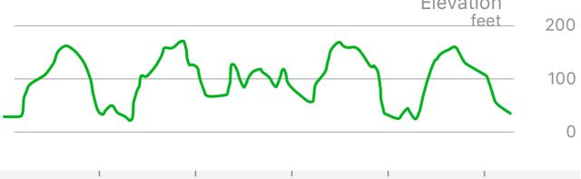 |
| And it wasn't flat. |
2 comments:
Well done and nice photos!
Thank you - it’s a fabulous area.
Post a Comment