"We take our name from the famous cycling Mountain, Mont Ventoux in France, which has been featured in the Tour de France since 1951."
The walk covers much of the same ground as this one.
We set off turning right away from the A47, and after a couple of hundred metres we turned right along a track signed as a bridleway, heading east towards East Norton. We followed this at Little Gunsel. At a junction of paths we continued ahead through more woodland (Hardy's Gunsel this time), with a hedge on our right. At the next junction we took the right hand path, heading southeast, crossing a small stream.
There's another meeting of paths and at this point we caught sight of East Norton Hall through the trees.
We turned very sharp left, slightly west of north, taking a freshly marked (weedkilled) path over a field and down to a footbridge, marked on the OS map as a ford. We kept the hedge on our left and walked uphill to the remains of Loddington Mill (just a base as far as I could tell), then along a cart trackwhich bent round to the east toward Loddington village. In the hedge on our left is a stile and a path to Loddington church - conveninet bench here for a break.
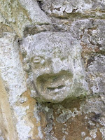
Carved heads old and newer.
We went back to investigate the disused railway line - there's a permissive path heading south, but no clear access to head north. We met a woman radio tracking nesting pheasants for the Game and Wildlife Conservation Trust which has a project nearby.
We decided to follow the path by the church to the village and the road which turns left, then left again at Oxey Farm along Wood Lane. About a mile further on, at the bottom of a hill, we turned left on to a footpath by the Eye Brook. We crossed the stream - again the map marks a ford, but there is a bridge.
We climbed gently along a wide track towards Skeffington Lodge Farm, and couldn't resist another pause for a drink.
 |
| Time for a selfie! |
 |
| Typical scenery and sky |


No comments:
Post a Comment