Fri, 2013 Mar 1 9:30 AM Western European Time
With Marta. Section 3 Leics Round + a bit. Pleasant weather not warm, not sunny, not cold, not muddy. 9.3 miles, including detour for pub lunch at Claybrooke Magna.
Another grey day, slightly damp to start
with. I drive over to Sharnford, and
manage to squeeze my car into a parking space, then hop into Marta’s car and
make for Frolesworth.
We find the sign for the Leicestershire
Round and walk along the track, then miss the next sign completely. OK, we haven’t seen each other for three
months and there’s a lot to catch up on, but we really ought to keep our eyes
open.
The long and short of it is that we miss
the clearly marked route, and head off west rather than south. It doesn’t even register when we reach Fosse
Meadows Park, which I know is near Sharnford.
We think we’re doing fine when we see Leicestershire Round signs, and
follow them happily – emerging in Sharnford.
We’ve walked two miles or so.
Good job we decided to do a short walk
today. No problem – we’ll retrace our steps and pick up the route in the
opposite direction from the one we first thought of.
Fosse Meadows has a car park and picnic
tables, and is a popular dog-walkers’ venue.
By the time we get back there we declare coffee time. It doesn’t take long to chill today, so we
walk out to the road which is unsuitable for motors – this is the old Fosse Way
and takes us right up to High Cross – the point where the Fosse Way and Watling
Street (the A5) meet. It’s also supposed to be the Centre of England. Interesting article on the link -
There's a fair amount of info on here.
This monument was erected in 1712 by the Denbigh Family "in grateful as well as perpetual rememberance of peace, at length restored by Her Majesty Queen Anne 1712" It is Grade II listed and was struck by lightning in 1791.
The Latin inscription translates as 'If Traveller, you seek for the footsteps of the ancient Romans, here you may behold them, for here their most celebrated ways, crossing each other, extend to the utmost bourne'
We’re still following the LR markers
without any problems until we reach a
footbridge over a stream. The marker is there, and there’s a well trodden path
across the field leading slightly to the right. We follow – who wouldn’t? The next marker has no LR symbol, but instead
says “Parish Walks”. Suspicious. Hmm Sherlock, what d’you reckon? It’s as well we know other people have got
lost around here. Serious discussion,
consulting of maps, working out that the A5 looks altogether too close. We hesitate – go forwards, back, turn left?
After a couple of false starts we turn left along the field edge, and
eventually find another LR sign, near a house called Midsummer Barn. From here the markers are clear – all the way
to Claybrooke Parva school. We rescue a
football, which the kids have ejected from the playground. An eight or nine-year-old asks us “Are you
explorers?” “Sure thing” I reply.
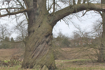
Then a right turn along the road, past a
twisted tree in a field and we pick up the path again.
At Claybrooke Magna we detour for a few hundred yards to the Pig in Muck pub. We leave our mucky boots outside. The pub does a decent baguette with salad and chips, plus tea or coffee for around £7. There are plenty of customers today.
At Claybrooke Magna we detour for a few hundred yards to the Pig in Muck pub. We leave our mucky boots outside. The pub does a decent baguette with salad and chips, plus tea or coffee for around £7. There are plenty of customers today.
We make our way back to the route. It is beautifully marked, and takes
us past Hill Farm. There is a row of freshly painted yellow posts here. The man who's just painted them shouts to warn us of wet paint! There's no way we can go wrong here. Magic! It continues like this all the way to
Frolesworth, and we can’t understand how we missed seeing the markers this
morning! We look back and the route is really clear.
Map and details of the walk


No comments:
Post a Comment