8.8 miles. One unintentional detour turned a mile or so of the walk into the A45 Way. Just about ok if you were cycling, but noisy and unpleasant for walking. Dry, fine, no sun today.
Lots of birdlife today - from terns hovering and diving, to several families of swans, moorhens with big-footed chicks, coots, a heron, and a flock of goldfinches taking off from a patch of teasels. Canada geese flying in a mob - how does an individual goose decide whether it'll join those on the wing or stay with the gang on the ground?
We started from Sixfields, crossed the road to Duston Mill Lane and walked down to the disused Mill and the path by the lakes of Storton’s Pits Nature Reserve. We saw terns hovering above the water and diving in – but my photographic skills weren’t up to capturing them, alas. `
 |
| Express Lift tower - the 'lighthouse' |
The Express Lift Tower, otherwise known as the ‘lighthouse' is visible on the left for a large part of this section of the walk. The area is left to grow pretty wild, and is an important wetland habitat
 |
| Chicory? |
As we walked we noticed that the ‘lighthouse’ appeared to be on our right – we had walked round the end of one of the flooded gravel pits and missed a left turn where the Grand Union Canal Walk joins the Nene Way. As much by luck as judgment we found the Canal Bridge where the Nene Way doubles back at a right angle then over a bridge with iron rails across the river and then turned right to walk under the railway viaduct.
The path continues at the back of a shopping centre, then under the A5123. At the Carlsberg brewery, with its silos, the path turns to the left and then back on the other side of a short channel. There is a bridge, and the banks have several large willows.
 |
| Looking over the Nene from behind the Carlsberg brewery |
Shortly after this there is a long high wall which forms part of the flood defences.
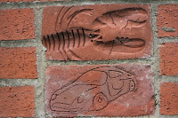
These decorative bricks are part of the flood defence wall in Northampton.

 According to the plaque 'Local children from Delapre Middle School engraved the bricks using both the local environment and the celebration of the Queen's jubilee year as their themes.'
The plaque shows some of the industrial history of the Nene, and its importance as a commercial waterway, along with the nearby Grand Union Canal.
The Nene Way then goes into Beckett's Park
We followed the path over a footbridge and through the Barnes Meadow Nature Reserve and site of the Battle of Northampton in 1460
The path brought us to the Bedford Road, and what I imagine is part of the Nene Whitewater Centre.
 |
| Bedford Road water control system - is this linked to the White Water centre? No one there when we walked by. |
Just after this point we were diverted/distracted and followed signs for Billing via the cycle path. A mile of the Nene Way we hope to come back to - away from the heavy traffic noise and smell of the A45!
 |
| A welcome sight after our detour along the cycle path and through the shopping park. |
 |
| A fine avenue of beech (?) trees in the area behind Riverside retail park. |
 |
| moorings and huts along the river |
 |
Approaching Billing Aquadrome - spectacular gardens for mobile homes
Back to base . . .
A photo taken last week. Behind the pub at Billing.
Map and details
|


 According to the plaque 'Local children from Delapre Middle School engraved the bricks using both the local environment and the celebration of the Queen's jubilee year as their themes.'
 According to the plaque 'Local children from Delapre Middle School engraved the bricks using both the local environment and the celebration of the Queen's jubilee year as their themes.'


No comments:
Post a Comment