Thu, 2013 May 23 9:46 AM Western European Time
Led by Barry, with me and Gordon. Track walking, then riverside. Clear paths, very flat, dry underfoot apart from a small section in Portholme Park. Just over 9 miles. Weather mostly dry, some sun, a couple of showers. Cold wind. Coffee and a toasted teacake in Godmanchester.
Photos taken with Fujifilm FinePix L55 - my very cheap point and shoot.
Photos taken with Fujifilm FinePix L55 - my very cheap point and shoot.
 |
| Offord Cluny church |

We take the route to Godmanchester - north. It descends gently for almost 2 miles into the town. This is part of the Pathfinder Long Distance Walk

The Pathfinder Walk (46 miles) was designed by the RAF as a heritage trail in memory of the RAF Pathfinder Force and links up the 4 airfields (Wyton, Graveley, Oakington and Warboys) used by the Pathfinders when they were set up in 1942. The route runs through farmland, fen and open heath but also has some road walking.
 |
| Godmanchester |
 |
| The Queen Elizabeth Grammar School |
The two pictures below are of a building erected in 1844 by one mayor, Edwd Martin and enlarge in 1899 by another mayor, W. Gadsby.


I like the chimneys.
 |
| messing about on the river |
 |
| The view should improve when the construction work is finished |
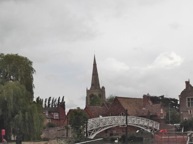 |
| The Chinese Bridge |

We walk as far as Portholme Meadow, reputed to be the largest meadow in England. It was formed from silt when the Great Ouse flooded, and according to the info board it still floods in the winter. It's covered with buttercups and a small pink flower at present.
We're now walking along the Ouse Valley Way, and follow the path.
 |
| Comfrey flowers by the path |
 |
| Hinchingbrooke Castle has sprouted a phone mast |
 |
| Pond and conservation area |
 |
Map and details
4 comments:
An interesting walk in an area I don't think I've ever walked in. People always say you live in Derbyshire so why walk here ... but I like to walk in different places.
I like your photographs too.
Thanks, Charlie.
When we moved here over thirty years ago, I found walking a real chore. Footpaths were blocked and overgrown, and there are no real hills. At least after Yorkshire and Derbyshire they felt like molehills.
Things have improved on the footpath front since then, and I appreciate the views from our lesser heights. The history of the area is fascinating too, and there are lots of lovely villages.
It looks like an interesting area ~ I just love walking as long as there's something of interest here and there. It's surprising how much interesting facts and history there is around.
I've really discovered a lot about the area since I retired, and got the chance to walk so often.
Post a Comment