and occasionally rides a bike.
A word of warning. The walk descriptions are not detailed enough to guide you - please take a map. The batteries never run out, and you always have a signal. Oh, And don't take left or right as gospel!

Showing posts with label Hanging Houghton. Show all posts

Saturday, January 7, 2017

Lamport, Scaldwell, Hanging Houghton, Lamport

We followed the route of this walk from August 2011. Map and details  are still accurate, and I used them as a quick reference. I walked with Maureen and Harry, and the walk is about 8 and a half miles.

Today was frosty, which improved conditions underfoot,  since some potentially soft and sticky mud was frozen.  Brilliant sunshine and blue skies with very little wind made this an enjoyable walk, with fine views of rolling Northamptonshire farmland, villages and trees.

We parked on the road not far from the church, and walked north east to a road junction, where we turned right. After a quarter of a mile or so we turned right along a path which took us through parkland and pasture behind Lamport Hall.

The path is crossed by another one in the middle of an arable field. Not clear on the ground, but we turned left and aimed for the gap in the hedge, where we found a waymarker. 

We followed the path along the hedge for a while, then had more arable fields to cross - here the path was fairly clear on the ground, heading towards the village of Scaldwell, which we could see at the top of the slope.
Heading towards Scaldwell
We walk past a few houses as we enter the village, then follow the road to the right, past the church. The road swings left, and just after The Grange we see a footpath sign pointing right.
Professorial owl

Is that the old road or the road to Old?

Festive birds

Scaldwell church

Is it coffee time?

The Grange
We followed the path through fields near some stable buildings, then a field with sheep and llamas (or alpacas?).

The footpath was pretty clear from here towards Hanging Houghton, which we reached after crossing the A508.

Sunny, not over warm, but time for coffee and a slice of cake or a scone.

We walked down Manor Road, which has almost no traffic. it crosses the Brampton Valley Way and a stream and turns into a farm track/ byway - easy walking for a while.
When we reached the T-junction we turned right towards Blueberry Lodge. Around here we saw lots of fieldfares, a couple of buzzards which had landed in the field, and a red kite, as well as the usual gulls.

At Blueberry Lodge we turned right again along a bridleway-cum-muddy footpath now heading back to Lamport.
Once againt the path was pretty clear through rolling farmland, eventually reaching the Brampton Valley Way once more. A convenient bench was too tempting, and we had the company of a bold robin - we fed it a few crumbs before tackling the final uphill stretch into Lamport.
From the footway alongside the A508 we had good views of the church and Lamport Hall through the bare trees.


This would make a fine setting for a story - the Old Rectory garden.

Monday, August 22, 2011

Lamport - Scaldwell - Hanging Houghton - Lamport

With Barry, Gordon and Maureen.  8. 7 miles.  Sunny! 


We left Lamport on the road towards Old, and shortly after this rather tall and beautifully situated house we took a footpath to the right. The house has decorative brickwork patterns, and displays the initials CEI (Charles Edmund Isham, the local landowner, gardener and reputedly the man who brought garden gnomes to Britain).
The path goes behind Lamport Hall - we caught just a glimpse through the trees from this side, and continues for a while, across a harvested field. In the middle of the field two paths cross and we took the one to the left - not very easy to see now the crop has been lifted.
The photo above is a great example of how not to compose a photograph - how many arms does Barry have?


We walked on and slightly uphill into Scaldwell, by way of a stile close to a row of houses.


It looks as though the tradition of garden figures is thriving in the locality.


Scaldwell contains several Grade 1 listed buildings, including some of those we walked past before we left the village.
Sundial House  has datestones (no not the fruit) from 1650 and 1772."The large sundialdated 1650 between first-floor windows, probably C20 restoration. Datestone 1650
and 1772 to left and right gables"
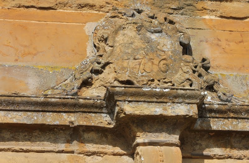
This is Scaldwell House, though I'm not sure whose initials R S are.


Is the date on the right 1706, 1716 or 1776? »


We walked past some very attractive cottages, and finally the Grange, before taking the marked footpath to the right. This led us across cultivated fields, including one which was full of flowering plants and (for once) some insects, gently downhill and then up into Hanging Houghton.  


Why this name? Because it hangs at the top of the hill?
Because it hangs on to Lamport? Anything to do with hanging? I haven't yet found out.


There we turned left following a minor road which goes steeply down to the Brampton Valley Way.  Just off the road and on the disused railway path there was a convenient bench, where we had a slice of Gordon's birthday cake. (Thank you Gordon and Maureen!) 


We didn't take the Brampton Valley Way but carried on along the unfenced road which took us very gently up to Blueberry Grange (no blueberries, just sloes).  We turned right, north-east to Blueberry Lodge. Just after that we took a bridleway (though it was more like a path) to the right, following a hedge.  There is a break in the hedge but it is possible to walk either side as there is another chance to cross after a quarter of a mile or so.  Next we had to walk gradually uphill along the edge of a huge field where the corn stubble was shining in the sun, then down to meet the Brampton Valley Way again.
We followed the bridleway up to Lamport.
pausing to admire the view from time to time
until we reached the A 508, and arrived back in Lamport


For details and map