and occasionally rides a bike.
A word of warning. The walk descriptions are not detailed enough to guide you - please take a map. The batteries never run out, and you always have a signal. Oh, And don't take left or right as gospel!

Showing posts with label Lleyn Peninsula. Show all posts

Friday, July 7, 2023

PEN LLŶN - JULY 2023 Yr Eifl

Tuesday 4th July

We left the house soon after 9, as we planned to walk Yr Eifl and weather was forecast to deteriorate later. In the event it has been fine all day.
An excellent walk - around 6 miles and 1500 feet of ascent and descent, some of it very steep, and some of it a bit of a scramble.
From Bwlch yr Eifl looking down on Nant Gwrtheyrn Welsh Language Centre

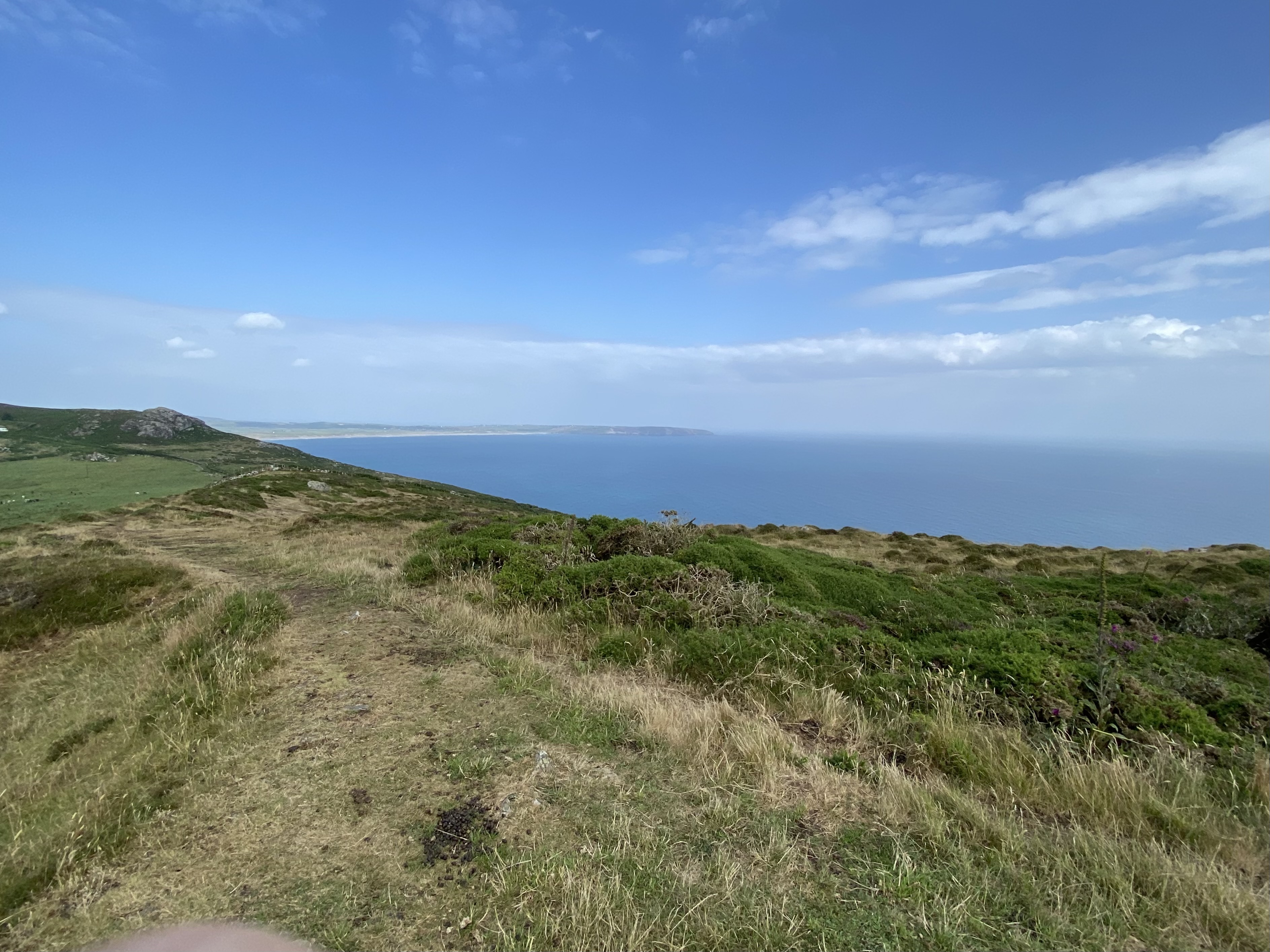
We began with Carn For, (Garn Fôr, Mynydd Gwaith),

which involved a clamber over boulders behind a radio mast enclosure,

but rewarded us with fantastic views over the peninsula


and Eryri/Snowdonia, though the higher peaks were attracting some cloud over there.


We found a slightly easier way down, and used the concrete staircase for part of it. Just below this we chatted to a couple about Llŷn and the Welsh language.  By now it was coffee time,  so we found a spot out of the wind to fortify ourselves with coffee and bara brith.
Onward with purpose


We could see the next section of our route, across the Bwlch yr Eifl path, and then up very steeply and directly to the top of the highest peak Garn Ganol, 564 meters high, or 1850 feet.  Mostly straightforward if steep, and again some boulder scrambling at the top.
We ‘capture’ Carn Canol

There were quite a few people up there.  Brilliant views again, and well worth the effort. The theory appears to be that the trig points A4H sculpture was put there by a local blacksmith to mark an unconsummated love affair. But, who knows? 
Looking back to Carn Fôr


From there we followed a decent path towards our next objective the iron age hill fort of Tre’r Ceiri (The settlement of the Giants).


Past the cows in the boggy section

Incredibly I’d never heard of this - supposedly one of the best preserved in Europe.


After a wander around we had lunch in one of the roofless ‘huts’.  On the way down we made a slight detour to an outcrop/ fort known as Caergribbin.


We headed across the hill and back to the car park .

Around 6 miles in all, and a really good walk.


We stopped at Ty Coffi in Nefyn,
A drop of goodness in every cup

and picked up a bit of shopping, (samosas, pakoras and veg) then back to base. 

Monday, July 3, 2023

PEN LLYN - JULY 2023 Carn Fadryn

 Monday 3rd July 2023

Afternoon walk from Garnfadryn village to Carn Fadryn hill fort. Views of Snowdonia as we drove to Garnfadryn, where we parked at a car park near the old chapel.
The peak of Carn Fadryn 


In case we were in any doubt - the way is up.

A short walk, under 2 miles, but involving around 620 feet of climbing to a height of 371 metres ( 1217 feet) It’s a very prominent hill with fabulous wide views in all directions. 
Looking back to Mynydd Rhiw ridge

Looking northeast.


We felt a few drops of rain at the top, and watched a huge shower pass over the hills just northeast of us.


How lucky was that! 


PEN LLYN - JULY 2023 - Evening stroll to Porth Ysgo

 Sunday 2nd July


After an inactive (recovery??) day, we had an evening stroll of two and a half miles down to the beach at Porth Ysgo to watch the sea reflecting light like a painting on silk,  and Italian painting style skies, and to listen to the waves breaking with  the occasional harsh grinding of pebbles in the undertow as the tide was turning.


 The wind had been fairly strong for most of the day, but now it had dropped almost to nothing. The waterfall is flowing, but is a mere trickle. I think this may well be standard unless there has been heavy rain. 


Sunday, July 2, 2023

PEN LLYN - JULY 2023 Ty’n Rhyd to Mynydd Rhiw, Treheli and Coastal Path


Saturday 1st July 2023

Similar route to this walk in 2021 and this one in 2022

We walked from Ty’n Rhyd, starting at 11.45 and walking east to Groeslon. A left turn, and we followed the small road, bordered with honeysuckle, meadowsweet and other wild flowers (red campion and sheep’s bit in particular).

Sheep’s bit or policeman’s buttons

Meadowsweet

The road bends right, passes Bodwyddog Fawr farm, and continues to a T junction. At this point the footpath leads straight ahead, quite clear until we reach a wide gate, then it was overgrown. We headed for the wall to our right , and more or less followed it to the radar station at Clip y Gylfinhir (Curlew Mountain).   A short steep scramble up the mound, because it is there, and the views are great.
View over Y Rhiw and the fort

Then down and along the track to the summit of Mynydd Rhiw, with its trig point  at 304 metres - not quite 1000 feet! A pause for photos and reflection, and to feel the wind.
Radio relay station on Mynydd Rhiw


We followed a footpath down to a cleared area (unofficial car park?)  and turned right along the road.  A ritual visit to the rocky outcrop on the left had to be made. 


We left the road at the footpath at Pen-y-mynydd, through the heathland nature reserve. 

Hunger was kicking in at this stage, so we found a spot to sit and eat.
We headed fairly steeply downhill, following the path through lushly growing  bracken, then there were a few boggy patches under trees. A side-track leads to Ffynnon Saint.

Self-heal, woundwort


We could have followed the footpath further, but instead took the wider track down to Ty’n Parc, then on to the old road past the camping and caravan site at Treheli Farm. To our delight the campsite has a cafe now, so we indulged in a coffee and then an ice-cream, and chatted about the Welsh language.
Refreshed, we walked along the road as far as the car park for Plas yn Rhiw, and a little further along the new road turned left along the coastal path towards Ysgo.   It leads through a couple of fields, then into a wooded area,

where it begins to climb, and continues relentlessly beyond the trees - gaining about 500 feet in less than a mile.


Views along the coast are spectacular, even today when visibility was not at its absolute best. 

We decided to include Mynydd Penarfynydd with its trig point at 177 metres, and followed the huge zig zag of the coastal path past the farm
Penarfynydd, complete with goat and dog

and on to the road near Porth Ysgo. We took the road towards Groeslon, then turned left towards Ty’n Rhyd.


Somewhere around 9 miles, and over 1000 feet of ups and downs. A fairly strenuous but highly satisfying walk.