and occasionally rides a bike.
A word of warning. The walk descriptions are not detailed enough to guide you - please take a map. The batteries never run out, and you always have a signal. Oh, And don't take left or right as gospel!

Showing posts with label Smeeton Westerby. Show all posts

Wednesday, August 11, 2021

Gumley, Saddington, Smeeton Westerby, Foxton Locks

 Thursday 05 August, with Eddie. 7.5 miles, 450 feet of up and downery.


Met Eddie at 9.30 at Gumley. We walked uphill through the village, past their free library phone booth with its window box,

then past St. Helens church,

keeping Gumley Wood on our right, to cross a minor road. Through this unusual stile

and on through the fields following the Leicestershire Round to the high point with a memorial seat with a fine view.


It was downhill briefly, past Saddington Reservoir,

and up the steepish slope to Saddington village. We continued on the LR past Loafabout Cottage, with its inviting seat. 
Then our route took us through a flowery ginnel, jitty or snicket.


We left the LR at this point, turning right by a farm with lots of old vehicles, claiming to do property repairs… The footpath took us through a field where the two sheep seemed like hand-reared pets.

Their reaction to humans was “Let’s see if they have something for us.”  
For a few hundred yards we walked on the Smeeton Road, crossing the canal bridge, then taking a footpath to our left, climbing gradually to a track marked as Mill Lane and into Smeeton Westerby (once two separate villages). 
We turned right down Debdale Lane, a surfaced track, which leads past Bridge 67 Farm and also promises a cafe (Carma’s Cafe - a pop-up mobile one, not open until Saturday) This track goes to the Grand Union Canal, slightly north of Debdale Wharf. 


We turned right and followed the towpath to Foxton Locks - coffee or beer and a cake.  
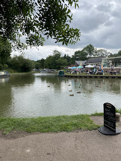
Then we just had to walk to our right over the bridge above the bottom lock and follow the footpath to Foxton Road, where we turned right and did a final climb back to Gumley. 

Monday, November 21, 2011

Laughton - Gumley - S. Westerby -Saddington - Mowsley - Laughton

Barry led. With Gordon, Maureen, Eddie.  9.4 miles.  Misty, not too cold. 49 stiles.


A pause while we regroup, just after Debdale Grange . . .


The Grand Union Canal


you can just make out Saddington Reservoir from the churchyard.


Eddie breaks the 'world record' as he climbs the 30th stile of the walk.


Applause as a new record is set - it now stands at 49! 


We can climb stiles as well.


the sun almost came out.


There are not many recognisable views here. The mist lifted a bit as we left Laughton. 


Map and details 

Thursday, July 28, 2011

Saddington - Smeeton - Debdale round

With Maureen, Barry and Gordon. 8.5 miles approx.  Three and a half hours including pauses. Weather sunny and warm. 


We started from Saddington, and walked along the Smeeton Road to Bridge 72. I intended to take a footpath for part of the way, but we didn't notice it as we passed it.  Then along the canal and over Saddington Tunnel, 
North western end of Saddington Tunnel


descending to the tow path on the left of the canal.  We left the tow path at Fleckney Bridge, where we used the two hand gates and crossed the bridge, taking the path through Mill Field Wood at right angles to the canal here. 


By the Mill Field Wood millenium stone


Past the MM stone and across the fields to the Kibworth-Saddington Road, and over into the mud and gravel track which becomes Mill Lane just before entering Smeeton Westerby. 
We turned right into the village centre, then left at Debdale Lane.  We followed this past Bridge Farm and Bridge 67 cookery school. 
This ad was on an old container-cum-shed near the cookery school. I googled and it seems it has now gone out of production to the chagrin of many cooks.


 Through a farm gate and we followed the track uphill until we reached the canal. Just before the gate and stile we found an inviting patch of shade for a snack and water break.


At the canal we turned left toward Foxton, passing the large narrowboat yard at Debdale Wharf, under a couple of bridges. 


Fine display in a boat garden.


 We crossed the first footbridge over the canal.  We took the path along the right-hand edge of the field, and across another, past some farm buildings and uphill thorugh a field where they may or may not have been a bull - there was certainly a herd of creamy and white cows, along with a lone horse.


The path led uphill with Gumley Wood on our left, across rolling countryside - the hilliest and most scenic part of the walk was saved until the later stages.  We crossed the small road from Gumley to Debdale, a little way short of the junction. A brief walk through thistle and butterfly country cut off a corner, and we crossed the road from Gumley to Smeeton.


Thistle and butterfly country


The path is a track between two hedges, then turns right to follow the edges of fields, clearly marked and climbing gradually, until, just before Smeeton Gorse, the Leicestershire Round path from Gumley joins our path. A short steep climb over grass leads to the highest point, with good views and a strategically placed bench.  (To the right of this is HIll Farm, Smeeton Hill, according to the map.) We followed the Leicestershire Round path along the 'ridge' then downhill , crossing two footbridges and going through a number of stiles before climbing to Saddington where we emerged along an enclosed path into the village, directly opposite the well-hidden footpath sign I missed at the start of the walk.


Map and details


Wednesday, July 27, 2011

Smeeton Westerby and Fleckney (Saddington) Tunnel

Almost 4 miles.
Started from Bridge 72 on GU Canal.  


Along tow-path on right of canal, on top of tunnel, across Saddington - Kibworth Road,  down to the tow-path on the left as far as the next bridge,


 leave the canal through a hand gate, turn left and left again  across the bridge, walk up through Mill Field Wood, 


across two fields, across Saddington - Kibworth Road, along Mill Lane into Smeeton W.  Footpath between hedges, then through horses' field to the church.  Over the road and along the path through the allotments. 


 Across road and through the ginnel (large alsatian barking in garden). Followed the path past the houses and up to the canal. Along towpath to the bridge.


Weather fine, warm but dull. The sun made a feeble effort to shine, but not for long. Dry underfoot.

Map and details

Now to find an extra four miles or so for a group of us to do together!
I did this walk from Smeeton with Harry on July 17 2010.

Thursday, June 9, 2011

Gumley - Smeeton Westerby - Kibworth Beauchamp - Foxton - Gumley

Thursday 9 June 2011. Barry and Eddie. Just over 8 miles.  About 3 and a half hours. One of the more hilly walks in the area, and some good views.  Not much arable field walking.


The Tower House Gumley - it used to be the stable block for the Hall.

St Helen's Church, Gumley.


Up above Gumley. Saddington reservoir is somewhere in the valley.
Fine views and splendid colours - the poppies have been magnificent this month.

The intrepid explorers (explorers are always intrepid)
As we walked downhill we noticed a raised ridge, clearly artificial, carrying water. At first it could almost have been a moat, although it didn't surround the hill, but continued flowing very slowly. So we had to investigate, and follow its course uphill and to the right of our official path. Eventually we found the spot where it joined the Grand Union Canal. 


A little nearer to our route was the outlet for excess water, into a stream flowing through this culvert.
and where any excess water drains off.