and occasionally rides a bike.
A word of warning. The walk descriptions are not detailed enough to guide you - please take a map. The batteries never run out, and you always have a signal. Oh, And don't take left or right as gospel!

Monday, July 31, 2017

Barnack

A walk around a nature reserve,  full of flowers and insects life


Thursday, July 27, 2017

Badsaddle again

Thursday 27 July 2017

Ok, this is getting boring! But I had to know the correct route for future reference, and striking with a hot iron seemed the best way. Today it was much drier underfoot, and the distance was 7.05 miles in all. 

I won't describe in detail - I did that earlier, but Maureen and I tackled this one again.
A few photographs and a map.
Abandoned farm

Picnic spot

Onward . . .

Looking back

Pilots practising formation flying


Wednesday, July 26, 2017

Pytchley, Broughton and Badsaddle

Monday 24 July 2017. With Maureen, Norma and Eddie. About 8 miles, because of a missed turning! 
Walking gets trickier when the crops have been harvested, and some paths head straight over sticky ploughed fields. We were following the instructions from a walk I did 6 years ago, but a couple of moments of inattention led me slightly astray.Underfoot was quite wet - the top layer of soil stuck to our boots.  Our deviation also presented us with wet legs after we'd walked through some rather lush vegetation.

I went back the next day, and after another false trail, finally found the correct route. I'll walk it again to fix it in my head.

Revised instructions!

1Park opposite the Overstone Arms, walk up to the crossroads, turn left along  the High Street. take the right fork to Top End, walk to the end of the End, and turn left through a farmyard.

Turn right after a black barn, and take a bridleway past farm buildings and then between fields.  Follow the bridleway between hedges as it swings left.  As this ends you come to a field where you bear right to cut across the corner, through a gap in the hedge, then follow the right hand edge of the field, keeping trees to your right.

2The track goes down to Underwood's Hill  Spinney, then across a footbridge and up a slope to the right to join a bridleway. Turn left and follow the bridleway to a gate.  There is a gap in the hedge leading to a narrow overgrown path - follow this to the stile at the other end and turn right. (There are plenty of notices here telling you to keep to the footpath!)
Over another stile and along a narrow fenced-in path. Another stile, and the path continues between walls, through what looks like a private yard, and out through someone's garden, more or less.Broughton church is on our right

3.  Walk down the path to Church St, turn left and join High Street and then left on Northampton Road. Walk to the end of the houses - quite a way - as far as a garage, which is not visible until close up.  Opposite is a footpath sign through a gate.  Turn left and cross the field - you can see the paths cleared through the crops. Walk with the hedge to your left, But before the end there is a stile on the left. Go overthis and continue in the same direction, but with the hedge on your right.  You cross two footbridges - both over dry stream-beds this time.

4. Go through a gap in the hedge, and turn right, crossing the field diagonally to the left to a gate in the opposite corner. Cross the minor road and walk along the farm track, continuing past the farm (Pytchley Lodge) which you pass on the left.

5.  Continue for 400 yards, ignoring a wide track to the right,  until you reach a waymarker pointing right. Follow the path across the fields(Or along next field boundary if, as we found, the field is freshly ploughed). Eventually this rejoins the correct route and leads round to the left of abandoned Badsaddle Farm. Take the first green bridleway to the left, through the hedge and over the next field to join . . .

6. . . .  a farm track - grassy rather than metalled.   You cross a farm road, close to a pylon, and in the next field keep to the left, with trees on your left.

7. At the bottom of a slope, turn right for about 30 yards and cross a serious footbridge.  Continue in the original direction, keeping the trees on your left.  You walk along a bridleway between hedges ( a bit overgrown) until you reach a minor road (Orlingbury-Broughton). Cross the road.

8. Head slightly diagonally left to the opposite corner, where there is a small gap in the hedge. Avoid the wide gap slightly to the right. Carry on with the hedge on your right.  In the next field, move away from the right hand edge, following the path through a dip a solitary tree to a gate.  Or follow the field edge round. Carry on through field to a gap in the hedge, and across another field of flax.You reach a stile just past some farm buildings.

9.  Turn left through the small farmyard, and down a path between the house and a wall.  You emerge at the corner of Butcher's Lane. Follow this to High Street, passing the primary school with its raised veg beds and mini-pond.  Follow the High Street back to the Overstone Arms.


Between 5 and 6 it is possible to add some distance by heading up to the A43, and then taking the farm track.

Not many photos - the weather was rather dull.

Oh yes . . . in Broughton!

Broughton church just after the path close to a cottage window.

When I've done the whole walk properly, I'll post again.


Monday, July 17, 2017

Empingham, Normanton and Rutland Water


With Marion. Monday 17 July 2017, starting at 9.30 am. Hot and sunny, dry underfoot. 7.25 miles.

A walk I have done several times with different people. Good views of the water from Normanton Cottages. A little road walking on quiet roads, a few stiles towards the end.

We walked along Crocket Lane in Empingham, near the church, and followed the streets, eventually arriving at the footpath along Willoughby Drive. Then it's across a field, with cattle who took no notice of us, over the stream and right along the Hereward Way (Mill Lane).

After the first house we crossed the field diagonally to the next footbridge, and walk slightly uphill along the edges of two fields. They look well ready to be harvested.  After the second field we crossed the A606 and continued along the path opposite, still following field edges until we reached Ketton Road. Here we turned sharply right and walked along the quiet road to the next junction. 
Knapweed, I think.

Here we turned left along Empingham Road past Normanton Cottages, which look as though they could once have been almshouses, or estate houses. There are lovely views of Rutland Water and the dam from this road. 

We carried on until the road bent to the left. We took the footpath straight ahead, with an intermittent wall on our right.

At the road we turned right and headed west towards Normanton car park on Rutland Water. The cafe was open, so we stopped for a drink in the welcome shade.

Then we followed the path round to the dam and across, before turning sharp right along the path with woodland on the left of us. At the bottom of the slope we climbed a stile into a field and then another one into more woodland - once again, just the job on a hot day!
To the woods . . . and out the other side


Another footbridge over a stream - looking a bit muddy for dipping feet - and a couple more stiles along the path to Nook Lane, Empingham, and back to the village and the car.
Off to Wellies at the garden centre for lunch. A very enjoyable 7 miles.


Tuesday, July 11, 2017

East Haddon and Holdenby - clockwise

Monday 11 July 2017.  With Maureen and Norma. This is almost the same walk as last Thursday, but in reverse, and without the wander off track. 7.6 miles, in dry warm weather, with about 300 feet of climbing.

We took the footpath which leads north not far after the Red Lion pub, past the sewage farm and Rye Hill, then along the lane and across a field - the hay has been collected since we were last here, and the way is very clear. When we reach the hedge we turn left, and follow it. In the next field we go through a gap in the hedge and through a field of oats - not yet harvested, but surely ready!

We cross the footbridge and the corner of another field, then follow the hedge uphill to the road between Ravensthorpe and Teeton. Norma identifies our mystery fruit from Thursday as damsons. We turn right a walk for a few yards along the road, then take the bridleway to our right, just where the road bends to the left.  The bridleway goes downhill , with the hedge on the right, and we recross the stream via another footbridge.

Then it's across a field of ripening rapeseed ( quite hard work, but it's dry and the varieties are not as tall as they used to be), along another hedge, through some rapeseed, untill we reach the footpath above Holdenby North Lodge, home of some fine-looking horses. We turn left and follow the path alongside the farm, and the road to North Lodge cottages. The footpath turns right and heads across several fields, slightly uphill towards Holdenby. There are stiles and it's pretty well marked.
Approaching Holdenby

A posing sheep
 We cross the road and walk through Holdenby village - no teddy bears picnic this time. It's about time we had a break, so we head to the church once more, and its well-placed bench.
 We have another brief look inside the church - this screen was once in Holdenby Hall, and the cross was added later. 


 From here it's pretty straightforward. From the lane to the church we turn right and follow the Macmillan Way downhill, turning right and following the track to the junction, marked by a fingerpost to East Haddon, where we turn right again. We have come past the hill with trees on top, which lies on our right.  The path continues until the building marked on the map as Rowell Leyes is in sight, and then goes gently uphill and to the right of the building.

At the field edge just beyond this we turn right then left then left again (three sides of a small rectangle). Ignore the larger track leading past the building marked as The Conduit. There is a sign saying that the land is private, but it's half hidden in the hedge.
Then follow this path beside the fields and the village cricket ground, before turning right and reaching Main Street once more.
We headed over to Brixworth for a sandwich and coffee. 
Once again, lots of butterflies and damselflies, and also skylarks and a coupe of buzzards.

Friday, July 7, 2017

East Haddon and Holdenby

This was a recce walk, and there is part in the middle which didn't quite go to plan.
With Maureen, on a hot day. Around eight and a half miles in all. Butterflies and damselflies in evidence along the way.
Village pump

Men at work


We began the walk from Main St in East Haddon, and walked along the footpath to Mill Street, just opposite the Red Lion, heading south, then turning east alongside the cricket field, and then for half a mile or so following field boundaries.
Then the path turns right, south,  at the end of a field, and right again,west, making three sides of a rectangle, before heading south once more, then slightly to the west, uphill. A right angle turn to the left takes you south west and goes gently down to join a surfaced track with Macmillan Way signposts, to Althorp and Holdenby. We take the left turn to Holdenby.  


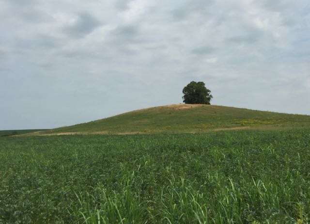
On our left is a small hill, topped with a tree.
We joined the Macmillan Way and turned left at a junction of paths, and climb quite steeply north east towards Holdenby. There are views of the church among the trees on the left. Almost at the top of the slope we turned left along the small road to the church, noting bear hunt posters along the way.


There are some interesting monuments in the church, including this memorial stone on the floor.


Even more interesting for us at this point was a bench with a lovely view.
We've walked just over three miles in some pretty serious heat.
When we decide to set off again we hear children chattering - it's a local primary school hunting for the treasure before having a teddy bears' picnic.

We call in at the old school house to see what's going on.
We walk along the road to the junction with the East Haddon-Chapel Brampton road, and cross over to the footpath, and meet the first stile of the day. Following the path north through several fields we emerge at North Lodge Cottages, and turn sharply left,or west, towards Holdenby North Lodge. The path runs to the south of the farm buildings and through a paddock with a couple of horses. The hedge is on our left as we climb up to a bridleway, where we turn right and follow the hedges north then north west.
At this point we missed a turning or two and managed to end up slightly off track, but we found the route we intended to take back to East Haddon from the Ravensthorpe-Teeton Road. As we stopped for an essential drink of water, we noticed these fruits across the road.
They appear to have one stone, but neither of us were sure what they were.  We headed back along the path which goes south as far as Rye Hill farm and cottages, uses the surfaced track for a hundred meters or so, then goes off the right. We pass the sewage works, on our left, resist the temptation to cross the footbridge over the stream, and walk towards the village. When we reach the corner of the field we turn left and the path is a few yards ahead, between the houses. It reaches East Haddon at Holdenby Road, slightly to the west of the Red Lion pub, where we had a very welcome cold drink.
I may well try this walk in reverse soon, so that I can recce the bit I messed up.