and occasionally rides a bike.
A word of warning. The walk descriptions are not detailed enough to guide you - please take a map. The batteries never run out, and you always have a signal. Oh, And don't take left or right as gospel!

Monday, January 29, 2018

Hambleton Peninsula, Rutland Water

Monday 29 January. With Marion, Kate and Eddie. Around 5 1/2 miles.
We're still sticking to the tracks and avoiding mud where possible. 

We parked at the end of the road, and walked the north side first - it's more strenuous, and good to have under your belt.
Just as we arrived at the point where track meets road the threatened rain arrived. It wasn't too heavy, and I tried to conjure it away by putting my waterproof on.

It  mixed with enough sun to produce a rainbow and then stopped.

The wind was quite strong, as we made our way along to the path round the southern side.
Another short shower arrived just after I'd decided it was time for a coffee break. Luckily it didn't last long and we arrived back at the car in time for another downpour. Lunch at The Orchard in Uppingham.

Saturday, January 27, 2018

Exton to Greetham via Fort Henry

Friday 26 January 2018, with Marta. A dry grey day, which turned sunny around midday. 7 miles. The same route as I took shortly before Christmas. Muddy near Fort Henry, and also near the chicken farm.

Coffee at Greetham Golf Club, lunch at the Plough Inn in Greetham.

We saw a buzzard perched on a telegraph pole on the way, and during the walk lots of bluetits and goldfinches at the feeders, and later a kestrel and a red kite.


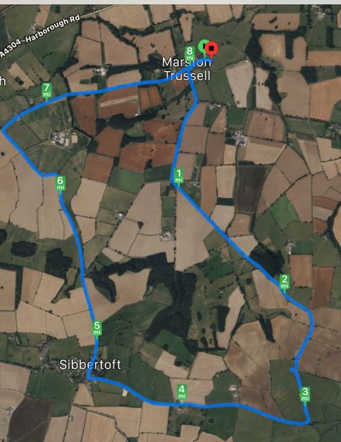
Marston Trussell and Sibbertoft, just missing Clipston

Thursday 25 January, at 10am. With Maureen. 8 Miles.  

Another brilliantly sunny, blue-skied day, with a noticeable wind. Warm enough when we were moving.  We chose to walk along the quiet roads in this area rather than take to the footpaths over mud-sodden fields. The walk was very similar to one we did on March 6th 2014, but in reverse and missing out the mile-long detour into Clipston village.

We turn left from the church and walk through Marston Trussell village, turning right with the main road, toward Clipston. It takes us past the lake, and at the junction toward Sibbertoft we turn right, following the road gradually uphill.


At the top is the ROC viewpoint: 
The info below comes from The Naseby Battlefield Project's website:
From the Royal Observer Corps lookout the full sweep of the day’s battle can be appreciated. To the north-east Rupert’s Viewpoint can be seen near East Farndon. Turning clockwise, the communications mast next to the A14 stands on the skyline and further right Fairfax’s Viewpoint. The spire of Naseby Church projects from behind a clump of trees and then the white bulk Mill Hill Farm appears. Woods obscure a view of Broadmoor, but then Lowe Farm, opposite the Reservoir parking, shows and to the right of that a lone tree stands on Moot Hill with the woods to the right of the open field. 

The stand on that hill continued until their comrades had established themselves on the nearer hill, Wadborough. Then the defenders of Moot Hill turned and ran for their lives, down the slope into the valley and up to their new position to continue the fight. How long they held out on Wadborough is impossible to say, but eventually they could stand no more and they fled down the slope to the right, still turning and resisting from time to time. The lucky ones, mostly horse, made it to Leicester.


After our short detour to visit the viewpoint, we were confronted by a different sort of army, just before Sibbertoft.
In Sibbertoft I saw my first snowdrops in full bllom for this year.
The bench in the churchyard was in a sheltered and sunny spot. As we had our snack, a friendly woman told us that they are trying to encourage flowers to grow around the village, and to avoid mowing too frequently. All good for the insects, bees and birds.
St Helen's, Sibbertoft
The source of the Welland claims to be in the Hothorpe Hills, close to the 540-foot (160 m) contour  near Welland Rise, Sibbertoft.
We took the road past the church , decided against the muddy field paths and followed it downhill, taking the left hand fork towards Marston Trussell and Theddingworth.


We didn't see any of these!
Almost opposite Hothorpe Hall, we turned right and arrived back at Marston Trussell.
Marston Trussell church (St Nicholas)


More snowdrops


Monday, January 22, 2018

Pitsford Water - a good standby

We've had a lot of grey days, snow, rain, frost too, but mainly just greyness. That and sheer idleness have kept me inside, watching catch up TV, reading books and the like.
But today was Monday, I had two willing companions and the sun was shining. The fields are still soggy and there are big puddles on some of the minor roads, but Pitsford Water posed no problems. The usual seven mile walk round clockwise from the cafe, and then lunch to finish.
After a mid-walk scone 

The usual birdlife - coots, geese, swans and seagulls on the look out for scraps. The catkins are very much in evidence now.

Saturday, January 13, 2018

Wing to Rutland Water and Lyndon circular

Monday 08 January 2018.  With Maureen, Norma and Eddie. Almost 7 miles on a frosty grey morning.  The same route as in March 2014 when the weather was much brighter!

We set off from Glaston Road, by the maze in Wing, crossed Morcott Road and took the first on the left, which is a bridle way. This took us downhill and north over the railway line and the river Chater, then uphill to the main road. We crossed this and took the small road past the campsite towards the Manton Visitor Centre.  
View of Rutland Water as we breast the hill.
 From there we turned right along the waterside track, and continued as far as the Sailing Club. Here we took the road past the school, up towards Manton Road, turning right along the path near the houses. We took a brief break in the bus shelter before following the road as far as the left turn towards Lyndon. We walked down this minor road to the village, turning right, then left and taking a footpath to the right which leads past Lyndon Hall. The church is just visible behind this, to our right.  The path takes a zig zag route along field edges, then joins the bridleway near the Chater. It just remained to walk uphill to the railway line and back into the village of Wing.

Tuesday, January 9, 2018

Catch-up again!

Over the Christmas and New Year period we were out a few times. No 'serious' walks, but pleasant interludes.

Harold Hillier Gardens near Romsey with Esther and family.


Following the trail


Sweet scented witch hazel

A walk in the New Forest on a frosty morning.


Corby Cube at sunset


Burrough Hill on New Year's Day.


Rutland Water looking moody.


Sunny Hunny, where we saw turnstones and oyster-catchers.