Barry led. With Gordon, Maureen, Eddie. 9.4 miles. Misty, not too cold. 49 stiles.
A pause while we regroup, just after Debdale Grange . . .
The Grand Union Canal
you can just make out Saddington Reservoir from the churchyard.
Eddie breaks the 'world record' as he climbs the 30th stile of the walk.
Applause as a new record is set - it now stands at 49!
We can climb stiles as well.
the sun almost came out.
There are not many recognisable views here. The mist lifted a bit as we left Laughton.
Map and details
and occasionally rides a bike.
A word of warning. The walk descriptions are not detailed enough to guide you - please take a map. The batteries never run out, and you always have a signal. Oh, And don't take left or right as gospel!
Monday, November 21, 2011
Sunday, November 20, 2011
Harringworth Lodge on a misty afternoon.
About 3 miles.
Ducks (mallards) and a heron by the lake and a few smaller water-birds, plus the inevitable rattling pheasant.
Friday, November 18, 2011
Clipsham short walk
'to the woods, to the woods', did I hear you cry?
Just under 4 miles there and back, behind a prison I'd not realised was there. Weather fine, though the ground is muddy in places, and the light was beginning to fade. Garmin functioned perfectly.
I stopped at Pickworth for a look at the footpaths.
The limekiln, which is so clear on the map, is behind a gate firmly marked 'Private, No Entry' and almost impossible to see from the road.
I drove to Clipsham, and parked on a minor road, just off the main road. I walked along this road which runs parallel to the main road, then turned right, past signs to the Hall, which is very well hidden. The church is more obvious.
. There is little danger of taking a wrong turning here - plenty of signs to indicate private property, and to be fair, decent footpath signs too. The path forms part of the Rutland Round.
You come out into a field where the route was well trodden, then through a gap in a hedge, and across another field - here it wasn't so clear, and as the cultivated field was quite muddy, I took a detour round the edge on the way back. There is a waymarker just before the wooded area at the bottom of the field. At this point you go through the hedge and follow the path along the edge of Addah wood, before turning right. I wondered what the high wall ahead was - it's on the map - the prison. The path through the woods is pretty easy to follow - when the yellow posts aren't obvious there are some white paint splashes, and a couple of arrows. I disturbed a couple of deer. Through Lady Wood and a left hand turn. Walk north until you come out of the wood. Follow the edge of the wood and go a little bit further to the quarry. I checked the time and decided to make my way back before the light faded.
Map and details
Just under 4 miles there and back, behind a prison I'd not realised was there. Weather fine, though the ground is muddy in places, and the light was beginning to fade. Garmin functioned perfectly.
I stopped at Pickworth for a look at the footpaths.
The limekiln, which is so clear on the map, is behind a gate firmly marked 'Private, No Entry' and almost impossible to see from the road.
I drove to Clipsham, and parked on a minor road, just off the main road. I walked along this road which runs parallel to the main road, then turned right, past signs to the Hall, which is very well hidden. The church is more obvious.
. There is little danger of taking a wrong turning here - plenty of signs to indicate private property, and to be fair, decent footpath signs too. The path forms part of the Rutland Round.
You come out into a field where the route was well trodden, then through a gap in a hedge, and across another field - here it wasn't so clear, and as the cultivated field was quite muddy, I took a detour round the edge on the way back. There is a waymarker just before the wooded area at the bottom of the field. At this point you go through the hedge and follow the path along the edge of Addah wood, before turning right. I wondered what the high wall ahead was - it's on the map - the prison. The path through the woods is pretty easy to follow - when the yellow posts aren't obvious there are some white paint splashes, and a couple of arrows. I disturbed a couple of deer. Through Lady Wood and a left hand turn. Walk north until you come out of the wood. Follow the edge of the wood and go a little bit further to the quarry. I checked the time and decided to make my way back before the light faded.
Map and details
Thursday, November 17, 2011
Wollaston - Strixton - (Grendon)Lower End - Gt Doddington - Wollaston
About 8.5 miles. With Barry and Gordon . Weather misty, but some sun, and a few drops of rain. Fields muddy, but not too muddy.
Garmin ran out of juice, so link shows general area and start of walk. By zooming out, you may be able to work it out! (WHEN I've described it a bit, that is!)
In need of David Hockney's step-ladder to snap the blue plaque! This is on the house next to the start of the footpath in Wollaston. The path leads between fences, past fields of llamas (alpacas?) and a pony or two, before arriving at open fields. Before long the path reaches the A509, which we crossed, then walked along a short distance to the right, to take the footpath, rather than the one marked opposite the crossing.
This tree is dead apart from the ivy. It is a marker of the direction of the path after we crossed the A509, heading towards Strixton.
![]() |
| Too cute to be real? |
![]() |
| Too real to be cute? |
At Strixton we turned left and walked along the road, for a few hundred yards. Then we turned off to the left, making our way south-east, slightly uphill then down into Lower End.
We turned right and walked along Blackmile Lane to Main Road. On the other side of this we turned north-east, then north-west, making towards a double row of electricity pylons. The path continued in the same direction, leaving the pylons behind until we reached a small road, crossing a field with a few horses, some of which thought we might be a good bet for a snack when we paused to shelter under a tree from the few drops of rain.
We followed a path near one of the old gravel pits, crossing the Nene just before the sewage works.
The path to Great Doddington isn't clearly marked, and we came up to the left of a farm building instead of to the right.
Turn right along the main village street, ignore the first Nene Way signpost, and carry on until you are almost out of the village. The path leads down hill, through a gap in the hedge and down to Doddington Mill.
We crossed the Nene again - lots of fish in the part near the mill. Then we followed the route we took last week, in reverse as far as the Road between Wollaston and Doddington. Instead of turning left along this road, we turned right and then left on to the road to Grendon. After a few hundred yards we took a footpath to the left, across a couple of fields, and the A509, and another short section of footpath before reaching the road leading up into the village.
A short detour to see the llamas, which were now outside, then we returned to the car.
We turned right and walked along Blackmile Lane to Main Road. On the other side of this we turned north-east, then north-west, making towards a double row of electricity pylons. The path continued in the same direction, leaving the pylons behind until we reached a small road, crossing a field with a few horses, some of which thought we might be a good bet for a snack when we paused to shelter under a tree from the few drops of rain.
Turn right along the main village street, ignore the first Nene Way signpost, and carry on until you are almost out of the village. The path leads down hill, through a gap in the hedge and down to Doddington Mill.
![]() |
| Pigs on the roof? |
A short detour to see the llamas, which were now outside, then we returned to the car.
Tuesday, November 15, 2011
Cycle ride via Fineshade
With Harry. Coldish wind but sunny! Drink at Fineshade.
Almost exactly same route as this ride on Nov 6th, but we didn't ride into Kings Cliffe to the shop.
Monday, November 14, 2011
Cranford - Burton Latimer - Cranford
Barry led this. With Maureen, Gordon, Eddie and Ian and Carol. Just over 7 miles. Fine, but grey. Muddy fields. Lunch at the old café in Cranford.
We set off from the street named Top Dysons, which is opposite Cranford Village Hall, heading west, across a couple of fields, then turning left before the Grange, passing Hayfield Lodge and to the Cranford Road. We crossed this and took a footpath close to some houses. The path had a couple of sections where we were almost obliged to crawl, as vegetation was taking over. The path takes you to the A14, but by walking on the path almost alongside, and up to the roundabout we had simply to cross a couple of not-too-busy slip roads. We then walked back until we were opposite the original course of the path. Next obstacle was the A6 - patience required, but no problem. At this point we walked south towards the edge of Burton Latimer. We follwed the edge of a couple of fields, and turned briefly left then right, eventually joining Church St, which we followed to woodcock st and then into fields. (I think this is where new houses are being built.) The path took us east, down to the A6, which we had to cross again
We were now close to the wind turbines, and walked through the fields, pausing for a snack break at a footbridge. The path continued eastwards, coming out at the A510, at the Round House.
We set off from the street named Top Dysons, which is opposite Cranford Village Hall, heading west, across a couple of fields, then turning left before the Grange, passing Hayfield Lodge and to the Cranford Road. We crossed this and took a footpath close to some houses. The path had a couple of sections where we were almost obliged to crawl, as vegetation was taking over. The path takes you to the A14, but by walking on the path almost alongside, and up to the roundabout we had simply to cross a couple of not-too-busy slip roads. We then walked back until we were opposite the original course of the path. Next obstacle was the A6 - patience required, but no problem. At this point we walked south towards the edge of Burton Latimer. We follwed the edge of a couple of fields, and turned briefly left then right, eventually joining Church St, which we followed to woodcock st and then into fields. (I think this is where new houses are being built.) The path took us east, down to the A6, which we had to cross again
We were now close to the wind turbines, and walked through the fields, pausing for a snack break at a footbridge. The path continued eastwards, coming out at the A510, at the Round House.
The Round House, Burton Latimer - Thrapston Rd A510, OS grid 9374
Here we turned north, then north-east, and east to skirt an old quarry/ dump before reaching the A14. Once over the road the path took us to the Cranford Road, into Cranford St John, past a disused railway, and the primary school, past the pub (closed on Mondays), and along a path which leads downhill, through fields (Hall grounds) to the church and dovecote, then to Cranford St Andrew, and the Old Forge Café.
shortly before the A14 crossing
St Andrews Church
the dovecote
Map and details
Thursday, November 10, 2011
Irchester-Wollaston-Doddington crossing-Irchester
9 miles approx. Barry, Gordon, Maureen. Misty, fine weather.
We started from Irchester (Woodlands Road) and took a footpath between two houses, which led us over fields, across the B569 and to Wollaston. We emerged into Wollaston near the Scott Bader factory, and some houses, including one with several chickens in the garden.

We walked through Wollaston, past the church which was slightly to the right of our route, and spotted an attractive walled park, once part of the manor house. The seats were tempting, but it was far too early for a break, so we carried on and crossed the A509. We followed the road towards Great Doddington, turning right after a third of a mile or so. Our path turned slightly to the left (north-west), and we took a path between two lakes, and along a track towards Doddington Crossing and the Mill where several narrowboats were moored.
At this point we joined the Nene Way, and followed it along the river into Wellingborough. This was part of my route on August 5th, on a fine hot day!
Behind Chester House, which is being restored, repaired or rebuilt, is the remains of a walled kitchen garden with conservatory and fruit trees - just out of our reach!
We had to cross the A45. It has a central reservation and path, so is possible with care. Then we took Chester Road, past Townend Farm into Irchester, passing Lower Farm, and a cottage called Cwmnene. We made a small detour to look at the info board in St Katharine's Walk, and to seek out the (very small) Catherine Wheel which is part of the weathervane. Ha ha - wrong lens again ;-)
October 2012: Update about Chester Farm site - they may open a heritage centre for the Roman site.
Map and details
We started from Irchester (Woodlands Road) and took a footpath between two houses, which led us over fields, across the B569 and to Wollaston. We emerged into Wollaston near the Scott Bader factory, and some houses, including one with several chickens in the garden.

We walked through Wollaston, past the church which was slightly to the right of our route, and spotted an attractive walled park, once part of the manor house. The seats were tempting, but it was far too early for a break, so we carried on and crossed the A509. We followed the road towards Great Doddington, turning right after a third of a mile or so. Our path turned slightly to the left (north-west), and we took a path between two lakes, and along a track towards Doddington Crossing and the Mill where several narrowboats were moored.
At this point we joined the Nene Way, and followed it along the river into Wellingborough. This was part of my route on August 5th, on a fine hot day!
Wellingborough Embankment - just right for a stop. Thank you for the scones, Maureen!
After a break we carried on along the riverside.(I did a bit of this accidentally on August 16th) Loads of swans, ducks and gulls hang out there. There were a lot of horses grazing. Most of them had manes and tails covered in burrs, like this poor fellow.
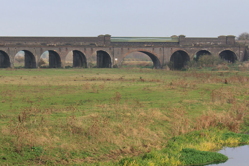
When the mainline viaduct came into view we started to make our way towards Chester house.
At this point we joined the Nene Way again (see my walk on Tuesday 16 August).
We walked around to the right of the house to investigate the site of a walled Roman town. We saw part of it, but there may have been more. Behind Chester House, which is being restored, repaired or rebuilt, is the remains of a walled kitchen garden with conservatory and fruit trees - just out of our reach!
We had to cross the A45. It has a central reservation and path, so is possible with care. Then we took Chester Road, past Townend Farm into Irchester, passing Lower Farm, and a cottage called Cwmnene. We made a small detour to look at the info board in St Katharine's Walk, and to seek out the (very small) Catherine Wheel which is part of the weathervane. Ha ha - wrong lens again ;-)
I like the banded stone effect. The spire is the tallest in the county.
A short walk took us back to the start of the walk.
I was pleased to have walked along part of the Nene I hadn't covered before.
October 2012: Update about Chester Farm site - they may open a heritage centre for the Roman site.
Map and details
Subscribe to:
Posts (Atom)