and occasionally rides a bike.
A word of warning. The walk descriptions are not detailed enough to guide you - please take a map. The batteries never run out, and you always have a signal. Oh, And don't take left or right as gospel!

Showing posts with label Cranford. Show all posts

Wednesday, July 17, 2024

12th March 2024 - Cranford

 12th March 2024

Marta and I decided a coffee in Crawford would be a good start to the day since the weather was wet.  The Old Forge was pretty full and we found ourselves wedged into a corner spot on high chairs facing a wall, using a wide shelf as a table.


As soon as we had finished we left, and as the rain was easing we booted up and took ourselves for a short walk.In the end we did close to four miles, passing St Andrews Church, which we found later on we could go inside, and then St John’s, with its many grotesque faces on the windows and door way. Then we continued  via Duck End on a quiet road eventually leading through Cranford Wood.  We turned back at the junction with the road between Grafton and Slipton.  We stayed almost dry, and it wasn’t cold.

Tuesday, April 4, 2017

Cranford and Twywell Hills and Dales.

With Maureen. Thursday 16 March . 7.8 miles. Around 200 feet of ascent. 

We set off from Top Dysons, near the Old Forge in Cranford St Andrew, and walked along St Andrew's Lane, as far as the footpath to the right, which took us through the grounds where the church and hall are situated. There were plenty of sheep and lambs.

The path heads across the parkland and emerges at The Green, which becomes Church Lane and passes St John's church.
Shortly afterwards we take the footpath which leads through a field, up to a gap in a fence, and down a dip with a footbridge.  We should have stayed further to the right, as we ended up close to the off-road tracks in the old quarry. In the end it was not a big problem and we made our way to Twywell. We walked along High Street, the Green and Lower Street before following the footpath sign to Twywell Hills and Dales, on the site of old ironstone workings. 
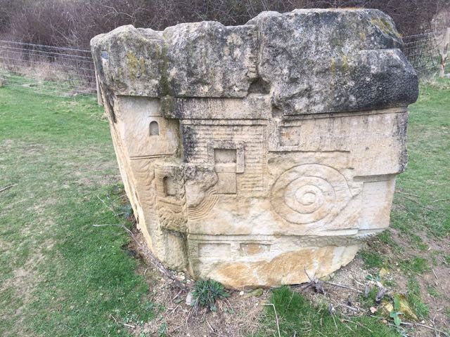
The first part of the path is through pleasant woodland, then there is a section where the noise of the A14 is intrusive. We followed a path between fences which brought us to this carved stone.
Notice the Dartmoor ponies which are there to graze and protect the habitat.

By following the map and path signs we made our way back to Cranford - almost seven miles in all, but I need to walk it again to get the route clear.

Thursday, March 9, 2017

Cranford, Grafton Underwood, Warkton

Thursday 09 March, 10.00 am. With Maureen.  Beautiful sunshine, though the wind still had an edge. Most of the mud in the fields was drying. Very little climbing, but slightly longer than I thought at 8.7 miles.

Near the Old Forge cafe we followed the road out of the village (not St Andrews Lane).  After about half a mile we crossed a line of pylons and a little further on, as the road bends there is a gap stile in the hedge on the right hand side. This is the footpath - the hedge was on our left, and we followed it as it turned left and headed more or less north.  There was a short wooded section, and after almost a mile we met the road.

A wooded section of the path from Cranford
 We turned left and followed the road round a bend to the left as far as the crossroads. A right turn took us into Grafton Underwood, with its stream and bridges, and its attractive church.
The church at Grafton Underwood

Spring is springing
 Just before the village boundary is a footpath sign. We followed the path to the left, through a field with a horse and pony - I blame them for the state of the ground near the gates.
A friendly pony
 The next field had more ponies, behind an electric fence this time. It left the path pleasanter to walk on!
 We had several stiles to negotiate, one or two needing some high-stepping on our part. The ploughed fields were drying in the sun and wind, and the paths had been made clear. We have seen much worse . . .
Mud is drying, and the path is clear
 It was a relief to arrive at a stile leading into a meadow. We crossed the estate road and walked along a field edge to the path which crosses the lime tree avenue.
The lime tree avenue near Warkton
 Next we walked along the footpath which emerges next to a house on the main road through Warkton. The little green opposite is putting on its spring clothes.
Chocolate box pretty


These look like some kind of cultivated celandine
We made our way to St Edmunds Church, which has a fine selection of monuments to the Montagues, but wasn't open. Thursdays after Easter, it says.  We took advantage of the sheltered porch, in the sunshine, to have a break. Five miles down, not so many ahead!

The next section of road walking requires caution, as this road is a bit of a rat run, though not too busy at this time. As you come out of the village there is a short hill and a bend, and the verges are narrow. Then there's a straighter section with wider verges. I saw a brimstone butterfly - the first I've seen this year.

We passed a road joining ours from the right. A little further ahead the road bends to the left, and our path turns off. It's a bridleway, more or less following the line of the road. It crosses the grassy ridged and furrowed field, and goes through a gate into a wide section marked as an avenue of trees on the map. It continues following field edges, heading slightly south of east, with a short dog leg over a stream, eventually joining a wider track, where we turn ot our right and head slightly west of south. We followed this until we were opposite the buildings of the Grange. We turned left (east) and the track takes us all the way back to Cranford.


Monday, October 5, 2015

Cranford and Grafton Underwood

Mon, 5 Oct 2015 9:36 BST
Carol, Tommy, Terry, Maureen and Gordon and me. A drizzly grey day, but we didn't get soaked. The recently ploughed fields were rather hard going. Lunch at Old Forge. A bit under 7 miles.

A grey day, and not much temptation to take photos.  We covered parts of the previous routes around here.

From the Old Forge Tearoom we walked along Top Dysons, and through the fields following the bridleway until just before the Grange. Here we turned right, roughly northeast, and continued for about a mile in this direction. At a point where there is a concrete post we turned left, heading slightly north of west, crossing a section of lime tree avenue again, until we met the road on a bend.

We turned right and walked for a few hundred yards beside the road, turning left at the next bend along a farm track. A few yards along, just after a hedge we went through a gate to a footpath on the right. this goes diagonally to a gap in the hedge, then we had to cross two ploughed fields. (Note for future reference - aim more or less for the opposite corner of the second field to find the waymarked path.) These fields were still reasonably dry.

Here we went through a gap in the hedge and then by the left hand side of a small wooded area and another couple of ploughed fields. These were getting sticky in the drizzle, so we were pleased to walk along the side of the next field, again by some trees. No alternative in the next field though, but this was a short stretch.

We managed to avoid ploughed fields by following the edges, and on one occasion taking a half-blocked path through a hedge.  The photos make it look worse than it was. Really!

The alternative was to retrace our steps, and I am loth to do that! 
We made our way past some slightly skittish horses and took a break in Grafton Underwood, once more attended by ducks and the little cat from six weeks ago
Rather than face yet more mud we walked back to Cranford along the roads - which are fairly quiet. 
The Old Forge does a good soup and substantial sandwiches which were very welcome. A short walk, but enough considering weather and conditions in some of the fields.

Wednesday, September 2, 2015

Warkton, Grafton Underwood and Cranford


Thu, 2015 Aug 27 9:35 AM BST
With Maureen. Long break at Grafton, then coffee stop at Cranford. Arrived at the car just as the rain started to come down heavily! Seven and a half miles or so.

From Warkton, opposite road junction between cottages, and across the lime tree avenue, as on this walk of August 18th.  The route is the same as far as Grafton Underwood, and it helped to have walked it before.

At Grafton Underwood we paused to check the next section of the route, but were greeted by a local resident who handed us choc- ices on sticks, and told us a lot about the village and the Duke of Buccleuch who owns all the property.

From Grafton we took the road to Cranford, and made use of the Old Forge for a coffee - three times in two weeks, I think.


From Cranford we walked out along Top Dysons, following the bridleway until just before the Grange. Here we turned right, roughly northeast, and continued for about a mile in this direction. At a point where there is a concrete post we turned left, heading slightly north of west, crossing a section of lime tree avenue again, until we met the road on a bend. A left turn and some traffic dodging on to the verge took us back into Warkton.
I'd just unlocked the car when the heavens opened.

Warkton and Cranford

Tuesday 25th August 2015

Tue, 2015 Aug 25 9:41 AM BST
With Marta. Fine and dry. Rain to come? About 6 miles in all.
Coming out of Cranford after Top Dysons

Warkton church - there's a lot of smoke around!

Looking over to Warkton village.
Map and details

Tuesday, August 18, 2015

Warkton, Grafton Underwood, Cranford St Andrew

Mon, 2015 Aug 17 9:22 AM BST
With Gordon. Weather fine and dry, some sun. Mostly good paths, a few ploughed fields, but dry. Just under 10 miles. Fairly flat.

I was looking for a walk nearby that would cover some new ground.  Warkton and Grafton Underwood fit the bill.  Why haven't we walked there? The walk is on the edge of the Explorer Map, and needs some folding and unfolding. So I packed the Landranger map as well.

We set off from a side street in Warkton, taking a path directly opposite the road, heading east between two houses, then over a stile and along a path between hedges. Another stile took us into a field with an avenue of lime trees. The sheep were having a lie-in, and moved reluctantly as we made our way through. 
It was tempting to follow the line of trees, but a map-check showed that we cross them to the left diagonally. We found our route waymarked, over a stile and alongside a field, then across a private estate road. Cows in the next field came to see us through the gate at the end.
The next section involved keeping the same direction across a couple of ploughed fields with no clear path yet, and then by the left hand side of a small wooded area and another couple of ploughed fields. It's that time of year, and luckily the ground was dry.
Some of the signage leaves a bit to be desired.
So we are on right path?

Oh yes!
We continued along paths which led into Grafton Underwood, through a field with horses, and one sheep which saw us and ran towards us - we thought it was a pet until it headbutted its way through the broken dog gate at the stile and went to join its fellows in a paddock close to the houses. 


Grafton Underwood is an attractive village, with the stream running beside the road, and, early as it was, the bench by the bridge was not to be resisted.
Ducks and a cat watched us without pestering.

It was agreeable walking through the village, next to the brook.


The next section involved a bit of road walking, south to the crossroads, then left as far as the first footpath sign on the right. The path runs more or less south along field edges, then swings right (west) to meet the road. A little tricky to be sure you're on the right track here, but we were close to the pathline.
We turned left for another section on the road into Grafton Underwood, where we were ambushed by the Old Forge café. 
Opposite the café is a road called Top Dysons. This is our route and leads to a bridleway, good and clear. We turned right to head north just before Grange Farm, but there are several footpaths and bridleways around here.  

We continued slightly east of north as far as the road between Grafton and Warkton. After a mile of dodging the cars - just a few too many to make it pleasant, we arrived at the estate road, and rejoined the path we started on, crossing the lime tree avenue once more.
Lime Tree Avenue with sheep
This was a much pleasanter way back into Warkton.

Garmin machine says 10.2 miles, but when I synched it with the computer programme the distance given is 9.7.


Wednesday, May 22, 2013

Twywell circular


Tue, 2013 May 21 10:34 AM Western European Time 
With Marta. Good weather, fairly flat. Some navigational tests because of poor waymarking, and paths not made clear on the ground. One accidental timer stop. One crossing of A14. About 10 miles ish. Grey weather but no rain.

From Twywell to the footbridge over the A 14 .  We head towards Woodford, and walk through, past the pub and turn right, ignoring the church and paths to the left. We walk for a little way along the road - not too busy, luckily.  The foot[path is clearly marked and we walk along a plain track. Too plain, as it happens, and we realise we have gone a couple of hundred yards too far, so turn back.

How did we miss the tumuli, labelled Three Hills? The usual lack of mapwork, I suppose!  Unfortunately we can't see the path on the ground, but work out where we should be able to meet it by walking along field edges and finally see the waymarkers. Back on track we head for Rectory Farm, and turn left into Great Addington, in search of lunch. We find this at the Hare and 'ounds. It's dropped its aitch, poor sign.  A good enough sandwich, a friendly landlady, and rather dear J2O, but it does the trick.

Off we go again, taking the path from Cranford, beside the Manor House.  We have a slight feeling of dread on seeing the sign "Footpath to Burton Latimer", but hope we'll be able to find the paths on the ground as clear as on the map. It's not to be, of course, and each time we stop and look for a trace of a cross-field "made good" path, we are disappointed.  To cut a long story short, we try our best, find some way markers which don't help a lot, and emerge on the A510 about half a mile to the south of the Round House.  For the sake of simplicity we walk along the road - there is a decent sized grass verge.


At the Round House we take the bridle way north, over the drive to Wold Farm, and a couple of fields, before we turn left along a hedge and then follow a diverted path round the edge of a quarry.  

Then over a field and we have to brave the A14 itself.   Life would be pleasanter with more bridges and subways!  The central reservations makes the crossing simply a matter of patience, and we are on the edge of Cranford.  We have to do a bit of thinking to be sure that we're on the right track towards Twywell  At first we wandered too far to the right.  


Once on course, it's pretty straightforward, and we arrive at the Hills and Dales country park - we walk north east into Twywell. 

We saw and heard a pair of lapwings and lots of red kites.

A footnote - Irthlingborough's Waterloo film centenary!

Map and details

Monday, September 3, 2012

Cranford St Andrews - Burton Latimer - Cranford St Andrews

Led by Barry. With Gordon, Eddie, Terry, Jill, Carol, Ian and me. Beautiful sunny warm day. A lot of fields and three busy roads to cross.  Same walk as this one last November, but in reverse.  7.3 miles. 

We set off from Top Dysons, crossed the road and went past the Old Forge tea-rooms along Grafton Road to the right.
Soon the footpath took us off the road to the left. We turned to our right when another path crossed ours, and followed this to the south eastern corner of the field, then south and east and south again before coming out on Church Lane and Cranford High Street.  We walked along this for a while, then followed the path right to the edge of the field and steps down to the A14.  Patience needed to cross this. Luckily there is a division in the middle of the very busy road.


Banana break! A shady, though not scenic spot.


More later. Map and details

Monday, November 14, 2011

Cranford - Burton Latimer - Cranford

Barry led this.  With Maureen, Gordon, Eddie and Ian and Carol. Just over 7 miles. Fine, but grey. Muddy fields. Lunch at the old café in Cranford.


We set off from the street named Top Dysons, which is opposite Cranford Village Hall, heading west, across a couple of fields, then turning left before the Grange, passing Hayfield Lodge and to the Cranford Road. We crossed this and took a footpath close to some houses. The path had a couple of sections where we were almost obliged to crawl, as vegetation was taking over.   The path takes you to the A14, but by walking on the path almost alongside, and up to the roundabout we had simply to cross a couple of not-too-busy slip roads.  We then walked back until we were opposite the original course of the path.  Next obstacle was the A6 - patience required, but no problem. At this point we walked south towards the edge of Burton Latimer. We follwed the edge of a couple of fields, and turned briefly left then right, eventually joining Church St, which we followed to woodcock st and then into fields. (I think this is where new houses are being built.)  The path took us east, down to the A6, which we had to cross again  
We were now close to the wind turbines, and walked through the fields, pausing for a snack break at a footbridge.  The path continued eastwards, coming out at the A510, at the Round House.


The Round House, Burton Latimer - Thrapston Rd A510, OS grid  9374


Here we turned north,  then north-east, and east to skirt an old quarry/ dump before reaching the A14.   Once over the road the path took us to the Cranford Road, into Cranford St John, past a disused railway, and the primary school, past the pub (closed on Mondays), and along a path which leads downhill, through fields (Hall grounds) to the church and dovecote, then to Cranford St Andrew, and the Old Forge Café.


shortly before the A14 crossing
St Andrews Church
the dovecote
Map and details