and occasionally rides a bike.
A word of warning. The walk descriptions are not detailed enough to guide you - please take a map. The batteries never run out, and you always have a signal. Oh, And don't take left or right as gospel!

Showing posts with label Tugby. Show all posts

Sunday, May 26, 2019

Back to base - Tugby - Loddington - (Skeffington)

With Marta, on Wednesday 22 May 2019. Seven and a half miles, starting from Café Ventoux on the strict understanding that we'd have lunch there, not just use them as free parking! 

"We take our name from the famous cycling Mountain, Mont Ventoux in France, which has been featured in the Tour de France since 1951."

The walk covers much of the same ground as this one.

We set off turning right away from the A47, and after a couple of hundred metres we turned right along a track signed as a bridleway, heading east towards East Norton. We followed this at Little Gunsel. At a junction of paths we continued ahead through more woodland (Hardy's Gunsel this time), with a hedge on our right.  At the next junction we took the right hand  path, heading southeast, crossing a small stream.

There's another meeting of paths and at this point we caught sight of East Norton Hall through the trees.
We turned very sharp left, slightly west of north, taking a freshly marked (weedkilled) path over a field and down to a footbridge, marked on the OS map as a ford. We kept the hedge on our left and walked uphill to the remains of Loddington Mill (just a base as far as I could tell), then along a cart trackwhich bent round to the east toward Loddington village. In the hedge on our left is a stile and a path to Loddington church - conveninet bench here for a break.


Carved heads old and newer.


We went back to investigate the disused railway line - there's a permissive path heading south, but no clear access to head north. We met a woman radio tracking nesting pheasants for the Game and Wildlife Conservation Trust which has a project nearby.

We decided to follow the path by the church to the village and the road which turns left, then left again at Oxey Farm along Wood Lane. About a mile further on, at the bottom of a hill,  we turned left on to a footpath by the Eye Brook. We crossed the stream - again the map marks a ford, but there is a bridge. 
We climbed gently along a wide track towards Skeffington Lodge Farm, and couldn't resist another pause for a drink.

Time for a selfie!

Typical scenery and sky
Past the farm and a couple of houses we turned left along the Midshires Way - the path is now clearly marked and easy to follow. We arrived close the the A47, and turned left at a right angle, and followed the path to Wood Lane, where we turned right and returned to the cafe - for lunch as we had promised. 

Saturday, May 4, 2019

East Norton, Loddington, Skeffington, Tugby and Café Ventoux.


Thursday 02 May, with Maureen. Somewhere around 8 miles. The app went mad between mile 6 and 7!  Rain was forecast for later and started to fall just as we reached the car.
We started from East Norton, taking the road towards Loddington until we found a bridleway sign. We turned left along the bridleway and walked for roughly the same distance west until we met a junction of paths. We walked round the edge of a field
rather than follow the strict path line, as it was rather muddy. We crossed the second field, which wasn't too bad.
Then we had to cross a footbridge and walk slightly uphill with trees on our left.  we soon joined a cart track, which curve round to the right. After a while we crossed a dismantled railway line. There is a permissive path here, but we ignored that and went through a gate to our left, just after it. The path leads up to Loddington Church, which is some way outside the village.

The path goes through the churchyard, turns right and joins the minor road after crossing another footbridge. At the road we turned left and left again at the junction. The road was pretty quiet - we saw maybe three cars and four bicycles.  
The weather looked a bit dramatic, but we stayed dry!
After a mile or so we turned left at a crossroads, and then walked for almost another mile on Wood Lane, an undulating road, turning along a footpath by the Eye Brook, at the bottom of a hill. By now we needed a break, and improvised seating.


We walked on parallel to the brook, a little higher up, then crossed it via a footbridge, 


before turning to our left and climbing gently towards Skeffington Lodge Farm with its buildings and impressive mini solar array. We continued past a few houses until we met the Midshires Way. We turned right and followed it south, across another slightly sticky field.  We should have aimed directly for the point of the triangular woodland, but misjudged it slightly - even Leicestershire's yellow marker posts are not always instantly visible! 


Looking back to Skeffington Lodge's solar panels and possibly Robin-a-tiptoe.
Back on track we walked up to the A47 before turning sharply left and following a clearly (with weedkiller?) marked path over a field and then along field edges to meet Wood Lane again.
At this point we turned right and walked for a few hundred yards along the road as far as the Café Ventoux. The countryside round here is a little gentler than the place it's been named after, but it is a welcoming place and does a decent coffee.

After this it was a matter of retracing our steps along the road, and picking up a footpath east, to our right, at the wooded area called Little Gunsel. At a junction of paths we continued ahead through more woodland (Hardy's Gunsel this time), with a hedge on our right. At the next junction we took the right hand path, heading southeast, crossing a small stream. Right again at the next junction heading south with East Norton Hall on our left. 
When we came to the village road, we turned left and made our way back to the car.

A short drive back to the Café Ventoux for lunch completed the walk.


Thursday, April 4, 2013

Goadby - fig of 8 via Noseley and Rolleston


Thu, 2013 Apr 4 9:32 AM Western European Time 
Led by me, with Maureen, Barry, Gordon and Eddie. Chilly - even some light snow at the start. One glimpse of the sun in the last half-mile. Underfoot mainly firm, but with muddy patches. Just about 9 miles in all.

We take the minor road towards Glooston and follow it as far as Glooston Lodge Farm with it sign warning of "free range children and animals".   we turn right next to a big barn where a farmer is transporting bales of hay to feed the cows which are still indoors this year.

The path is clear, for a while, then goes uphill across a field, where we aim for the pylons, and then the waymarker to our right.  At this point we find ourselves a little too far over to the left , and have to retrace our steps along the stream to find the footbridge. 

After this it's more or less a case of following the waymarkers,  through the edge of Noseley Wood,  and then through fields to a metalled track, and across a couple more fields to the road.   There's still snow around, and mud or water under a covering of ice at many of the gates.


 When we reach the road we turn right and pass the fine gates and drive to Noseley Hall - there's a sign to the cookery school which is run there.


 We follow the road past the right turn to Goadby, and turn left along a footpath between hedges leading uphill.  The wind's pretty fierce, but we cross another field into some more woodland and find a sheltered spot for a break.  Our path continues until we meet a clear track which takes us past Rolleston Lake.

We carry on for another quarter of a mile or so to Rolleston Hall and church.


Back along the same route, past Goldsmith's cottage, until we meet the footpath to Tugby.  This goes alongside Pop's spinney, through a field where the farmer has just brought some sheep and lambs.  We follow the yellow posts towards Tugby, but turn right before we reach the village.  Our way lies past Lake House Farm, and out to the road from Tugby.  We take the road directly opposite the footpath, which leads us along a gentle flat half mile or so back to Goadby.
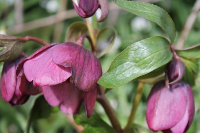
Hellebore flowering by the roadside in Goadby