and occasionally rides a bike.
A word of warning. The walk descriptions are not detailed enough to guide you - please take a map. The batteries never run out, and you always have a signal. Oh, And don't take left or right as gospel!

Showing posts with label OS Explorer 235. Show all posts

Monday, August 19, 2019

Southey Wood, Ufford, Castor Hanglands, Upton

Monday 12 August 

8 and 3/4 miles, with Eddie and Norma. Flat, although with a high point! Fine weather.

We parked near Southey Wood, where the car park is now closed.


 We followed the main footpath north and then west, eventually turning right, north along the bridleway known as "the drift". At Marholm Road we turned left ,  swinging right through Ufford.  
St Andrew's church was the "highest point", on Church Hill, at 44.16 meters (almost 145 feet!) above sea level.

It was the site for a beacon to warn of the invasion of the Spanish Armada. 
We walked past the large houses in Ufford, and took a footpath to the right which follows the edge of fields.  Be sure to take the path to the left of the hedge when this is possible, as the hedge becomes impassable further on.

The path came out at the side of Jubilee Wood (planted for Victoria's jubilee) on to High Field Road.

We turned right here and followed the road to the T-junction. We turned left along the only slightly busy stretch of road - we collected a small bag full of cans along the verge here.
At the cross roads we carried straight on the to Granary tea shop, attached to Willow Brook Farm shop,  where we had a well-deserved coffee break .

Scones for some ... cherry pie for Eddie...
We followed their permissive path into Castor Hanglands Nature Reserve. No horses today, but there were some cows and sheep.


We kept going south through the wood, and came out to open farmland. We continued straight ahead until a path crossed ours, then we turned right.  Instead of turning right and across fields to Manor Farm we continued west beside trees until the path turned sharp right.  At a left turn, which we didn't take there is a tree stump obligingly carved into an excellent seat. 
From here we walked past Manor Farm, and the field with the pillar - we still haven't found out where it comes from. 

We looked at St John the Baptist Church, Upton - set a little way away from the small village itself.we decided it was a bit too far to walk for the key. The church was built as a Chapel-of-Ease in the Parish of Castor in AD 1120. Major restoration work was carried out in 2005 and 2006. Repairs were made to the bell-turret, the roof and the windows, with support from English Heritage.

We peered through the windows - there is a large tomb with carved figures.


From here we returned to the track which took us over the cattle grid and headed north towards Southey Woods car park. 
On the way we passed this 'observation tower', and very soon arrived at the road and the car.

Monday, July 20, 2015

Bainton, Ufford, Helpston, Ashton

Another outing in John Clare territory. 


Mon, 20 Jul 2015 9:28 BST
With Gordon. A dry morning with cloud, then sun, then cloud. Coffee at John Clare Cottage. Very flat, very pleasant.  Between 6 and 7 miles.

I followed a walk from this leaflet, and extended it to include Helpston. The possibility of a coffee at the John Clare Cottage may have been a factor. 

We set off from the Buttercross near the church in Bainton, turning left along the main road and then right on the road to Ufford.  When the road forked we followed the right hand branch - the left hand one goes to Ashton.

We pass the Wash Dyke sheepwash, where sheep were cleaned before being shorn. A lot of wool was exported to Flanders for weaving.
Shortly after this we followed the footpath past the conservation area, where there is a sort of moat and wetland habitat, then some woodland. This took us southwest for a short half mile, and we turned left, heading more or less south towards Ufford.  The path west leads to Barnack. We could see Ufford church on its mighty hill.  After a few fields we reached the road at Moors Corner, and continued into Ufford. We passed a few houses, then turned left on to a public footpath track.  At first the track is to the right of the hedge, then crosses to the left. It heads east past The Jubilee, a wood planted to mark Queen Victoria's diamond jubilee in 1893 (97?). 
At the road we turned left then soon right at the next footpath. This is a farm track and takes us past Hilly Wood and on to King Street. 
We turned right and almost immediately left, joining the Torpel Way for a while. We passed one footpath to the left, but took the second one. This cuts through Rice Wood, before following a field edge. When we met Heath Road we turned left. The road becomes Woodgate Road, and before long we found that the John Clare Cottage was indeed open and serving coffee and tea. 
The flowers have gone now - photo from 11 July

We made a short diversion to tip our hats to John Clare's grave, and that of his parents. A friendly woman was tidying up, removing the wilted Midsummer cushions placed there in a ceremony each year by children from the local primary school.


 We passed the almshouses, and took a footpath to the left, behind the school and then across fields.
 We joined King Street and the Torpel Way again. We turned right alongside the road and walked to the junction.  Here our path was on the left, and crossed Torpel Manor Field, once the site of a fortified Norman manor house, held by the Torpel family in return for the feudal service of six knights. It eventually passed to the de Camoys, and then royalty, before falling into ruins by the seventeenth century. It was surrounded by a small deer park.
The site of Torpel Manor
 The area is now managed by the Langdyke Trust.  The path crosses the site, then continues between a wire fence and a hedge all the way to Ashton.  It looks as though this could get pretty overgrown, and is definitely a single file and pay attention route.
 In Ashton we made use of the seat below the village sign, and had the snack we'd not had earlier.
Yes, I flipped the pic so that we can read the sign!
 We left the Torpel Way at Ashton, and went a little way along the road north, before taking a different footpath to the left. This section contained several stiles, passing fields of horses, and a stables. 
 In the field after the stables there is a footbridge over a stream down to the right, then the path leads along the edge of fields and past a poultry farm back to the B1443 and into Bainton.  We crossed over and took Church Lane back to the car.


More thatched animals in Bainton.

Wednesday, April 22, 2015

Welland - Crowland to Cowbit


Tuesday 21 April 2015

With Marta. Along Welland then road, return via bridleway and minor roads. Sunny and quite warm! Alas, no pub in Cowbit. More like 10.5 miles, I think, according to the map and my internal mile counter.

Crowland greeted us with thatched animals - a(nother) cat . . .


a large bird - possibly a cormorant

and then not quite an animal but a cup and saucer on the roof of the Old Copper Kettle tea shop.  This tempted us to start the day with a coffee and toasted teacake in comfort. 

We took the car just out of the town so that we could start our walk along the Brown Fen Waterway trail along the right bank of the Welland.
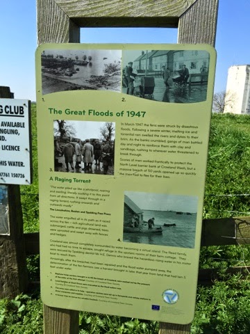
Just before we joined the path was this notice giving information about the enormous floods caused when the snow melted after the severe winter of 1947.
Walking occupied most of my attention, as the path was quite uneven underfoot, and the wind was against us. A couple of miles of this proved quite demanding, though we saw great crested grebes, mallards, swans, not to mention a couple of deer which had trapped themselves on the wrong side of the fence near the river. One leapt over, and we can only hope the other joined it.  Just as we left the river bank we saw swallows flying around a small sluice gate. We followed a path to the right, crossed a drain via a footbridge and reached a small quiet road halfway between Cloot House Farm and Brotherhouse (Toll) Bar. 
At the junction with a busier road is St Guthlac's Cross, an old boundary marker for the estate of Crowland Abbey. We couldn't decipher the inscription, but according to Wikipedia it said "Hanc Petra Guthlac" - This is Guthlac's stone.  It dates from around 1200.  the plinth is modern, as the stone has been moved from its original position.


We took the road to the right, scorning the bridleways marked on the map, thinking they could be tricky walking. The road wasn't too bad - just a tad too busy to be pleasant.
It took us to a few houses with the  unlikely name of Peak Hill, before finally reaching Cowbit  - pronounced Cubbit, according to the village website.

Unfortunately for us the village pub was demolished some time ago, so we feasted on cereal bars and our flasks of coffee. It felt like the back of beyond, but is only four miles from Spalding, and is on the bus route from Spalding to Peterborough, via Crowland. Were we tempted? Not seriously, since the weather was so fine, and now we knew we were shortening the distance left with every step.
Cowbit Church - St Mary's.
For the return leg we took the bridleway parallel to the road, over Cowbit Wash, as far as Brotherhouse Bar, then we walked along the quiet road, with a few school run cars at this time. We caught sight of a small muntjac peering out from a field of rape.  The road turned left at a right angle at Cloot House, carried on past Little Lodge Farm, twisting to the right then the left and eventually brought us into Crowland, not far from the Abbey. 

A walk which seemed longer than it was took us through the town and out along the Gravel Causeway to the car. Further than we've walked for a while - probably a whisker over ten miles.

Thursday, February 5, 2015

Crowland

We decided to spend most of today exploring the town of Crowland - a place which used to be one of the many islands in the fens. This meant that our walk was short - five miles, maybe. It was cold too.
The Welland valley covered in last night's snow

Tixover church

The approach to Crowland
Crowland is a place I am more used to seeing in hot weather, sometimes after a sweaty cycle ride through the fens, but today was very different.

Triangular Bridge
The bridge used to span the two rivers which met in the town.  Before the fens were drained the main streets of Crowland were waterways. There was originally a wooden bridge, but this structure was probably built in the fourteenth century.

Not Cromwell, may be Christ, or may be an abbot

Thatch cat


The Abbey
There are some excellent self-guide sheets available, both for the present church and the outside area, which used to be a very large abbey. It was dissolved by Henry VIII in 1539 and also suffered a siege in the Civil War, when Cromwell's forces defeated the local Royalists and the abbey was destroyed in 1643.
On the rood screen - St Guthlac arriving at Crowland in his boat
Guthlac was a Saxon noble and warrior who later became religious and a hermit, arriving at this isolated island ( with a servant or two) to spend his life in contemplation and prayer. For more details see this blog.
An unusual aggressive green man
Other curious items in the abbey include a heart casket, in which hearts of those killed in the crusades were kept and the skull of Abbot Theodore, who was slain by Viking invaders while he was praying. The skull is kept in the abbey, but locked away since it was stolen in 1982, but returned 17 years later with a note of apology. 
'As a callow youth, I stole the skull and as a responsible adult, I return it!'
The fifteenth century parish chest is a hefty affair with three locks. Three people had one key each, so that no one person could unlock it.


Halley's comet - the hairy star, apparently seen by the stonemasons.
 It was cold even inside the abbey, and it was essential to warm up before we walked anywhere, so off to the Copper Kettle tearoom we went. The warm fire and friendly company worked wonders.  
We took the track towards Peakirk, following this as far as Kennulph's stone. According to Heritage Gateway, this is the story:
After a succession of lawsuits about the possessions of Crowland Abbey in the marshes, and the appointing, in 1389, of a commission to enquire into the marking of boundaries, new stone crosses were erected at Kenulfston and elsewhere. In 1394 men of Deeping destroyed the cross and were imprisoned in Lincoln Castle, where they remained till their friends set up another cross at Kenulfston. A modern block of stone with date 1817 has been erected on the old base, which stands on the banks of the Welland. 
Kennulph was the first abbot of Crowland in 716.
Kennulph's stone
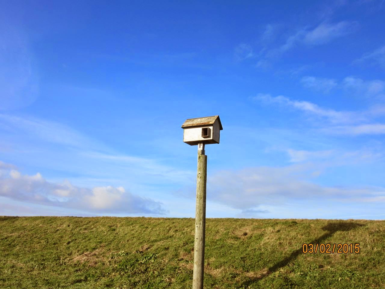
A bird box - not sure what for though
We returned via a path nearer to the river, through a field with a rather importunate pony. We were glad to shut the gate on this one, and turned right parallel to the road from Fen Bridge. Not a day for many people to be sitting on the benches, and five minutes was long enough for us!


Wednesday, January 28, 2015

Around Deeping St James

Walk done January 27 2015, starting at about 10.30am.

Marta and I continue to explore the Welland. Our initial hope was that we might reach Crowland, but we decided to take things a little easier. 
Our first problem was the route. We were not sure how far along the left bank of the Welland we could walk, and wanted to avoid any road walking, since the road concerned is a typical fenland road. It's pretty straight and tempts people to speed.  In fact it is possible to walk along the high bank, and beside it, but underfoot it was a little soft which made it harder going. On the way back the wind was in our faces too.
We parked at a space used by local dog-walkers, just after Deeping St James, where the road bends sharply to the left.  
I picked some local brains first, a couple who were looking for the seal which has been seen during the last few days in the river. They hadn't seen it, but recommended the walk anyway. 

The first half mile or so follows the Welland south east, along a tarmac private road, with Deeping Lakes Nature Reserve on the left, and the river on our right.

A glimpse of one of the lakes through the trees
The path goes under the mainline railway, and the river soon joins Maxey Cut, and becomes a more serious-looking ruler straight river, with raised banks. It flows northeast.
Where the waters join there was a little egret

Cropped.
Soon after turning the corner we found the entrance to the nature reserve - our plan at present is not miles under boots, but exploration, so in we went.
A group of children with teachers were visiting, and we stopped to chat - they'd seen herons, little egrets and also a long-eared owl, which often visits the reserve at this time of year. We hied us to the hide to try to spot the bird, but without binoculars we couldn't be sure. Our luck was in, as a group of birdwatchers with telescopes arrived.
At first we thought the white blob was the owl - no it was one of those pigeons pretending again. In fact the owl is in the photo, towards the top right.

The best I could get at the time, but we did have a peer through a telescope - a beautiful bird.
We left the reserve and continued towards Crowland.
The nature reserve

Lots of geese


Crowland Abbey in the distance


We walked a couple of miles or so along the river, then decided to turn back, and leave Crowland for a more leisurely exploration in future.  
Altogether we walked about eight miles today. In case you're wondering, we didn't see the seal either.

Map and details