and occasionally rides a bike.
A word of warning. The walk descriptions are not detailed enough to guide you - please take a map. The batteries never run out, and you always have a signal. Oh, And don't take left or right as gospel!

Thursday, November 10, 2011

Irchester-Wollaston-Doddington crossing-Irchester

9 miles approx. Barry, Gordon, Maureen. Misty, fine weather. 


We started from Irchester (Woodlands Road) and took a footpath between two houses, which led us over fields, across the B569 and to Wollaston.  We emerged into Wollaston near the Scott Bader factory, and some houses, including one with several chickens in the garden.


We walked through Wollaston, past the church which was slightly to the right of our route, and spotted an attractive walled park, once part of the manor house. The seats were tempting, but it was far too early for a break, so we carried on and crossed the A509.  We followed the road towards Great Doddington, turning right after a third of a mile or so.  Our path turned slightly to the left (north-west), and we took a path between two lakes, and along a track towards Doddington Crossing and the Mill where several narrowboats were moored.


At this point we joined the Nene Way, and followed it along the river into Wellingborough. This was part of my route on August 5th, on a fine hot day!  


Wellingborough Embankment - just right for a stop. Thank you for the scones, Maureen!

After a break we carried on along the riverside.(I did a bit of this accidentally on August 16th)  Loads of swans, ducks and gulls hang out there.  There were a lot of horses grazing.  Most of them had manes and tails covered in burrs, like this poor fellow.  
When the mainline viaduct came into view we started to make  our way towards Chester house.
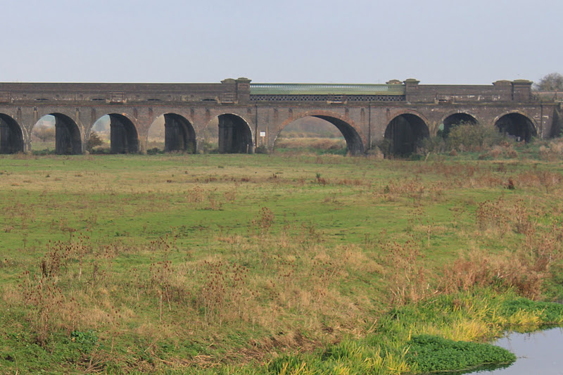
At this point we joined the Nene Way again (see my walk on Tuesday 16 August).
We walked around to the right of the house to investigate the site of a walled Roman town. We saw part of it, but there may have been more.  
Behind Chester House, which is being restored, repaired or rebuilt, is the remains of a walled kitchen garden with conservatory and fruit trees - just out of our reach!
We had to cross the A45.  It has a central reservation and path, so is possible with care. Then we took Chester Road, past Townend Farm into Irchester, passing Lower Farm, and a cottage called Cwmnene.  We made a small detour to look at the info board in St Katharine's Walk, and to seek out the (very small) Catherine Wheel which is part of the weathervane. Ha ha - wrong lens again ;-)
I like the banded stone effect.  The spire is the tallest in the county.
A short walk took us back to the start of the walk.

I was pleased to have walked along part of the Nene I hadn't covered before.


October 2012: Update about Chester Farm site - they may open a heritage centre for the Roman site.


Map and details

Monday, November 7, 2011

Fineshade-Duddington-Tixover-Wakerley

With Maureen, Barry and Gordon. Very nearly 10 miles, hence the confusing label below this post.  Weather grey, a bit of drizzle-mizzle, some mud, but we didn't get anything like wet.


We set off from Top Lodge, followed the Jurassic Way round the wood, then down to Duddington - an interesting village which I never visit unless I'm walking or cycling. It's tucked away between the A47 and the A43.
Notice on the gate of the old school. The gate was open! 


The old water mill with the mill race still there
We crossed the bridge over the Welland, into Rutland, and walked through Tixover, leaving the Jurassic Way and meeting the Rutland round. Tixover church is a little out on a limb. Maybe we'll visit some sunny day.
We followed the route I took on this walk on October 18th, when the sun shone on me.  This time we stopped for a break just before Welland Spinney, where there was a convenient set of logs and tree stumps - the perfect café.


When we reached the road between Barrowden and Wakerley we turned left and crossed the Welland, then passed the old station house. Further along at the road junction, beside what used to be the Marquis of Exeter pub we took the footpath (Jurassic Way again) which leads behind some houses and the church to the road to Wakerley Woods.
We walked along the main pathway until we met the Jurassic Way sign, pointing to the left. It can be a little tricky to spot.
Then the path turns quickly right, and can be muddy. The signs are there, but are missable.  The path continues in a more or less south-easterly direction and comes out of the woods at a gate which leads across a field and a patch of trees, eventually coming to a large metal gate where Laxton Hall is visible some way to the right, and the arch of its gatehouse to the left.
Turn left here towards the A43 - cross it and follow the Jurassic Way across a field to a bridge, then uphill past Fineshade Abbey, over a stile to a path between two fences.  This path crosses a field then goes into the woods, still climbing. Once you emerge from the woods, all that's left is a cultivated field which unobligingly goes downhill and then quite steeply up to meet the road to Top Lodge.


This last section from Wakerley is one of my favourites.


Map and details

Sunday, November 6, 2011

On the bike

With Harry.  19.4 miles.  Quite a cool wind.

No photos, though I've noted a couple of spots worth visiting at some point - the view over Kirby Hall is good between Deene and the main entrance, and Blatherwycke Lake is a good place too.   We saw a kite and possibly some black swans on the lake at Blatherwycke.

It was hard work, but enjoyable - and my muscles are more used to walking.

Plenty of short hills.

Interesting to see places I've walked recently, and noting where the paths cross the roads.

Route and details

Thursday, November 3, 2011

Harrington circular

Barry led this. With Maureen and Gordon. Grey morning, but we escaped the rain. Just over seven and a half miles.


We set off from Harrington, near the pump, just opposite the area called the Falls, as we did last time.  I had hoped for bright sun, so that I could capture the contours better, but the weather wasn't playing ball.  


Shaggy ink cap fungus and others in the Falls field, Harrington.
Some lettering on the brick built overflow bridge for Newbottle bridge.


Newbottle Bridge - there was once a village - the only evidence is some humps and bumps in a field and this bridge over the River Ise.
A rather well-hidden stile

Inquisitive cows with Desborough (?) in the background.

A slightly overgrown path leads back towards Harrington.


Wildlife spotted - one high speed fox crossing between two hedges with the white tip of its brush clearly visible.

Sunday, October 30, 2011

Kirby Hall from Gretton

About 4 miles there and back - to the road entrance on Kirby Lane

Kirby Hall in afternoon sun
Camera-shy peacock

Saturday, October 29, 2011

Eyebrook Reservoir

With Harry, late afternoon.  Some sun.  No garmin link - but I know it's just under 5 miles.


We saw lots of swans, geese, the odd grebe and heron. A little later a noisy flock of geese clattered over our heads before coming down on the water.  And a pair of bullfinches flew out of one of the hedges.

Wind-blown willows


A bullock-moot

Thursday, October 27, 2011

Short strolls

I'm posting this since we decided not to walk today - muddy fields in the rain do not appeal!

So - from a couple of wanderings yesterday -
I hope this young swan copes.  On the bridge over the Welland I met two men who had just released the bird, after finding it in a field. They'd consulted a vet, who said the best thing was for them to put it in the river.

The village of  Seaton(I think) is in the spotlight, seen from the track to the old quarry near Gretton.