and occasionally rides a bike.
A word of warning. The walk descriptions are not detailed enough to guide you - please take a map. The batteries never run out, and you always have a signal. Oh, And don't take left or right as gospel!

Wednesday, April 5, 2017

Illston, Burton Overy, Little Stretton, Kings Norton


Monday 03 April, 9.50 am. With Norma. Fine sunny weather, and very little mud underfoot.
8.3 miles in all.

This is the same route as this walk  and this one, but it's spring now, and feels different. 

Leave Illston by the gate at the end the no through road past the pub, and go up to the next gate on the left. Turn right, and at the end of the next field take the left-hand path. If you can't see it, take the right hand one, and you can join the correct route a couple of fields down via another stile.

Keep Illston Grange on your right, and follow waymarkers to a stile leading on to the metalled section of Gartree Road. Cross the road and follow way markers (easy to see at this time of year) through a few fields, coming out near a farm on a road with a cattle grid. Cross the road and follow the path over two fields to the road leading into Burton Overy.

Houses in Burton Overy.
 Turn slightly left then right, past The Bell, and over a small bridge, near which is an oak tree planted by the local WI in 1988. Soon afterwards there is a path leading off on the right hand side into a field full of sheep and lambs.


The path goes slightly uphill to the corner of the woodland and on to meet the road between Kings Norton and Great Glen.  It becomes a bridleway, and is easy to follow, behind a couple of houses, labelled on the map as The Cottage. Some way further on, at a field boundary there is a permissive path allowing you to take a short cut towards Little Stretton. 

At the road turn left, and look for a driveway and footpath. Public Footpath for 420 yards it says, but it leads past a pond, and a large house, then into a narrow path behind some barn conversions, and into a field behind the church, and round into Little Stretton churchyard.

The church is more visible in spring, through the trees.
 A bench near the church provides a good stopping place.


Little Stretton church
Almost too pleasant to move, but needs must. We walk out to the road through the village, and just outside the footpath goes off to our right, clearly marked, and made good through the growing rape crop. It leads us to Kings Norton, coming out very close to a farmhouse, on the road above the church. We walk down, past the church, turning back to snap this most photographed of churches - by me anyway.

Kings Norton Church showing off its best side in the sun
We take the road to Illston, and when the road bends to the left we carry on ahead on a byway. Today the cows are the other side of the fence, and one or two sidle up to say hi.
GPS is the latest fashion, darlings.
 From here it's straightforward. Follow the byway to the road, turn right and at the next junction look for a footpath sign in the hedge on the left. This takes you back past Illston Grange, which is on the right. There are lots of sheep and lambs here too.
In the opposite corner, a little way past the Grange is the path, through a series of gates near the horse area. Follow the waymarkers and the path goes along field edges down into a dip and then uphill and back to Illston.

Illston on the hill, Kings Norton, Gaulby

With Maureen.  Walked on Thursday 30 March 2017.
The same route as this walk from 2013.  Just over 6 miles, with around 300 feet of climbing.

From Illston on the Hill, through the village, downhill past the Fox and Goose pub. At the bottom, go through gate, and up to second gate. Turn right. in a while the path divides. Take the right hand fork which follows the hedge downhill, through gates and over a field (or round the edge if no path visible).
Keep Illston Grange on the left, and follow path through gates by a horse training area, then bear left across the field, heading for the opposite corner. The path comes out at a junction. Just opposite take the rough track labelled Gartree Road, Gated Road.

This takes you downhill to a footbridge over a stream. Shortly afterwards take the path to the right. At this time of year the waymarkers are easily visible. Follow them to Kings Norton, where the church is very prominent from this side.

Kings Norton Church.
Turn left and go past the church, then turn immediately right along the minor road to Gaulby.  The church clock here is one of several in the area with a single hand. There are several benches - handy for a comfortable coffee and snack!


The inside is very similar in style to Kings Norton, though smaller.
Turn right after the church and walk downhill on the Illston Road, turning left to take the footpath at a right hand bend. 
The footpath hugs the field edges, then enters the edge of woodland going uphill along a path which can be muddy.  The route is then through a couple of fields and behind the splendid Ashlands, with views toward Billesdon Coplow.
Through a gate, and turn right on to the quiet road past Ashlands and farmland, into Illston.

Horse chestnuts are close to flowering.


Tuesday, April 4, 2017

Wakerley, Laxton Hall, Barrowden

Monday 27 March. led by Tommy, with Norma, Maureen, Ken and me. 
6.5 miles, in decent weather.

Unfortunately I switched the GPS on part way round!


We set off from the car park in Wakerley Woods, and walked through following the Jurassic Way signs until we reached the next barrier after the edge of the woods, when we  turned right to take the path behind Laxton Hall.


After that we followed the newly made path which replaces the right of way through the land which is being quarried, then used for landfill. The new path is clear and generally good, but I suspect the walk will be dusty and noisy once work starts in earnest.

The seagulls follow the tractor . . .


We took the road between Harringworth and Wakerley, walking for about a quarter of a mile, then turning left along the footpath, keeping to the edge of the recently ploughed field and walking alongside the dip left by old workings, with the lime kilns in the background.
We took the Jurassic Way again from Wakerley to Barrowden, crossing the Welland.


We took the footpath on the west o Barrowden which emerges near where the road crosses the Welland, a the old station building.  t the junction we picked up the Jurassic Way footpath near the house which used to be the pub. It goes behind the church and comes out on the road. At present they are building an access road to the quarry near the corner.
We followed the road and picked up the Jurassic Way footpath back to the car park.
We're almost back
 Lunch at Barrowden Community shop.

Skeffington, Rolleston, Noseley

With Maureen. Thursday 23 March, 10.20 am. 7.4 miles.  Followed the same route as we walked on March 6th with Norma.Weather good, but there's still a wind.


The horse chestnuts are about to produce leaves and flowers.

Lambs in plastic coats against the cold. 
Ready for the rest of the walk!

A thatched human on the roof

fox among the  . . .


Pitsford Water in the rain

Monday 20 March with Maureen.

Weather forecast not good, inspiration lacking, so we decided on the old faithful. The weather held out until the last mile or so, and then rain came down heavily. More fool me for leaving my big waterproof in the car and risking the lightweight-just-about-showerproof gear.  Good job the cafe was there, so that we could dry out.

No photos either. A walk for walk's sake!

Cranford and Twywell Hills and Dales.

With Maureen. Thursday 16 March . 7.8 miles. Around 200 feet of ascent. 

We set off from Top Dysons, near the Old Forge in Cranford St Andrew, and walked along St Andrew's Lane, as far as the footpath to the right, which took us through the grounds where the church and hall are situated. There were plenty of sheep and lambs.

The path heads across the parkland and emerges at The Green, which becomes Church Lane and passes St John's church.
Shortly afterwards we take the footpath which leads through a field, up to a gap in a fence, and down a dip with a footbridge.  We should have stayed further to the right, as we ended up close to the off-road tracks in the old quarry. In the end it was not a big problem and we made our way to Twywell. We walked along High Street, the Green and Lower Street before following the footpath sign to Twywell Hills and Dales, on the site of old ironstone workings. 
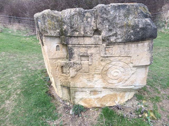
The first part of the path is through pleasant woodland, then there is a section where the noise of the A14 is intrusive. We followed a path between fences which brought us to this carved stone.
Notice the Dartmoor ponies which are there to graze and protect the habitat.

By following the map and path signs we made our way back to Cranford - almost seven miles in all, but I need to walk it again to get the route clear.

Monday, March 27, 2017

Great Easton, Neville Holt, Drayton, Bringhurst.

Monday 13 March 2017. With Norma, Maureen, Tommy and Ken.  Just under six miles. Great sunny weather, with a little mud underfoot on occasions.
Nevill Holt from the path
Similar route to last Saturday, and also this walk from March 2014.  we began from the green, near the pub, and walked along Brook Street and Deepdale to pick up the footpath towards Nevill Holt.
 We took the path which  leads very close to the buildings of Nevill Holt, with the statue of the opera singer, Bryn Terfel . . .
 and this horse's head.
 The path takes us out on to the road to Drayton, and we walk downhill for some distance, watching a few cyclists making their way upwards.
 Break time at the bench with a view.

 Down into Drayton, past a garden gate decorated with a metalwork spider - there are smaller versions near the wall behind it.
 Then straight through the village and the tiny church building on the green. We take the path towards Bringhurst, and turn to climb the hill to the village.

At the road junction we turn right, and soon take the footpath on our left, labelled "Great Easton".

Lunch at Cottingham community cafe.