and occasionally rides a bike.
A word of warning. The walk descriptions are not detailed enough to guide you - please take a map. The batteries never run out, and you always have a signal. Oh, And don't take left or right as gospel!

Saturday, May 9, 2015

Through the woods at Buckland Abbey

Sunday 3 May

A day of showers and brighter spells saw us driving out for a coffee and some air. Yesterday we had vegetated after a couple of days driving to Devon.

First stop was the village of Buckland Monarcorum, to have a look round a local art exhibition - there were some attractive landscapes, notably by a Richard Mabey who is the author and illustrator of  a book of local walks - he is not the man who wrote Food for Free, I think.

A stroll downhill into the village with its impressive church, and quaint houses - and we still hadn't had any caffeine. Nearby was Buckland Abbey, once an abbey, then home to Sir Richard Grenville and later to Sir Francis Drake, now a National Trust property.


It was certain to have a cafe, and a fine situation. 

We paid the dues to go into the garden and grounds and enjoyed a coffee and scone. The staff on reception  recommended a three mile long estate walk through bluebell woods. One of the most beautiful woodland walks - especially at this time of year. Spring flowers in abundance - celandines, a few wood anemones, pink campion, yellow dead nettle, wild garlic, herb robert, and masses of bluebells - though not at their peak yet.


The woods are steep and full of mosses of all kinds, ferns and trees showing new leaves. At the bottom of the slopes flows the Tavy, and we joines a riverside path for a short distance, and saw a family of ducklings with their mother.

We met no one on the woodland part of the walk, and there were no more than a few drops of rain.
My phone app tells me we climbed the equivalent of 27 flights of stairs!


Wednesday, May 6, 2015

Burrator Reservoir

We ended up here for an afternoon stroll, after a morning waiting in for the Autoglass man, who turned up with the wrong windscreen! Still and all, we took the opportunity to get some laundry done, andthe weather was on the poor side of acceptable.

Burrator reservoir is not far from Yelverton. We called in at the Discovery Centre, which was opened last year. Lots of information about the building of the reservoir in the nineteenth century, and what the area was like previously.  


We started our walk round the reservoir from   Norsworthy   Bridge and walked clockwise past the arboretum, then along some muddy paths as far as  the ruins of Longstone Manor, where there are an old stone cider press and some stone water tubs as well as part of the house.

Further round we came to the two dams, Sheepstor Dam and Burrator Dam, before following the path past a waterfall emerging from a pipe, past the Discovery Centre and eventually back to the bridge.

Lush, green, mossy trees, primroses and bluebells, and the wind-ruffled water all added to the attractions of this three and a half mile walk.  All that was missing was an ice-cream van or a café. 


Castle Drogo in the wind


http://www.nationaltrust.org.uk/castle-drogo/

We had a short stroll through the grounds after visiting "the last castle ever built in England". Itwas built by Julius Drewe, founder of the Home and Colonial Stores, between 1911 and 1930, and designed by Lutyens.  At the moment there's a huge restoration and repair programme inder way, and most of the castle is wrapped in plastic sheeting and scaffolding, though the interior can be visited, and on normal days the works can be seen from a viewing tower.  When we were there the winds were so high that the viewing tower was closed, and the gardens too. We were happy enough to shelter from the rain and winds for a while inside.

The situation is magnificent, with wide views towards the moor, and the walks down to Fingle Bridge and Drewsteignton look well worth considering in future.

Monday, April 27, 2015

Lyddington Uppingham and back via Stoke Dry hill

Monday 27 April, 9.30 am. With Mel, Norma, Chris and Marion,  Chris, Sue, Jill, Tommy, Maureen, Steph, Terry, Liz, Phil and me. Dry, sunny, no real wind. Conditions underfoot very dry!  About 7 miles.

A sunny morning saw fourteen of us meet in Lyddington for this walk. We walked along the road to the footpath leading uphill via stiles and fields of sheep and lambs towards Uppingham Community college. 

The path goes across the playing field and downhill and up on a wooded path which emerges eventually at Uppingham market place - either via a back alley, or through the churchyard.
We stopped for coffee at the benches opposite the market place - there are a couple of cafes nearby which sell decent takeaway coffee.
We turned along High Street West,  past the school and Uppingham Theatre and some splendid floral displays, before joining Stockerston Road where a public footpath took us off to the right.  From this high viewpoint we had some wide views of rural Rutland.
A left turn with the hedge on our right took us past King's hill Lodge, and back on to the Stockerston Road. We turned left and walked for a hundred yards or so. Our footpath was on the right, and took us along the Rutland Round past Stoke Dry Wood emerging above the village of Stoke Dry at Manor Farm. The views over Eyebrow (! autocorrect?)  Eyebrook are excellent.

We turned left and walked to the A6003. We crossed this and took the footpath to the left, rather than the road down to Lyddington. The way was very straightforward, and soon the village was in sight.
Not long before we arrived back at the cars.


Friday, April 24, 2015

Great Oakley, Newton, Little Oakley


Thursday 23 April

With Maureen. A fine sunny day after early cloud. In all about 8 miles.

We walked down to the Spread Eagle - around a mile before starting the walk proper as described in Mel Jarvis's "Around Corby" book. 

From the pub you walk through the tunnel under the road. When this reaches another road, turn right over Harper's Brook, and then left on the other side of the road. The path goes behind some houses and emerges onto a small road. Today the flowers were lovely in the first garden. We turned right along this lane and right at the end, taking a small path on the opposite side of the road we reached.  After around 100 yards we reached Woodlands Lane, and turned  left. We walked to the end of this, ignoring two footpath signs on the way.
After a turn to the right, there is a path through a metal gate, and over a bridge. There is a paved path going up to the top left corner of the field, leading to the road with the old station building, slightly to the left.

Old station building and the footpath we didn't take
At this point we walked along the road, turning left at the first road, then under the railway bridge and onto the bridge over the new Geddington bypass. After the road bridge we turned left and followed the footpath parallel to the new road until it turned right, along the old route. It crossed a stream and then went uphill with the hedge on our right. After the first field, the path headed diagonally to the left. At the highest point near an electricity pylon it crossed another path. We paused for a snack before taking the path continuing our line of travel. This was clear on the ground.  The path led us to the road between Newton and Geddington. Today we chose neither, but turned very sharply left along the nearby footpath leading back towards Little Oakley. The two paths form a V shape in the field.

We followed the instructions in Mel's book, across the first field, through the hedge, across the second field and through another hedge.  There is a hedge on the right. We walked alongside this through a short section of a field, then through another hedge. 
Up here we here the whistling call of the peewit (lapwing), and see a few flying around. We misread the instructions at this point and ended up in a corner near a pylon, with no way through. A short retracing of our steps to a track we should have taken to the left, slightly uphill brought us back to where we should be. We followed this until we could see Little Oakley ahead of us - see picture below.

The track joins a road into Little Oakley just before the stream. Just afterwards the path turns left into a field. Slightly awkward gate. Then it follows the stream before heading towards the new bypass once more. There's a slightly dodgy very small stream crossing.  This time we see the viaduct on the other side, and cross over using the underpass.


Looking back
We go under the viaduct and follow the path past a private road to Oakley Hall and into the parkland near the church area. We walk through and back out into Great Oakley, turning right and taking Levin Road back up to the  mini roundabout, and then left to the main Corby to Kettering road at the big roundabout.


Map and details

Wildlife noted - lapwings, and the first male orange tip butterflies I've noticed this year.

Wednesday, April 22, 2015

Welland - Crowland to Cowbit


Tuesday 21 April 2015

With Marta. Along Welland then road, return via bridleway and minor roads. Sunny and quite warm! Alas, no pub in Cowbit. More like 10.5 miles, I think, according to the map and my internal mile counter.

Crowland greeted us with thatched animals - a(nother) cat . . .


a large bird - possibly a cormorant

and then not quite an animal but a cup and saucer on the roof of the Old Copper Kettle tea shop.  This tempted us to start the day with a coffee and toasted teacake in comfort. 

We took the car just out of the town so that we could start our walk along the Brown Fen Waterway trail along the right bank of the Welland.
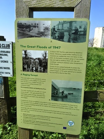
Just before we joined the path was this notice giving information about the enormous floods caused when the snow melted after the severe winter of 1947.
Walking occupied most of my attention, as the path was quite uneven underfoot, and the wind was against us. A couple of miles of this proved quite demanding, though we saw great crested grebes, mallards, swans, not to mention a couple of deer which had trapped themselves on the wrong side of the fence near the river. One leapt over, and we can only hope the other joined it.  Just as we left the river bank we saw swallows flying around a small sluice gate. We followed a path to the right, crossed a drain via a footbridge and reached a small quiet road halfway between Cloot House Farm and Brotherhouse (Toll) Bar. 
At the junction with a busier road is St Guthlac's Cross, an old boundary marker for the estate of Crowland Abbey. We couldn't decipher the inscription, but according to Wikipedia it said "Hanc Petra Guthlac" - This is Guthlac's stone.  It dates from around 1200.  the plinth is modern, as the stone has been moved from its original position.


We took the road to the right, scorning the bridleways marked on the map, thinking they could be tricky walking. The road wasn't too bad - just a tad too busy to be pleasant.
It took us to a few houses with the  unlikely name of Peak Hill, before finally reaching Cowbit  - pronounced Cubbit, according to the village website.

Unfortunately for us the village pub was demolished some time ago, so we feasted on cereal bars and our flasks of coffee. It felt like the back of beyond, but is only four miles from Spalding, and is on the bus route from Spalding to Peterborough, via Crowland. Were we tempted? Not seriously, since the weather was so fine, and now we knew we were shortening the distance left with every step.
Cowbit Church - St Mary's.
For the return leg we took the bridleway parallel to the road, over Cowbit Wash, as far as Brotherhouse Bar, then we walked along the quiet road, with a few school run cars at this time. We caught sight of a small muntjac peering out from a field of rape.  The road turned left at a right angle at Cloot House, carried on past Little Lodge Farm, twisting to the right then the left and eventually brought us into Crowland, not far from the Abbey. 

A walk which seemed longer than it was took us through the town and out along the Gravel Causeway to the car. Further than we've walked for a while - probably a whisker over ten miles.

Corby Woods

On Monday 20 April

With Maureen - and exploring the bus services!

  My camera hand was still shaky  but we managed a four mile walk in good weather. Then coffee and teacakes at the boating lake.