and occasionally rides a bike.
A word of warning. The walk descriptions are not detailed enough to guide you - please take a map. The batteries never run out, and you always have a signal. Oh, And don't take left or right as gospel!

Monday, July 15, 2013

Aldwincle circular via Titchmarsh and Islip


Mon, 2013 Jul 15 9:49 AM British Summer Time
Led by Mel, with me, Norma, Brenda, Gordon and Maureen. Very warm, pretty flat, two breaks. Just over 8 miles in all.

We set off from Aldwincle tea-room,  turn left from the car park, then cross Main Street and turn right down Baulks Lane, which takes us down to Lowick Lane, where we turn right. Soon we go through the car park on our left for the Nature Reserve,  and then along the track.  Once through the gate into the reserve we turn left through the trees, and follow the main track - we have a quick look in the hide, but can see little but distant ducks and swans, so continue. Before long we turn left and cross the river.  It looks clear and deep, with fish swimming in and out of the water weed. Almost tempting.

Weed and reflections in the river
We walk southeast towards the A605 - a busy road to cross before we take the road into Titchmarsh village.

Church of St Mary the Virgin, peeping modestly from a veil of trees
We haven't walked far yet, but it's hot, people would like more water, and there's a community shop.

The helpful woman behind the counter suggests we can sit outside, and then I spot that the shop sells coffee. This temptation is not to be resisted.  Unfortunately we can't agree on biscuits, so we make do with the drinks.


Definitely not resisted.  A great place to stop on a hot day.  But we can't hang about all day - there's walking to be done.  Onward. 
A couple of hundred yards along the High Street, and there's the footpath, going off to our right, through a stile/gate,  past a small allotment, and a few sheep, then over another stile. We follow the edges of a field, and the path soon takes us over a minor road, then further down to another crossing of the A605.  When we arrive at a lake we turn left - walking south west, just north of Thrapston.

We have another break by the skateboard park, sitting on a shady stone.  I could get used to these two-break walks in the sun.  


It's a duck's life!

Over the bridge by the mill, and up Mill Lane on the edge of Islip.  
View from the bridge

Very pretty alien invader - Himalayan Balsam.
We turn right along Ridge Road towards Aldwincle.  At the start of the woods we take the path to the right, and walk as far as the river. We keep this on our right and go past Aldwincle Lake and Heronry Lake on our left.  We rejoin our route from this morning just before the bird hide, and retrace our steps back to the cars.


Map and details

Thursday, July 11, 2013

Illston circular via Burton Overy, Little Stretton, Kings Norton.


Thu, 2013 Jul 11 9:32 AM British Summer Time - finished at about 1pm. 
Just over 8 miles. With Gordon. Fine sunny day, rollingly hilly. Good underfoot, some paths not clear on the ground.

Exploring more of the many paths around Illston.  This time we take the left hand path after the small rough field at the southern end of Illston. This goes through the middle of the field, and is fine and wide through the growing wheat.
We follow it downhill and up in front of Illston Grange, which lies on our right as we walk.

The path leads to the road - a metalled section of the Gartree Roman Road - and crosses it. We carry on in a southwesterly direction until we reach another minor road. We stray slightly from the route, then find the cattle grid and the path signs. Over more fields to the road down into Burton Overy.
I like these brickwork patterns
We walk straight on past the Bell - too early anyway. After a couple of hundred yards we find the footpath sign on our right. We pause to say hello to a solitary walker indulging in a peaceful coffee - he tells us he's on his way back home.
The black sheep family
We head north west to the opposite corner of the field and carry on in this direction until we meet the road between Kings Norton and Great Glen. The path becomes bridle way, and continues along the field edge past a couple of houses marked on the map as The Cottage. We go pretty well straight and up hill, then have a break before making our way by an unintentionally devious route to the road junction. I blame paths not made good and clear for our straying.
At the junction we take the road towards Little Stretton - this is the busiest stretch of the route, but it's not long.
Our next footpath sign is at the end of a drive on our left. Public Footpath for 420 yards it says.  It goes right into Little Stretton past a pond on our left and a big house and some smart barn conversions on the right.
In reflective mood
We cross a small field of shade-seeking cows. From the path we can nearly see the church.
The cows move considerately out of our way, and we take the path behind the church and into the small village.
Little Stretton Church -with sunny bench
We turn left along the road and follow the footpath through the hedge on our right.  At first the path follows the hedge, and the grass is quite long. We concentrate on finding our way through, and don't see the path which has been made good.  We discover it when we get to the other end of it!
For the rest of the way into Kings Norton the way is clear, though there is another short section of road.  It's warm and sunny - we have another break outside the church. 
Kings Norton church shows its less imposing non sunlit side
We walk down the road from the church, and at a left hand bend take the public byway, which runs in a straight line through fields and a couple of gates to Burton Overy Lane.
I stop to take this pic once I'm through the gate. Now all I can see is the anatomical detail of the calf's rear end.
There are more fields with cows, most of whom are wearing collars - at first I thought "Cowbells - how odd?" but they were not bells.  Could this be the explanation? Their own GPS tracker.
At Burton Overy Lane, we look back at the churches of Kings Norton and Gaulby, which dominate this area.


A short walk along Burton Overy Lane brings us to the crossroads with Gartree Road. The footpath through the hedge on our left takes us behind Illston Grange, then down hill and up along by the hedge and back to Illston.
One of the horses at Illston Grange.
Map and details - ignore anything after the 8 miles- return to start.


Wednesday, July 10, 2013

Leics Round 11 - Launde to Hallaton via Belton in Rutland and Allexton


Wed, 2013 Jul 10 9:36 AM  British Summer Time
With Marta. Fine, cloudy, pleasant. Dry underfoot. A couple of dry ploughed fields - hard work. Rolling. 663 ft of climbing. just over 8 miles.


We walk briefly along the Withcote Road from Launde Abbey, before taking the signposted footpath off to the right, behind the chapel and the gardens.  It leads uphill, through fields with sheep, to the corner of Launde Park Wood.  Here the path should cut downhill diagonally across a field, but the way is impassable, so we stick to the field edges.
Some rapeseed or similar is still blooming here - at least it brightens the grey day

 When we reach the far corner we find a gate whose fastening is impossible to open, and have to climb over it. Grid ref - SK 809045 (I think).
The path continues east,  crossing the river Chater, and turning into a wider track, and heads south to a ridge with a fine view.
 We are overtaken by a horse-rider up here. The map shows a trig point just off to our right (west), but we can't find it. Instead we take an early break and admire the view over to Eyebrook reservoir in the distance.
We follow the hedge for a while then the path goes towards the bottom left corner of the field. We keep the hedge on our left until we reach the road near Brickle Farm.  A lot of free range hens are in a field nearby.  The road takes us into Belton.

We walk through the village and down to the A47, which we cross to reach the Allexton Road.  We cross the bridge over the Eye Brook, and follow the Main Street, past the church, which is now redundant and looked after by the Churches Conservation Trust.  


It's open and worth looking inside.

We carry on along the No Through Road, to the footpath past Manor Farm. This leads behind Allexton Hall, which lies to our right.  we can't easily follow the line of the path here, and again walk up beside a hedge until we meet the waymarker. The fields here have been ploughed, and are very dry. It's almost like walking on concrete chunks. 
Not my favourite walking surface.
Then it's alongside a small wood, and turn left to go past Alexton Lodge.  Here we turn right once more and along a field edge.  We're at the edge of the ridge here, and there's a memorial seat looking southwest towards Fearn Farm.  Beautifully placed.
We walk down then up to Fearn Farm with its Zollgrenze sign - Leics-Rutland border??
We turn left to pass the farm, and then right on to the footpath
 - it's marked clearly from here to the dismantled railway - we cross by the overgown bridge and then follow the good clear path through the fields. We come out at the junction of Allexton Road and East Norton Road and walk into Hallaton past the Fox pub and duck pond.


Map and details

Tuesday, July 9, 2013

Illston circular via Kings Norton and Gaulby


Tue, 2013 Jul 9 1:04 PM British Summer Time
Led by me, with Harry. Very hot and sunny. Mostly v dry underfoot apart from short woodland section near Ashlands. Over 6 miles in fact - 403 ft of climbing.
Illston church

From the southern end of Illston village, we take the footpath (not the bridleway through the gate).  We walk over a rough enclosure with a few sheep, and in the first field make sure we keep to the right hand path.
This goes downhill by the hedge, through a gate, andover a stream before climbing through a cultivated field towards Illston Grange.  We keep the buildings on our left, and cross a couple of fields - more sheep and the odd horse. After the building we cross a large field, to the left of a large clump of trees. The footpath goes to the opposite corner and reaches a crossroads.
We take the Gartree Road,  a Roman Road, no longer used by traffic, though we did see one four by four.

We follow this rough road down as far as the ford, and shortly afterwards we take the footpath as it goes through a narrow pasture, then strikes uphill - through ripening rapeseed. Though the path is clear to see it's not easy walking with plants grabbing your ankles.
The waymarkers are easy to see, and take us directly to Kings Norton Church.  This time we meet a woman who lets us in to the building.

In 1843 and again in 1850 the spire was destroyed by lightning.  The church with its tower still dominates the landscape.

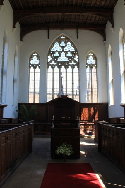
There is no stained glass, and the inside has a wonderful airiness - especially on a sunny day.

Lunch under the chestnut tree on a small green outside the church, then on towards Gaulby - the church is closed, but once again there is little stained glass.


We notice the grave of a 13 year old John Cecil, son of the vicar, who "died at Oakham School" in 1899.

We walk through the village and downhill on the Illston Road, turning to the left to take the footpath at a right hand bend. The footpath hugs the field edges, then enters the edge of woodland before passing behind the splendid Ashlands.
We come out on to Ashlands Road, and turn right. We follow this road back to Illston.