and occasionally rides a bike.
A word of warning. The walk descriptions are not detailed enough to guide you - please take a map. The batteries never run out, and you always have a signal. Oh, And don't take left or right as gospel!

Tuesday, June 4, 2013

Lyveden New Bield - the building and gardens

When I first visited Lyveden New Bield there was nothing except the house, and perhaps an info board and an honesty box. It felt bleak, unloved and hardly worth the effort.  It's all different these days, although you do have to pay an entrance fee. It's owned and looked after by the National Trust. They're doing a great job with their audio tour explanation of the building's construction, use and religious significance. Like other places in Northamptonshire there are links to the Gunpowder plot - Francis Tresham was involved, as was his cousin Robert Catesby.
Thomas Tresham, who built the house as a summer lodge was a wealthy Catholic landowner, but had to pay huge fines because he would not deny his faith.  He spent 15 years in and out of prison, but still managed to father 11 children, and find time to design and build this house and its garden, as well as the Triangular Lodge at Rushton.  

The house was designed using the numbers 3 (the Trinity) , 5 (the wounds of Christ when crucified) and 7 (significant in religion - because of the seven days to create the world, seven deadly sins and cardinal virtues, among other things).

An unfinished building, rather than a ruin
The building was left unfinished when Thomas Tresham died in 1605.  His son Francis was involved in the failed Gunpowder plot, and died later in 1605. A younger brother Lewis inherited the estate with its debt worth over £1 500 000 in today's money.   Lewis was not good with money and eventually the family estates and fortunes were lost.

looking up from the basement to the upper floors

Servants entrance into the basement where kitchens etc were - This is lower than 5'6" now

servants' entrance - hidden from the view of guests by the raised banks
The New Bield was the destination of a walk from the Old Bield, seen at the end of the orchard in the photgraph below. 
The orchard has been planted with old varieties of fruit - as described by Thomas Tresham
The walk went through the orchard, via the mounds and moated orchard, and on to the spiral mound and the New Bield itself.  The National Trust is restoring the gardens, using evidence including a wartime photo by the Luftwaffe.

A lone duckling - it later followed its mother and siblings to the other part of the moat.

The reflection would be perfect if only the wind dropped


Food for fish and ducks? Tadpoles galore!
We must have spent a good hour and a half walking around - the great weather helped of course.

Lyveden circular


Mon, 2013 Jun 3 9:32 AM Western European Time 
Led by Barry. With Norma, Maureen, Gordon, Chris and Marion, Chris and me. A few gentle slopes, good underfoot apart from some mud in the woods. Sunny warm, with a cool wind. 8. 5 miles. (or 6 for shorter route).

 We set off from the layby near Lyveden New Build on the road between the A6116 and the A427.  The path goes across the fields on the north side of the road. The oilseed rape is in full flower, but nothing like as high as usual.

We go through Banshaw Wood and arrive at the minor road in Lower Benefield. For the next three quarters of a mile the path is a tarmac strip leading all the way to Upper Benefield. A herd of young dark-coloured cows - they looked lively but took no interest in us.   In the churchyard is the  only example I have seen of a priest's gravestone facing those of his congregation. Norma pointed this out, or I wouldn't have spotted it.
Church of St Mary, Lr Benefield

 We turn left along the road for a short distance, passing a footpath which goes off to the right. Our route lies to the left, and we're walking southwest.


 A footbridge leads us over a stream and we break for a snack in warm sunshine. To be sociable we sit with our legs uphill, next time I'll turn round!  We cross the stream again - a short leap over the mud this time.  The route southwest hugs the edge of Spring Wood and Cockendale Wood.  At the end we turn to go south east towards a minor road.  Right then left takes us to the next section of path and we walk up past Lyveden Airfield, now Welland Gliding Club.
There's a memorial for a Lancaster bomber crew as we reach the next road. Here, we have a choice. Some people decide that six miles is enough, and they turn left and walk back to the cars. Five of choose to extend the walk through Fermyn Woods.


The path is a little soggy, but we follow it and emerge on the track leading to Assarts Coppice. There's a left turn where Lyveden New Bield is clearly visible.  The path leads east, with Lady Wood on our right hand side. There's a convenient set of picnic tables just inside the wood. Someone has left dry bread on one of the tables - it looks unappetising to us, and the birds don't seem interested either.

From here the path follows field edges to Lyveden New Bield car park. We walk down the long driveway back to the cars.  Four of us go back and visit the building and its Elizabethan Gardens. Audio Tour recommended.  I'll post up a few details about this later.
Looking back to the beginning of the walk.
Wildlife - No deer, though there often are in Banhams wood - kites, martins, a chaffinch or possibly bullfinch (on a phone wire, below, not very good pic), crows.


Sunday, June 2, 2013

Another Welland wander

This was between two and three miles in all - down to the bridge over the Welland, and then a bit, and a short spur along the footpath by the weir, and over a couple of fields. Glorious weather.
Oilseed rape and Harborough Hill
meadow cranesbill
cow parsley
low-flying aircraft
Buttercup field
River level is pretty low

reflections

sky

chaffinch

railway bridge

footpath up the hill

Saturday, June 1, 2013

Mini stroll at Harewood House.

This was on a dull afternoon, and probably around three miles wandering altogether.  A couple of hours on my own after looking after my grand-daughter in the morning.

Down the small hill past the big house, to the Himalayan Garden and Woodland walk, and then through the Bird Garden.
A glimpse of the Stupa, built in 2004 by monks from Bhutan
The lake was created by Lancelot 'Capability' Brown in the 1770s


Not one of the exotic birds.


More photos here.

Thursday, May 23, 2013

Offord Cluny and Godmanchester circular


Thu, 2013 May 23 9:46 AM Western European Time 
Led by Barry, with me and Gordon. Track walking, then riverside. Clear paths, very flat, dry underfoot apart from a small section in Portholme Park. Just over 9 miles. Weather mostly dry, some sun, a couple of showers. Cold wind. Coffee and a toasted teacake in Godmanchester.
Photos taken with Fujifilm FinePix L55 - my very cheap point and shoot.


Offord Cluny church
We leave the church behind us and turn right past the village hall, and then left along New Road, heading east. This soon becomes  narrow, and climbs up gently to reach Waterloo Farm.  Here it becomes a bridleway, and turns slightly to the right, then due south for a hundred or so yards, before swinging left and due east once more.  Before long it joins a north-south bridleway - with signposts.

We take the route to Godmanchester - north.  It descends gently for almost 2 miles into the town. This is part of the Pathfinder Long Distance Walk
The Pathfinder Walk (46 miles) was designed by the RAF as a heritage trail in memory of the RAF Pathfinder Force and links up the 4 airfields (Wyton, Graveley, Oakington and Warboys) used by the Pathfinders when they were set up in 1942. The route runs through farmland, fen and open heath but also has some road walking.

Godmanchester
There is a friendly café, so we stop for a break and elevenses.
The Queen Elizabeth Grammar School
In May 1561, at the request of the townspeople, Queen Elizabeth I issued letters-patent granting her name to the school. 

The two pictures below are of a building erected in 1844 by one mayor, Edwd Martin and enlarge in 1899 by another mayor, W. Gadsby.

I like the chimneys.

messing about on the river
The view should improve when the construction work is finished

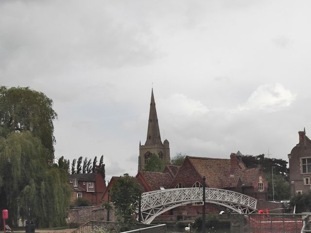
The Chinese Bridge
We cross the bridge into the lovely riverside parkland,  but have to pause to shelter from a sudden hailstorm.

We walk as far as Portholme Meadow, reputed to be the largest meadow in England. It was formed from silt when the Great Ouse flooded, and according to the info board it still floods in the winter. It's covered with buttercups and a small pink flower at present.

We're now walking along the Ouse Valley Way, and follow the path.
Comfrey flowers by the path
 We see Hinchingbrooke Castle on our right, before the path  turns south close to the river.  
Hinchingbrooke Castle has sprouted a phone mast
The trees and hedge shelter us effectively from the wind, and we're tempted by a picnic table and bananas at a Brampton pond in a conservation area.
Pond and conservation area
We make our way past Buckden Marina with its very upmarket chalets and boats, and arrive back at Offord Lock. It's a short walk to the car.

Wildlife - the usual swans, geese, ducks, a couple of terns, some swifts.
Map and details